Introduction
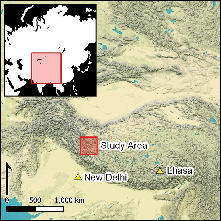
The origin and development of high-altitude agriculture on the Tibetan Plateau has attracted considerable interest during the last decade (e.g. Fu Reference Fu2001; d'Alpoim Guedes et al. Reference d'Alpoim Guedes2014; Chen et al. Reference Chen2015; Song et al. Reference Song, Lu, Zhang and Liu2017, Reference Song2021; Ren et al. Reference Ren2020a; Wang et al. Reference Wang2020; Gao et al. Reference Gao2021; Tang et al. Reference Tang2021). The Tibetan Plateau, with an average elevation of more than 4500m above sea level (asl), presents significant challenges for plant cultivation, as crops are required to tolerate hyperaridity, frost and salinity (Figure 1). Much of the previous archaeobotanical research on this region has focused primarily on the date of the introduction of different crops, including millets (Panicum miliaceum and Setaria italica), barley (Hordeum vulgare) and wheat (Triticum aestivum), in cultivatable river valleys of the eastern and central Plateau. Only a single site (Kaerdong) in western Tibet with quantified archaeobotanical data has been published to date (d'Alpoim Guedes et al. Reference d'Alpoim Guedes2014; Song et al. Reference Song, Lu, Zhang and Liu2017). Questions regarding the ecological and social variables that agropastoralists confronted when adapting their cultivation system to the particular environment of western Tibet therefore remain.
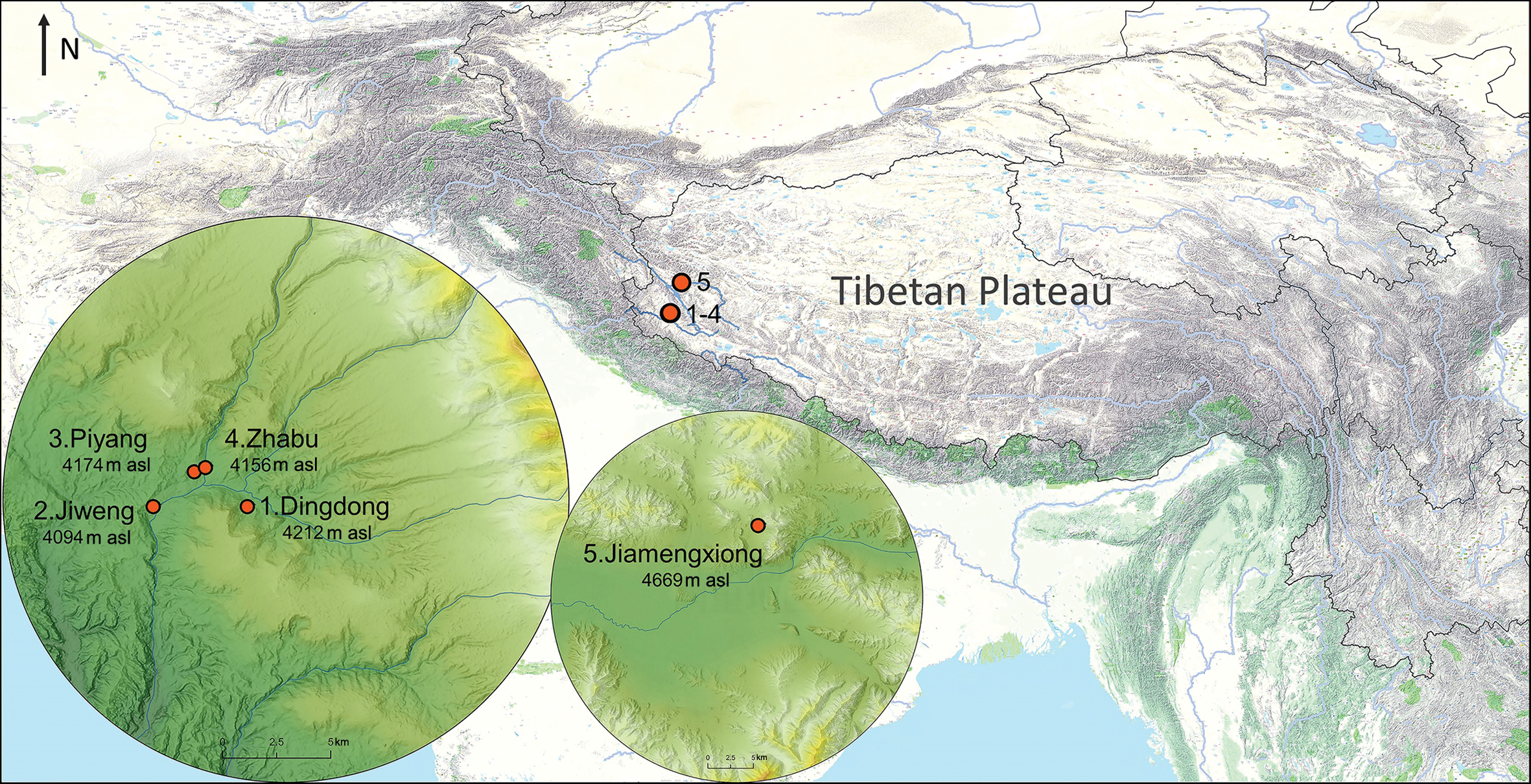
Figure 1. Location of newly studied sites (figure by Hailun Xu).
Western Tibet poses greater challenges to crop cultivation compared with the eastern and central plateau due to its much lower precipitation and annual temperatures, as well as poorer soil nutrition. Even today, this region possesses the smallest proportion of cultivatable land in Tibet, accounting for only one per cent of the country's total cropland (Du Reference Du2003). The ecology of western Tibet is highly heterogeneous (see online supplementary material (OSM)1), with relatively warm river valleys in the south and extreme permafrost steppes in the north and east. These diverse ecologies make this an ideal region in which to study early adaptations of farming to challenging environments.
In addition to ecological extremes, western Tibet also experienced a specific social, political and economic history that influenced the development of agriculture (Lu Reference Lu2015). The Zhangzhung kingdom (500 BC–AD 625) was the most powerful political entity on the Plateau before the establishment of the Tibetan Empire (AD 618–842). The large and apparently defensive site of Kaerdong is often interpreted as a military or political centre within this kingdom (Huo Reference Huo2005). The archaeobotanical evidence from Kaerdong features a diversity of crops, including naked (Hordeum vulgare var. nudum) and hulled barley (H. vulgare var. vulgare), free-threshing hexaploid wheat (Triticum aestivum), Tartary buckwheat (Fagopyrum tataricum), foxtail millet (Seteria italica, palea and lemma only) and rice (Oryza sativa) (d'Alpoim Guedes et al. Reference d'Alpoim Guedes2014; Song et al. Reference Song, Lu, Zhang and Liu2017). A similarly diverse crop assemblage has also been recovered from the nearby elite burial at Jiagazi (Ren et al. Reference Ren2020b). Given that most sites in the region are small in size, however, these large sites may not be representative of the broader regional economic system. To examine the ecological and social variables that would have shaped high-altitude agricultural decision making, we report new archaeobotanical data from five small sites in western Tibet, and compare them with published data from larger and lower-elevation sites in the western Himalayas and surrounding regions.
Excavations at high-elevation sites in western Tibet
In 2019, we recovered archaeobotanical assemblages from five small sites all located more than 4000m asl: Jiweng, Dingdong, Piyang, Zhabu and Jiamengxiong (Figures 1–3). The sites are located on a tributary of the Langqên Zangbo (Upper Sutlej River) in Zhada County, with the exception of Jiamengxiong, which is in Gar County, along the Sênggê Zangbo (Upper Indus River) (Figure 1). A preliminary study of Dingdong is the only previously published information about any of these sites (Aldenderfer & Moyes Reference Aldenderfer, Moyes, Wei and Yongxian2004; Lu Reference Lu2007, Reference Lu2008). Carbonised seeds were collected from each site for AMS radiocarbon dating (Figure 4; Table 1). The results confirm that these sites span the period from c. 400 BC–AD 550, corresponding to a period characterised by some of the earliest archaeological evidence for the emergence of social inequality in western Tibet (Lu Reference Lu2015).

Figure 2. Newly studied sites: a) Jiweng; b) Zhabu; c) Dingdong; d) Jiamengxiong; e) Piyang (scale bars: 1m) (figure by Li Tang, Shuai Li and Hongliang Lu).
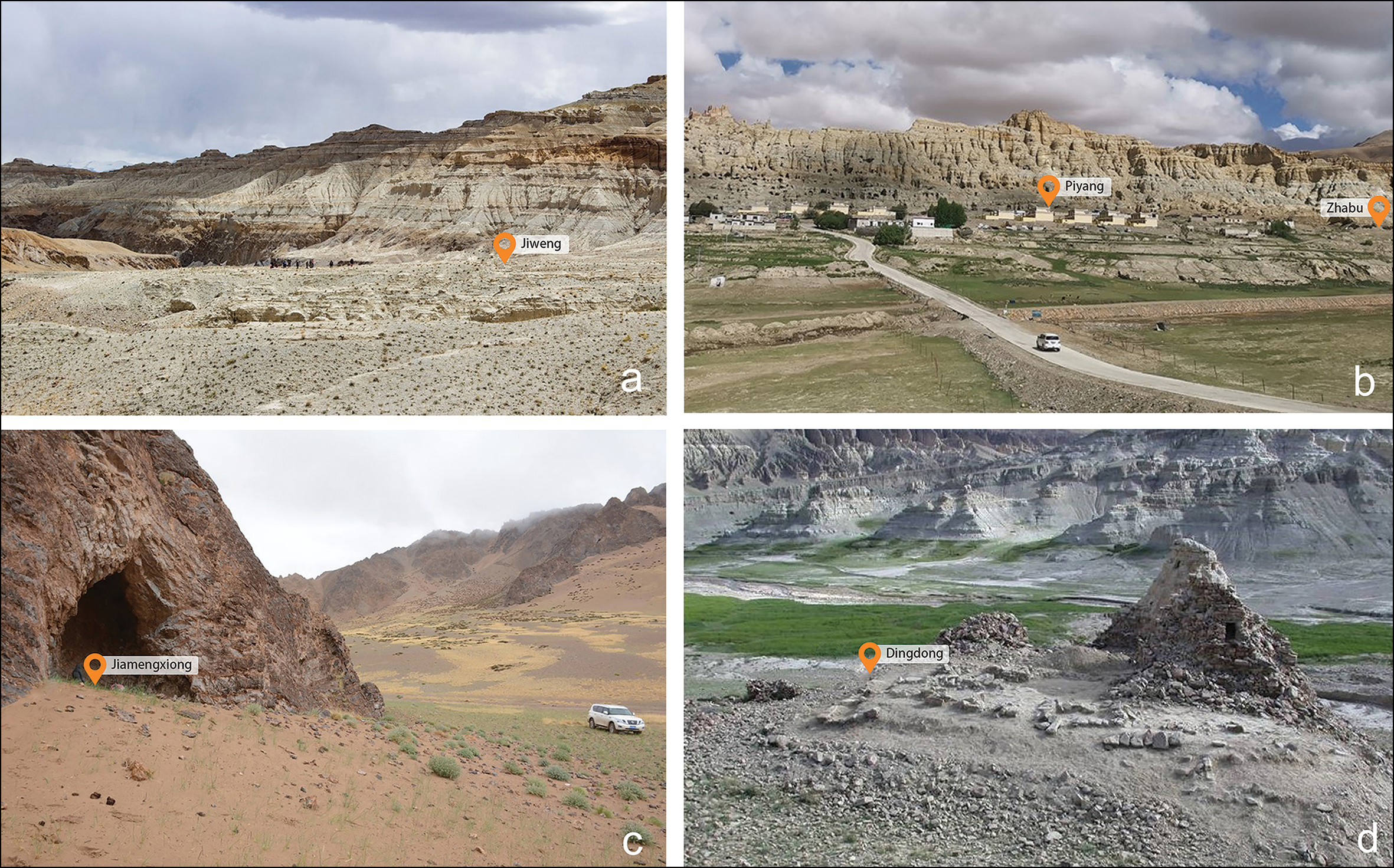
Figure 3. The landscapes surrounding: a) Jiweng; b) Piyang (centre) and Zhabu (right); c) Jiamengxiong; and d) Dingdong (figure by Li Tang).
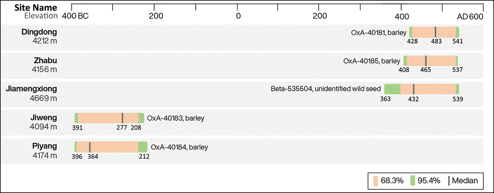
Figure 4. Calibrated AMS chronology at different sites (modelled in OxCal v4.4.2, using the IntCal20 calibration curve; Bronk Ramsey Reference Bronk Ramsey2017; Reimer et al. Reference Reimer2020) (figure by Li Tang).
Table 1. Calibrated AMS chronology at different sites (using OxCal v4.4.2 and IntCal20; Bronk Ramsey Reference Bronk Ramsey2017; Reimer et al. Reference Reimer2020).
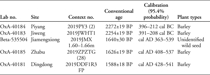
Jiweng (31°40′4.20″N, 79°46′45.34″E), a large, rectangular, stone enclosure (approximately 960m2), was in use c. 391–208 cal BC (Figures 2a & 3a). Three of five small trenches (trench nos 1, 2 & 5) were excavated within this enclosure; the only artefact recovered was a single, almost complete pottery vessel in a red, sandy fabric from trench 5. The paucity of artefacts and the simple layout of Jiweng suggest a seasonal campsite, similar to those known locally from later, historical contexts.
The settlement of Dingdong (31°39′50.89″N, 79°49′32.91″E) was occupied from c. 348 BC–AD 541. The site comprised 11 stone structures, covering an area of approximately 150m2 (Figures 2c & 3d). Three semi-subterranean domestic spaces were excavated in 2001 (Aldenderfer & Moyes Reference Aldenderfer, Moyes, Wei and Yongxian2004; Lu Reference Lu2007). Based on comparative archaeological evidence from Mustang, Nepal, and ethnographic analogies from the surrounding Himalayan region, the excavators interpret the site as a year-round agropastoral village (Lu Reference Lu2008). Although 11 flotation samples were analysed by Fu (Reference Fu2008), no quantitative analysis was conducted. To further explore plant use at Dingdong, we collected two flotation samples from fireplaces within structures F1 and F4.
Archaeological features at Piyang and Zhabu are less apparent than those at the previous two sites due to the absence of clear structural remains. Piyang (31°41′0.49″N, 79°47′51.46″E), dating to 396–212 cal BC, is located on a terrace of the Piyang River, near the modern-day village of the same name. During a recent expansion of the village, a section with abundant charcoal, ceramics and animal bones was exposed (Figures 2e & 3b). Six flotation samples were collected from three subsections containing dense deposits of artefacts and charcoal fragments. Nearby Zhabu (31°41′5.09″N, 79°48′1.16″E) lies on a second terrace of the same river (Figure 3b). Here, a 5 × 5m test trench was excavated, revealing 32 cultural layers (Figure 2b) and a stone wall constructed on top of layer 6. A barley grain from layer 28 is dated to cal AD 408–537 (Table 1). Little charcoal and sparse ceramic sherds and animal bones were recovered.
The cave site of Jiamengxiong (32°33′14.05″N, 80°7′17.36″E) is situated at the edge of an extensive area of pasture (Figure 3c). The inner portion of the cave covers a surface of approximately 20m2. We excavated a small trench (1 × 1m) at the centre of the cave (Figure 2d). Below a surface layer of loose, yellow sand, several sequences of black, white and brown activity floors were revealed. These floors appear to have been composed of burnt dung deposits, with a few complete sheep/goat pellets visible. No ceramics, lithics or other artefacts were recovered. The deep, repeatedly used activity floors indicate that the site was probably occupied and abandoned several times. Similar caves are still used today by local pastoralists as temporary shelters and animal pens. A carbonised wild seed from the deepest layer of the cave (at a depth of 1.60–1.66m) dates to cal AD 363–539 (Table 1).
Archaeobotanical analysis
We floated 27 sediment samples (approximately 118.45l), varying from 0.25–14.6l per sample (Table S1). All the samples were floated in the field using the bucket method (Pearsall Reference Pearsall2000; Zhao Reference Zhao2004); a sieve with a 0.25mm mesh was used to collect both light and heavy fractions. Systematic sample sorting was conducted down to 0.35mm, and the macrobotanical remains were identified using a comparative collection of Central Asian botanical material and several identification keys housed at the Paleoethnobotany Laboratory at the Max Planck Institute for the Science of Human History in Jena, Germany.
From the five study sites, we report a total of 3358 carbonised seeds (see Table S1 in the OSM). Of these, 30.67 per cent (n = 1030) are domesticated grains, 65.96 per cent (n = 2215) are wild herbaceous plants, and 3.37 per cent (n = 113) are unidentified seeds (we are unable to identify the latter due to the lack of identification keys). In addition, we counted 740 unidentifiable seed fragments, and 1335 Cerealia grain fragments of either wheat or barley that could not be further specified due to their fragmentary state. We also counted 187 barley rachises (Figure 5g), three Cerealia rachises and 63 culm nodes (Figure 5h). On the basis of their morphology and association with barley rachises, the culm nodes are probably from cereal straw. In order to avoid inflating the overall abundance, Cerealia fragments, identified non-seed/fruit plant parts (rachises and culms) and the unidentifiable seeds are excluded from the final totals (n = 3348).

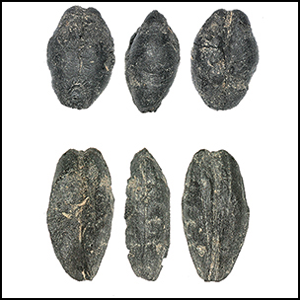
Figure 5. Examples of cereal grains from sites discussed in the text: a–b) naked barley grains in three views; c) a barley rachis; d–e) hulled barley grains in three views; f) culm node; g–h) three views of naked or hulled barley grains (figure by Li Tang).
In contrast to the situation at larger sites in western Tibet, no millet, rice, wheat or buckwheat was identified in the material from our small sites. As we report the largest sample assemblages yet from this region, we believe that the absence of a diversity of domesticated grains probably indicates that these crops were not cultivated. We nevertheless recognise that additional research is required to be more confident about this statement. Among the material we identified are ancient grains that morphologically resemble both naked and hulled types of barley (Figures 5 & S3), and there are obvious size variations among these grains between and within sites (Figure S1; Table S2). Differentiating between naked and hulled forms is not always straightforward; in many cases, hulled barley grains can lose their hulls during carbonisation and other taphonomic processes, resulting in the absence of their characteristic ridges and making them morphologically indistinguishable from naked barley (Jacomet Reference Jacomet2006). Additionally, many of the grains in our assemblages were still contained within their husks, making it challenging to differentiate the naked and hulled types. As a result, we have allocated only those grains with the clearest hulled characteristics to the hulled type (Figures 5 & S3), recognising that the actual quantity of hulled barley specimens could be higher than indicated.
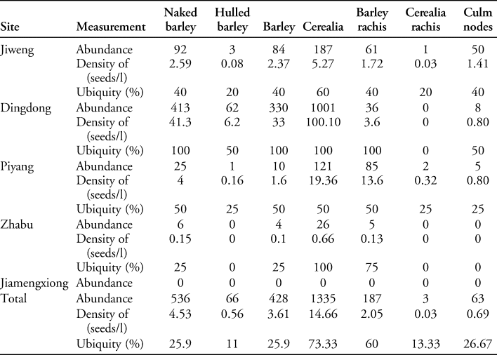
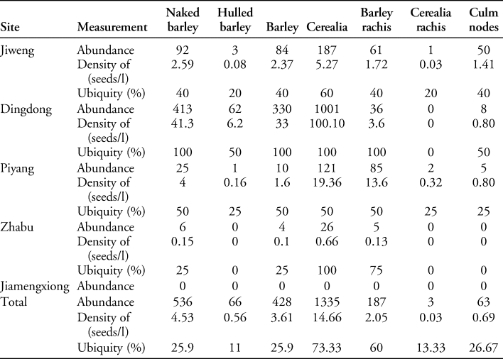
The largest number of grains was recovered from Dingdong: 413 naked (41.3 grains/l), 62 hulled barley specimens, 330 barley grains (naked/hulled) and 36 barley rachises. Naked barley grains (n = 92; 2.59 grains/l) and barley grains (n = 84) were also abundant in the Jiweng assemblage; these grains were accompanied by rachises (n = 61) and culm nodes (n = 50) (Table 2). Approximately 25 barley grains (4 grains/l), one hulled barley grain and 85 barley rachises were recovered from Piyang, while six naked barley grains (0.15 grains/l), and five barley rachises were identified from Zhabu. No crop remains were identified from the cave site of Jiamengxiong. For details about the wild plants, see OSM2.
Table 2. Total, density, ubiquity and ratios of carbonised grain remains from different sites.
Discussion
Previously published archaeobotanical data from large prehistoric sites in western Tibet (d'Alpoim Guedes et al. Reference d'Alpoim Guedes2014; Song et al. Reference Song, Lu, Zhang and Liu2017; Ren et al. Reference Ren2020a) and Nepal (Knörzer Reference Knörzer2000), as well as lowland sites in Kashmir (Spate et al. Reference Spate, Zhang, Yatoo and Betts2017; Pokharia et al. Reference Pokharia2018; Yatoo et al. Reference Yatoo2020), suggest that the inhabitants of these sites cultivated multiple types of grains. In contrast, our results indicate that agropastoralists based at small sites at high elevations in the western Himalayas are likely to have cultivated only barley. Our new archaeobotanical data from western Tibet contribute to a more comprehensive understanding of high-altitude agricultural adaptations at different elevations and give insights into selective crop choices at large and small sites.
Ecologically distinct economic systems
The variable temperatures and rainfall at differing elevations in the western Himalayas have shaped adaptive strategies (Figure 6). From the perspective of crop cultivation, we can loosely separate this region into three zones:
1) highlands, lying well above the upper limits of farming;
2) agriculturally marginal, higher altitude valleys; and
3) arable lower valleys.

Figure 6. Quantitative archaeobotanical assemblages in different ecological settings of the western Himalayas and surrounding regions; newly studied sites circled in red. Early Metal Age (c. 1000 BC–AD 700) sites are circled in black bold, sites before 1000 BC are without bold circles: 1) Barikot; 2) Harappa; 3) Kanispur; 4) Qasim Bagh; 5) Pethpuran Teng; 6) Rohira; 7) Mahorana; 8) Sanghol; 9) Hulas; 10) Jiweng; 11) Piyang; 12) Zhabu; 13) Dingdong; 14) Kaerdong; 15) Hetapatti; 16) Jhusi; 17) Sarethi; 18) Lahuradewa; 19) Rajdhani; 20) Raja-Nal-ka-Tila; 21) Mebrak and Phudzeling; 22) Qugong; 23) Changguogou; 24) Bangtangbu; 25) Bangga; 26) Karuo; 27) Jiamengxiong (figure by M. Storozum).
Highlands above the limits of farming (>4600m asl)
In the extreme highlands of western Tibet, agriculture would not have been an option, as frost and aridity present insurmountable challenges (Figure 6). One of the sites examined here, Jiamengxiong (4669m asl), is located in modern pastureland. Domesticated grains were absent from all cultural layers, throughout the deep (1.66m) stratigraphy of reused floors that probably represent many phases of occupation. Given that barley is not cultivated near the site even today, it is likely that the ancient inhabitants of Jiamengxiong more readily turned to a mobile pastoral economy than to barley cultivation, as also indicated by the deep, burned dung deposits at Jiamengxiong. While the absence of barley cultivation does not automatically mean that barley did not form part of the diet of people in this region, it is likely that either the inhabitants of the site consumed a diet more focused on animal products, or, alternatively, that the site was a temporary camp within a transhumance system, with barley possibly cultivated in permanent villages at lower elevations or acquired through exchange with low-altitude farmers. It is worth noting that, if the early occupants at Jiamengxiong only carried barley flour on herding trips, like modern pastoralists, macrobotanical remains of the crop would also be invisible.
Barley cultivation in the higher river valleys (>4000m asl)
The ancient inhabitants of the higher river valleys of western Tibet appear to have engaged in barley-based farming (Figure 6). Barley was the only type of grain identified at the small settlements at Jiweng, Dingdong, Piyang and Zhabu (Figure 6). Roughly 78 per cent of the total identified barley grains in the present study were recovered from the settlements of Jiweng and Dingdong; most were collected from hearths situated on activity floors, probably indicating daily consumption. The high quantity, density and ubiquity of barley grains (Table 2) also support the argument that barley was the staple crop consumed by local agropastoralists. The recovery of ancient barley grains, rachises and possible cereal culms from these small sites suggests that barley was cultivated locally in the Zhada Basin of western Tibet by at least c. 400 BC.
Both naked and hulled barley grains are represented in our assemblages. The hulled phenotype (expressing the Nud gene) synthesises a cementing lipid that adheres the husk to the caryopses. The naked phenotype, with a mutation of the nud gene, results in a hull-less caryopsis that easily disarticulates from the chaff; it is likely to have been selected for its obvious advantages in crop processing or culinary practices (Taketa et al. Reference Taketa2008; Lister & Jones Reference Lister and Jones2013). Compared with naked barley, the hulled type responds better to manuring and may have been more tolerant to aridity, with a lower loss of grains. Preparation for consumption, however, also requires much more time and labour, notably to remove the inedible husks (Grabowski Reference Grabowski2011; Lister & Jones Reference Lister and Jones2013). Most barley cultivated in eastern Eurasia today, especially in the Himalayas, is a naked variety, comprising about 95 per cent of all the barley produced in Tibet (Lister & Jones Reference Lister and Jones2013). Previous research has indicated that naked barley was introduced onto the high-altitude valleys of the central Tibetan Plateau and became the most popular cereal crop around 3500 years ago (Tang et al. Reference Tang2021). The role of hulled barley in the high-altitude farming system is less well understood. Some hulled grains are reported from Qugong in central Tibet as dating to c. 1500 BC (Gao et al. Reference Gao2021), from Kaerdong in western Tibet after AD 450 (d'Alpoim Guedes et al. Reference d'Alpoim Guedes2014; Song et al. Reference Song, Lu, Zhang and Liu2017), and from northern Nepal after 400 BC (Knörzer Reference Knörzer2000), as well as at Dingdong, Jiweng and Piyang in this study. While these findings suggest that hulled barley was probably cultivated by prehistoric farmers on the Tibetan Plateau, future research is needed to clarify the importance of the hulled type in the highland agricultural system. It is equally likely that the sporadic finds of hulled forms represent either an additional minor crop or contamination in naked barley fields.
Diverse agricultural systems in the lower river valleys
The warmer valleys of the eastern and central interior of the Tibetan Plateau are more suitable for farming than the highlands of western Tibet (Figure 6). Ancient farmer-hunters at Karuo in eastern Tibet were practising a millet-based farming strategy by the third millennium BC, before barley cultivation spread onto the Plateau (Song et al. Reference Song2021). Agropastoralists at the settlement sites of Qugong, Changguogou and Bangga in central Tibet practised a mixed agricultural economy, as attested by archaeobotanical assemblages containing abundant barley and/or millets, as well as some wheat and buckwheat after 1500 BC (Fu Reference Fu2001; Gao et al. Reference Gao2021; Lu et al. Reference Lu2021; Tang et al. Reference Tang2021). In northern Nepal, a barley/buckwheat-dominated farming system appears to have been practised at the sites of Mebrak (3500m asl) and Phudzeling (3000m asl) between c. 1000 BC and AD 1200 (Knörzer Reference Knörzer2000).
Evidence of a more diverse agricultural system has been identified at several sites in the lower elevation valleys of the western Himalayas (Figure 6). In the Kashmir Valley, recent data from Pethpuran Teng show that barley, wheat, broomcorn and foxtail millet, lentils (Lens culinaris) and peas (Pisum sativum) were cultivated in this region by as early as 2500 BC (Yatoo et al. Reference Yatoo2020). Later, similar multi-cropping strategies developed at the nearby sites of Kanispur, Qasim Bagh, Burzahom, Gufkral and Semthan (Lone et al. Reference Lone, Khan and Buth1993; Sharma Reference Sharma2000; Spate et al. Reference Spate, Zhang, Yatoo and Betts2017; Pokharia et al. Reference Pokharia2018). Crop diversification increased through time, with the introduction of rice, horse gram (Macrotyloma uniflorum), and multiple types of fruits and millets during the Kushan period (AD 30–375) (Pokharia et al. Reference Pokharia2018). Ancient farmers in the Swat, Ganges and northern Indus valleys, near the Himalayas, also cultivated an array of crops at least as far back as the early second millennium BC (Constantini Reference Constantini and Stacul1987; Boivin Reference Boivin, Boivin and Frachetti2017; Petrie & Bates Reference Petrie and Bates2017; Pokharia et al. Reference Pokharia2018; Spengler et al. Reference Spengler2020).
Agricultural choices among sites of different sizes
Archaeological evidence from western Tibet reveals considerable differentiation in lifeways among people based at sites of different sizes from the mid-first millennium BC to the first millennium AD. Large settlements demonstrate the differentiated use of space, including areas for larger-scale collective functions and monumental display (Huo Reference Huo2013; Lu Reference Lu2015). Elite burials contain high-status offerings of silk, golden masks and abundant metal objects (Tong et al. Reference Tong, Li and Huang2014, Reference Tong, Li, Ciren and Yao2015; Lu Reference Lu2015). By contrast, smaller settlements with limited numbers of stone structures are often accompanied by less elaborate burials, which usually contain utilitarian ceramics and, more rarely, metal objects (see OSM3). The social differences between large and small sites are also visible in their accompanying grain crops.
Barley cultivation at small sites
Our data suggest that, instead of diversifying their planting regimes, agropastoralists at small sites in western Tibet concentrated on maximising the production of stress-tolerant barley. Extensive research on modern, small-share farmers in ecologically marginal environments shows that they similarly favour risk-reduction strategies over agricultural intensification (Stone & Downum Reference Stone and Downum1999). Certain landraces of barley are better adapted than other crops to high-altitude stress, including the effects of frost, fewer growing degree-days (a measure of how temperature affects plant development) and limited rain or irrigation. Accordingly, while crop diversification was practised in many regions of the world in order to minimise risks caused by climate change (Marston Reference Marston2011), it was avoided at small sites in western Tibet. We theorise that a greater diversity of grains that are less-adapted to Tibet's extreme environments would, instead, have increased the likelihood of crop failure. In addition to barley farming, these agropastoralists also developed a productive, herd-based economy focused on sheep/goat, yak/cattle and horse (Lu Reference Lu2007, Reference Lu2008; Tong et al. Reference Tong, Li, Ciren and Yao2015; Song et al. Reference Song, Lu, Zhang and Liu2017). Monocropping may have saved time and labour to devote to these critical pastoral activities.
Crop diversity at large sites
Despite facing similar ecological challenges, larger sites in western Tibet have yielded more diverse assemblages than those recovered from the small sites analysed here, which practised single-crop farming (Figure 7). Barley was still the main crop at these larger sites, but several other grain crops were also consumed. Barley accounts for 90.57 per cent of the identified grains at the large settlement of Kaerdong; in addition, abundant barley stems and flour residues on ceramics have been recovered from the elite burials of Quta (3700m asl) and Jiagazi, respectively (Tong et al. Reference Tong, Li, Ciren and Yao2015; Ren et al. Reference Ren2020b). Wheat and millet grains have been identified at Kaerdong and Jiagazi in low quantities. A few grains of rice, which has historically been recognised as a luxury food at high elevations, have been recovered from both Kaerdong and Zeben (Fisher Reference Fisher1987; Song et al. Reference Song, Lu, Zhang and Liu2017). Additionally, two Tartary buckwheat grains are reported from Kaerdong.

Figure 7. Plant consumption at different scales: 1) Jiamengxiong; 2) Jiweng; 3) Piyang; 4) Zhabu; 5) Dingdong; 6) Quta; 7) Jiagazi; 8) Kaerdong; 9) Zeben; 10) Gurujia (figure by Li Tang and H. Sell).
Archaeologists have interpreted these larger sites as political centres, and the accompanying cemeteries contain elite burials, collectively suggesting that the larger sites may have controlled more wealth, labour and wider exchange networks, providing access to diverse food types through more flexible agricultural strategies and more extensive trade connections. Compared with barley, wheat varieties tend to be more water-demanding (Zhou et al. Reference Zhou2020), and millets are less tolerant to cold (d'Alpoim Guedes et al. Reference d'Alpoim Guedes, Lu, Hein and Schmidt2015). Growing wheat and millets successfully in the hyper cold and arid environments of western Tibet would have required more labour, given the increased risk of crop failure. Rice, tea (Camellia sinensis) and Job's tears (Coix lacryma-jobi) can only grow in warm and wet environments; they were therefore probably imported from the lowlands of the southern Himalayas, Xinjiang, or south-western and central China (Tong et al. Reference Tong, Li and Huang2014; Lu et al. Reference Lu2016; Chen et al. Reference Chen, Wang, Power and Jiang2020). The limited amount of genetic and archaeobotanical data make it difficult to construct a narrative for buckwheat in this region, but it appears to have been present in the river valleys by the late second millennium BC (Ohnishi Reference Ohnishi2000; Hunt et al. Reference Hunt, Shang and Jones2018). The diversity of plant foods provided by the local agricultural system, together with long-distance exchange networks, allowed populations at large sites to access a slightly more diverse cuisine and to engage in higher-status display.
Conclusion
Our research indicates that differing ecological and social settings across the western Himalayas shaped variable patterns of agricultural adaptation. On the north-western Tibetan Plateau, where the cave of Jiamengxiong is located, the extreme frozen-arid environment would have been too challenging to cultivate barley—or any other crops—successfully. In the high-altitude river valleys of the Zhada Basin, agropastoralists at small sites appear to have cultivated barley only, limiting the diversity of their crop repertoire. Both economic systems stand in contrast to the practices of people in the southern and eastern lowland valleys, who practised a more diversified farming system. There are also differences between sites of different sizes; the inhabitants of small sites in highland western Tibet practised monocropping, presumably to mitigate risk, whereas the inhabitants of larger sites cultivated a range of novel crops. Our findings demonstrate that the multicropping farming systems of lower altitude or large highland sites identified by previous research do not represent the entire spectrum of early farming in the western Himalayas. This article emphasises the need to study sites of all sizes and in differing ecological settings to construct a full picture of the palaeoeconomy of a given region, be it the Tibetan Plateau or elsewhere in the world.
Acknowledgements
The authors are grateful to the excavation team from Sichuan University. We especially thank Jie Li and Suwen Lu for help with sampling and flotation, and Hans Sell and Qingzhou Yang for contributing to figure design. The authors express their gratitude to Barbara Zach and Basira Mir-Makhamad for double-checking our barley identification. We also thank the anonymous reviewers for their extremely helpful advice.
Funding statement
We acknowledge funding from the Archaeological Survey and Research of the Tibetan Plateau Silk Road (grant no. 16JJD780011); the Strategic Priority Research Programme of the Chinese Academy of Sciences (grant no. XDA2004010104); and the European Research Council Fruits of Eurasia: Domestication and Dispersal (FEDD) project (grant no. 851102). Additional support was provided by the Max Planck Society.
Supplementary material
To view supplementary matrial for this article, please visit https://doi.org/10.15184/aqy.2022.80.


