


Introduction
Slushflows—flowing mixtures of water and snow—are a major natural hazard in Norway (Reference HestnesHestnes, 1998). They interfere with dwellings, structures, communication lines, power lines, etc., and are of critical concern in land-use planning (Fig. 1). They occur due to heavy rain in winter and intense thaw in spring. Whether the snowpack will reach a critical stability during rain and snowmelt depends on the relative rate of formation and discharge of free water in snowpack, which is governed by the ground conditions, the texture and structure of the snowpack, the rate and duration of water supply and the run-off conditions (Reference HestnesHestnes, 1985; Reference Hestnes and SandersenHestnes and others, 1987, Reference Hestnes and Bakkehøi1995).

Fig. 1. A huge slushflow released from a low-grade snowfield of high water content on the lower part of the mountain slope has destroyed the farm buildings at Fivelstad, Stranda, West Norway, 5 February 1990. (Photo by K. Kristensen, NGI.)
Prediction of slushflow hazard has been the objective of a joint research project between the Norwegian Geotechnical Institute (NGI) and the Norwegian Road Authorities, established in 1991 (Reference Hestnes and BakkehøiHestnes and Bakkehøi, 1995, Reference Hestnes and Bakkehøi1997). Field research and monitoring of parameters essential to slush-flow release have identified field predictors of acute hazard and critical water influxes related to different snowpack conditions. Systems for acute-hazardwarning have been developed. The critical water balance is analyzed, the main predictors summarized and an automatic system for supervising slushflow hazard is presented.
Field Programme
Two study sites in Rana, North Norway, were chosen for the project. The sites are 25 km apart, south and north of the town Mo. The site Sjånesheia is by the fjord and Illhullia 15 km inland, both approximately 225 m a.s.l. The instrumentation and field programme of the two sites was presented in Reference Hestnes and BakkehøiHestnes and Bakkehøi (1995) (Fig. 2). Temperatures, humidity, radiation, precipitation, water-level fluctuation and wind speed, direction and gust have been recorded every tenth minute for 11 years to document the intensity and variation during critical periods and slushflow occurrences. Standard snowpack observations were carried out regularly for 6 years, later primarily in connection with slushflow periods.
Fig. 2. The instrumentation at the test sites.
The Druck pressure transmitters used for measuring the fluctuation of water level in brooks and on level ground have proved to be very precise and reliable devices. Loading due to ice pressure, neither positive nor negative, has destroyed the cells. The cells are protected against snow load by a brass-needle filter and shield (Reference Hestnes and BakkehøiHestnes and Bakkehøi, 1997).
Analysis
Principal observations
Data from the 11 winters show an extreme variety in meteorological conditions. Permanent snow cover is registered from early October/January to mid-April/mid-June. The number of noticeable rises of water level in snowpack, varying between one and eight per winter, partly reflects this.
Altogether 49 such periods, of varying length and intensity, are recorded at the study sites. Thirteen events occurred during five cyclonic periods of repeated warm-front passages, another four during two periods of spring break-up. Short periods of low water were registered between the rises. The rest are classified as singular periods.
The water supply to snowpack is due to rain and snow-melt. Heavy rainfall has been registered in most periods. Snowmelt has been a significant contributor to the water budget, and the main source of water during thaw. The amount of meltwater is controlled by the temperature, wind speed and humidity at the snow surface. Net radiation has contributed to the energy budget in late spring.
Slushflow vs snowpack stability
Slushflows have been registered in Sjånesheia and Illhullia during10 and 14 of these periods, respectively. Eight current periods overlap, while 2 in Sjånesheia and 6 in Illhullia have no contemporary slushflows in the other area. Additional events are reported in the Rana district during most of these 16 periods. Slushflows have also been reported in the district during 13 periods without contemporary events in the research areas.
The registered slushflows occurred during late October to early April. All but one were small compared to some of the previous events in Rana (Reference Hestnes and SandersenHestnes and Sandersen, 1987). The stability of the snowpack during rapid water-level rise is closely related to the texture and structure (Hestnes and others, 1994). The properties of the snowpack prior to the slushflow releases and the other periods of rising water level were deduced from the meteorological data and snow profiles (Fig. 3;Table 1). The registered small-scale slushflows fit with the limited volume of new-snow conditions of early winter and fine-grained and stratified winter snowpacks. The result also confirms that coarse-grained snowpacks, which provide favourable conditions for large slushflows, were absent from the records. However, small slushflows may also be critical (Fig. 4 and 5).
Fig. 3. Snow profile. The snowpack in Illhullia after the critical slushflow period 18–20 March 2000. Top layers of new snow. The layering and weak crusts are more prominent after the period of rain and snowmelt (see Fig. 7).
Fig. 4. E6, the main road through North Norway. Six narrow slushflow paths cross the highway within a short distance. Traffic was running freely after the first closure when a flow in the nearest path hit the car, throwing it off the road. Fortunately, the driver escaped unharmed. Illhullia, 26 February 1998. (Photo by Ø. Bratt, Rana Blad.)
Fig. 5. E6 closed by slushflow. Afreight train went through the slush approximately 1 min after deposition. One week earlier the locomotive of another freight train was derailed by a smaller slushflow 15 km to the south. Sjånesheia, 26 February 1998. (Photo by Ø. Bratt, Rana Blad.)
Table 1. Incidence of snow conditions prior to water-level rise

An obvious mismatch between registered slushflow periods and water level exceeding snow height during early winter is due to open drainage channels in the research areas. The corresponding discrepancy in spring has mainly the same cause. However, stratified snow with layers of crust and ice is also observed to withstand complete saturation for more than 3 days during winter and spring (Fig. 6). Conversely, when the brooks are open in winter, intense influx of water may only cause a limited water-level rise. Running water as well as previous slushflow may keep the channels open.
Fig. 6. The study site and brook in Illhullia are surrounded by coniferous forest. The water table in this part of the channel was 1.2–1.5 m, 27 April 1994. (Photo by E. Hestnes, NGI.)
The critical water balance
The elapse of weather parameters and water fluctuation during the 49 current periods have been analyzed for a better understanding of the critical balance between slushflow and non-slushflow situations. Diagrams visualizing the actual warm-front passages and the periods of meltwater production during thaw, proved helpful in this context (Fig. 7).
Fig. 7. Elapse of weather parameters and water fluctuation during slushflow periods. (a) Sjånesheia―no slushflow released. Smooth reduction of water level. Peak water reached the top of the snowpack approximately 1 hour before release in an adjacent path (Fig. 5). (b) Illhullia―less snow in brook than on adjacent terrain. The snow height is probably around 1m. Steep rise of water level before slushflow release. A sudden drop in water table down to balance between influx and discharge after release.
Huge variations in seasonal snow cover, water fluctuation, meteorological conditions, run-off and water retention in snowpack are documented in the material. The diagrams clearly express the elapse of and the relation between the main variables. The relative importance of precipitation, wind, temperature and humidity to the formation and discharge of free water in snowpack can be roughly estimated. Estimation of meltwater according to Reference Hestnes and BakkehøiHestnes and others (1995) has been done for control. Coupled with the knowledge of snowpack properties, characteristic conditions critical to slushflow release have been documented.
Basically, there has to be snow in the potential starting zone and a pronounced rise of water level in the snowpack. The critical water-level height depends on the texture and structure of the snowpack and a corresponding rate of increase. Maximum water level in brooks is balanced by the snow conditions and the banks of the channel. Normally there is a delay in the rise of the water table compared to the timing of rainfall and snowmelt. This delay reflects the water retention due to snowpack properties as well as geomorphic and environmental conditions. However, when the principal water rise in drainage channels occurs it is surprisingly sharp and seems to be independent of the amount and intensity of the overall water supply. On the other hand, the elapse of the water table in snowpack on level ground obviously reflects these factors.
Slushflow releases normally cause a sudden water-level drop down to a balance between influx and discharge (Fig. 7b). Minor drops have also been registered when small amounts of snow are redistributed within short distances. The latter has even caused blockage and a rapid water rise to a higher level than before. After non-slushflow situations a smooth reduction in water level will take place, either rapid or slow depending on the overall snow and weather conditions (Fig. 7a).
As previously mentioned, cohesionless new snow and coarse-grained snow are most liable to start flowing. A fine-grained snowpack is stronger than coarse-grained. Snowpacks that prior to the critical weather period are compact with layers of crust and ice normally show good stability. Hard crusts and icy layers may still have a considerable capability of absorbing tensile stresses after 3 days of submersion. Once drained and refrozen, such snow structures can be very solid.
The following threshold values for acute hazard prediction are deduced from the field data (Table 2). The criteria reflect the fact that interaction between snow conditions, amount of water and intensity of water influx has been identified as critical in channels that are the prime starting zone of slushflows. Slushflows released from bogs, open fields, depressions, etc., are normally delayed.
Table 2. Critical water balance in snow-filled channels
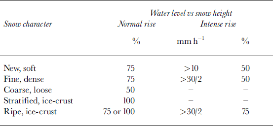
The criteria state that classification of the snowpack properties prior to critical weather periods is an essential part of acute-hazard evaluation. New snow in brooks swept away by running water without noticeable consequences is not featured in the criteria. A snowpack of fine-grained snow may have layers of varying density. A homogenous coarse grained snow cover of depth hoar is most unstable. Snowpack reinforced by frozen layers may stand days of submersion. The strength of an isothermal snowpack with layers of crust and ice are highly depending on the overall texture and structure of the snow and has to be decided on.
Fulfilled criteria vs registered slushflows
The derived criteria were checked against the water-level rise and registered slushflows in the district and at the two research fields (Table 3).
Table 3. Incidence of water-level rise vs registered slushflows
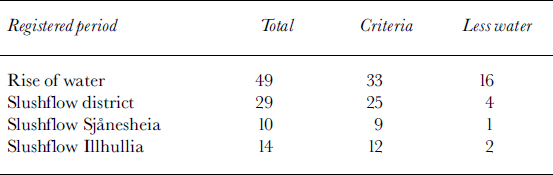
The critical combination of water level and snowpack properties was reached 33 times according to the interpretation of the recorded data.
Slushflows in the district were reported 29 times, 25 times with fulfilled criteria. This is a concurrency of 76%, although information on slushflow periods without contemporary events within the research areas comes from newspapers and random sources and not from systematic survey. The slushflows released during the four periods of minor water at the test sites occurred at low elevations along the fjord. It is likely that the criteria were fulfilled in these areas when they occurred. Therefore, with test sites located at lower elevation by the fjord, these slushflow periods might have been intercepted and the concurrency nearly 90%.
Within the test fields, slushflows were released 9 and 12 times, respectively, during periods of completed criteria, corresponding to a concurrency of approximately 25–35%. This is regarded as a high score. On the other hand, the approximately 5% releases at less water than expected are probably incorrect statements. The reason is that the elapse of the simultaneous rise of water at the observation fields where the snow height is measured normally corresponds to complete saturation of the snowpack in the channels. Conversely, the relatively low water table in the channel in these cases indicates a corresponding low snow height probably of less strength (Fig. 7b). Low snow height in drainage channels, reflecting great variation in run-off conditions during winter, is not unusual in the Rana district.
The above documentations have proved the criteria to be successful. They also emphasize the importance of finding suitable key sites when supervision of acute slushflow hazard is required. Prior research of climatic, geomorphic and drainage conditions is essential in this context. Recording snow height at the same locations where pressure transmitters are installed is highly desirable. Continuous surveillance of snow stakes and snow conditions by camera is recommended.
The attainable score in most climatic regions of Norway, when supervision of slushflow hazard is done according to the described recommendations and appropriate field checking of snowpack development during winter, should be:
District >95%
Local area >50%
Specific site >35%
Hazard Prediction and Warning
Predictors of slushflow hazard
The overall water accumulation in snowpack can be supervised by observing meteorological conditions and various signs in the field. The most prominent indicators of the stability of snowpack, i.e. the potential slushflow hazard, are listed below (Fig. 8 and 9):
Fig. 8. The water level in the central part of this snowfield is 1.3–1.5 m. Telemark, East Norway, 28 April 1984. (Photo by E. Hestnes, NGI.)
Fig. 9. Water running atop snow has deposited a small amount of slush. The running water is developing a channel in the snow. Snow height approximately 1.2–1.5 m. Illhullia, 28 April 1994. (Photo by E. Hestnes, NGI.)
Persistent or increasing rainfall on snow
Considerable snowmelt
Accumulation of water in snowpack
Standing water in snow on level ground
Abundant influx of water to drainage
Rising water table in brooks and streams
Sympathetic opening of drainage lines
Slumping snow on sloping bedrock in brooks
Saturation of snowpack in drainage channels
Running water atop snow causing minor flows of slush
Slushflows registered in neighbouring districts or paths
Normally there will be no potential slushflow hazard without any such signs unless a sudden blocking of drainage, or supply of water to snow-filled channels or genuine terrain, should occur.
Supervision of slushflow hazard
Based on the promising results from the research project, an automatic system for supervising slushflow hazard has been proposed for the Norwegian Road Authorities. However, field equipment and software may be tailored for any location and problem owner.
The main components for an operative field system are as follows: pressure transmitters (2), temperature sensors (2), snow-depth sensor or snow stake, camera, system for data recording, power supply and radio transmitter/receiver.
The second pressure transmitter is primarily for backup. The transmitters should be located as deep as possible in drainage channels to reduce potential problems with ice pressure. Both cables and transmitters have to be secured against slushflows and material transport during floods. The transmitters have to be calibrated for the expected maximum water level during winter. The temperature sensors should be located in the top soil and just above maximum snow surface. The latter is the important point in hazard supervision, indicating the type of precipitation and possibility of snowmelt at the location.
Finding a suitable and safe location for installing a snow-depth sensor in a potential slushflow path is normally a problem. Snow-stake measurements are optional. A snow stake as well as snow condition in drainage can be inspected by camera. A steel stake bolted to a footing by a solid hinge so it can easily be restored when knocked down by a slush-flow or flood is therefore recommended.
Recording and transmitting systems can be purchased. The system delivered by Aanderaa Instruments AS in Norway has proved reliable. A 12V/64A accumulator is sufficient for a whole winter’s power supply, but it ought to be charged, for example by a solar panel. The public electricity supply may also be used if accessible. Data scanning should be done at least every tenth minute to register the intensity and variation during critical weather periods.
The software for the Public Road Information Central of North Norway is planned to release an automatic warning at the central when the threshold values of water in snow are reached at locations being monitored (Table 2). During the winter the supervisor update these threshold values for every location in the system according to current information on snow character from the sites or districts.
An alert will release routines of preparedness and the necessary steps to check the conditions at the specific location and the potential hazard in general. The software will also be tailored for continuous supervision of the incoming data from the monitored locations and of course display the pictures from the cameras, and thereby render an overview of when and how conditions are changing at all sites.
Unfortunately, the funding for completion of the programme in 2003 has been postponed, so the implementation and testing of the system may not be realized the coming winter.
Public warning systems
Public warning systems activated by slushflow release or motion, and by slushflow hitting an object or communication line, are presented in Reference Hestnes and SandersenHestnes and Sandersen (2000). Briefly stated, the choice of system depends on the distance between potential starting zones and exposed locations. The systems aremainly triggered by short-circuitor disconnectionof electronic or magnetic devices. The main components used are alarms with lights and sound signals, gates for closing roads, traffic regulation by signs and informationboards.
Summary
Field predictors of potential slushflow hazard are identified. The critical height of water level is related to the texture and structure of the snowpack and a corresponding rate of water increase. Threshold values for use in acute-hazard prediction are deduced from field data and tested against registered slushflows. A promising high score was attained. Field equipment and software for an automatic system for supervising acute slushflow hazard, based on the defined criteria, are in progress. Warning systems released by slush-flows in motion are also accessible.
Acknowledgements
The authors wish to thank colleagues and other informants who have contributed to the knowledge of slushflow hazard mitigation, and the staff at the local Road Department in Rana for their encouragement and assistance during 12 years of field research. The scientific work on slushflow hazard prediction has received economic support from the former Royal Norwegian Council for Scientific and Industrial Research, the National Fund for Natural Disaster Assistance, the Norwegian Pool for Natural Perils, the Norwegian Hydrological Committee, the Nansen Foundation, the Norwegian Railroad Authorities, the Norwegian Road Authorities, the County Road Authorities of Nordland and the Norwegian Geotechnical Institute. The authors and their colleagues at the NGI gratefully acknowledge this support.


