Introduction
Archaeological research in the Western Dvina Lakeland has recorded over 60 archaeological sites, including seasonal and permanent Stone Age settlements, Early Iron Age fortified sites, and more-or-less permanent occupation dating from the Middle Ages (Figure 1). The earliest sites are Mesolithic, although stray finds from the Late Palaeolithic Sviderian Culture found in later archaeological contexts indicate that small groups penetrated into this area as early as the Younger Dryas. Hunter-fisher-gatherer strategies persisted within the surveyed territory up until c. 4000 cal BP (Kittel et al. Reference Kittel2021; Wieckowska-Lüth et al. Reference Wieckowska-Lüth2021).

Figure 1. Map of the Serteya micro-region, including archaeological site distribution (drawn by V. Filippova and A. Mazurkevich).
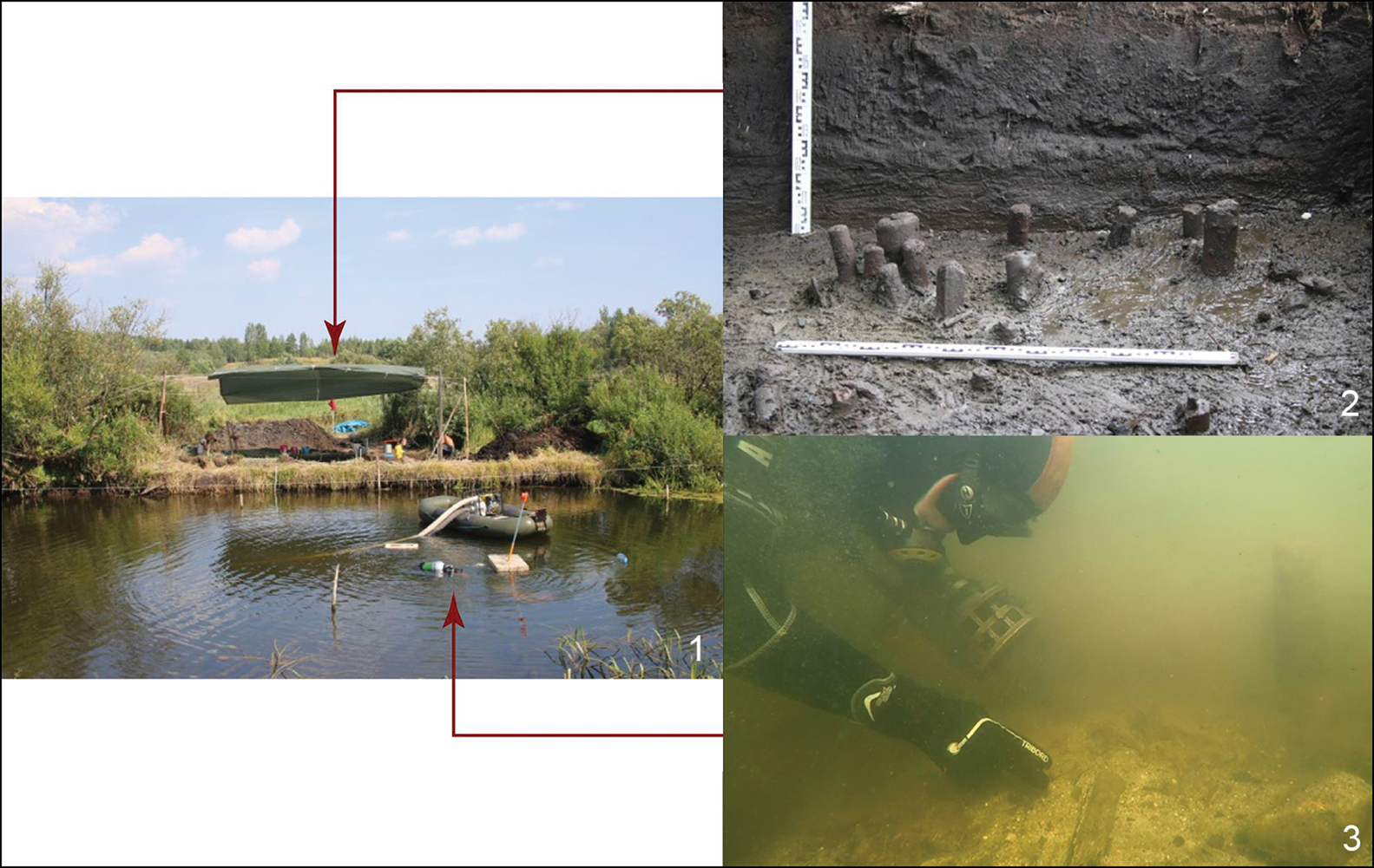
The beginning of the Neolithic in Eastern Europe corresponds with the rapid spread of a single component of the Neolithic package—pottery—during the early Atlantic period, c. 6000–5600 BC (Mazurkevich & Dolbunova Reference Mazurkevich and Dolbunova2015). This period can be referred to as the Early Neolithic, Pottery Mesolithic, Sub-Neolithic or Forest Neolithic. Different regional hunter-gatherer traditions also emerged, with pottery serving as an important adaptive mechanism and innovation in some areas, and perhaps a non-utilitarian element in others (Courel et al. Reference Courel2020). Indeed, one of the earliest ceramics in Eastern Europe, attributed to the Sub-Neolithic Serteya Culture (dated to the end of the seventh/early sixth millennia BC; Kittel et al. Reference Kittel2021), was found in the Western Dvina Lakeland. Early Neolithic immigration may relate to palaeoenvironmental changes resulting from the 8200 BP cooling event (Kul'kova et al. Reference Kul'kova, Mazurkevich, Dolbunova and Lozovsky2015), while southern Eneolithic steppe cultures are dated to the fifth to fourth millennia BC. The most prominent evidence for the Neolithic in the Serteya region, however, comes from well-preserved pile-dwelling settlements found within lacustrine deposits. These date to the third millennium BC (Mazurkevich et al. Reference Mazurkevich2009) (Figure 2) and existed during (or until) the 4200 BP cooling event (Kittel et al. Reference Kittel2021).

Figure 2. Pile-dwelling at Serteya II (photographs by A. Mazurkevich).
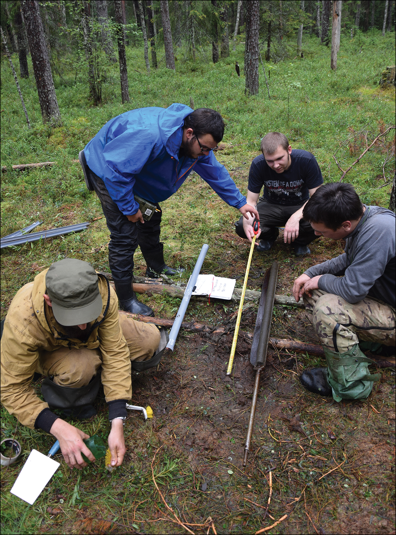
The continuation of the hunter-gatherer settlement model vs the introduction of agriculture thus appears to have been strongly dependent on climatic fluctuations (Kul'kova et al. Reference Kul'kova, Mazurkevich, Dolbunova and Lozovsky2015), as well as hydrological changes and local landscape diversity (Kittel et al. Reference Kittel2021), and remains a much-discussed phenomena (e.g. Mazurkevich et al. Reference Mazurkevich2009; Tarasov et al. Reference Tarasov, Savelieva, Long and Leipe2019; Mazurkevich et al. Reference Mazurkevich and Hafner2020; Kittel et al. Reference Kittel2021; Wieckowska-Lüth et al. Reference Wieckowska-Lüth2021). These detailed palaeo-reconstructions are primarily intended to demonstrate the ecological and economic potential of the forested areas of Eastern Europe, where immigration from the southern regions took place during the Neolithic Transition. It is important, therefore, to define local, regional and global drivers of palaeoenvironmental change, which forms the main aim of our current project, entitled A Great History in a Small Wetland: Sophisticated Human-Environment Relationships on the East European Plain in the Last 13 000 Years. To date, however, few quantitative palaeoecological reconstructions have been produced based on modern summer temperature calibration sets for the Late Weichselian and Holocene of the East European Plain (cf. Nazarova et al. Reference Nazarova2015; Nosova et al. Reference Nosova, Novenko, Severova and Volkova2019). Here, we present a detailed reconstruction of human-environment relations over the last 13 000 years, based on multi-proxy analyses of a 13.5m-deep core collected from the central part of the small (approximately 7ha) Serteya kettle hole mire (55°40´33.7″N, 31°30´32.1″E) (Figure 3).

Figure 3. Extraction of the Serteya mire core (photograph by P. Kittel).
Material
The core comprises the following organic deposits: sand and sand with organic mud (13.5–13.22m); basal peat (13.22–13.19m); clayey gyttja (13.10–11.89m); gyttja (11.89–4.20m); and Sphagnum peat (above 4.20m below ground level) (see Figure S1 in the online supplementary material (OSM)). As confirmed by the primary radiocarbon data set, these deposits present an uninterrupted record of palaeoenvironment changes and human-environment relations over the last 13 000 years, with the mean rate of accumulation being approximately 1m every 1000 years.
Methods
Detailed multi-proxy palaeoecological analyses of the organic deposits are supplemented with geochronometrical determinations, mainly comprising AMS radiocarbon dating of selected terrestrial plant macrofossils and tephrochronology. Pollen and non-pollen palynomorphs (NPP) allow for the study of regional and local plant communities, which mark climate fluctuations and anthropogenic impacts. Coprophilous fungal spores, derived from fungi that grow on animal dung, are used to identify the presence of wild and domesticated herbivores. Macro-charcoal analyses indicate local burning episodes and the use of wood as a raw material. Plant macrofossils and phytolith analyses also provide information concerning human impacts on the lake and the peat ecosystem. Palaeozoological examinations comprise an assessment of the thanatocoenoses of Chironomidae and Cladocera, which primarily contribute to a detailed understanding of palaeohydrological conditions, as well as palaeoclimate reconstructions. Water-level fluctuations during the mire phase are reconstructed based on diatom and testate amoebae assemblages. In concert with a detailed spatial analysis of archaeological and historical data within the study area (Figure 1), the development of human inhabitation of the lower Serteyka River Valley, the neighbouring Western Dvina River Valley and the surrounding area can be reconstructed.
Results and discussion
Preliminary pollen analysis indicates a clear Late Weichselian/Holocene transition in the palaeobotanical record. The surrounding tree stand during the Holocene included pine, spruce and birch, as well as other deciduous trees (see the OSM). NPPs highlight human activity and grazing pressures related to domestic or wild herbivores. Characeae oospores evidence the occurrence of algae meadows. The abundance of littoral and pelagic forms, along with the variable presence of subfossil Cladoceran (water flea) remains, suggests distinct water-level fluctuations related to palaeoclimatic shifts, which may have involved the appearance of annual wetland herb communities—similar to that seen in the present-day Rumicetum maritimi association. These changes in water level and trophy, as well as in the pH of the palaeolake, are confirmed by preliminary results from the diatom analysis, which demonstrates that periphyton and benthic diatoms are the dominant species in the basin.
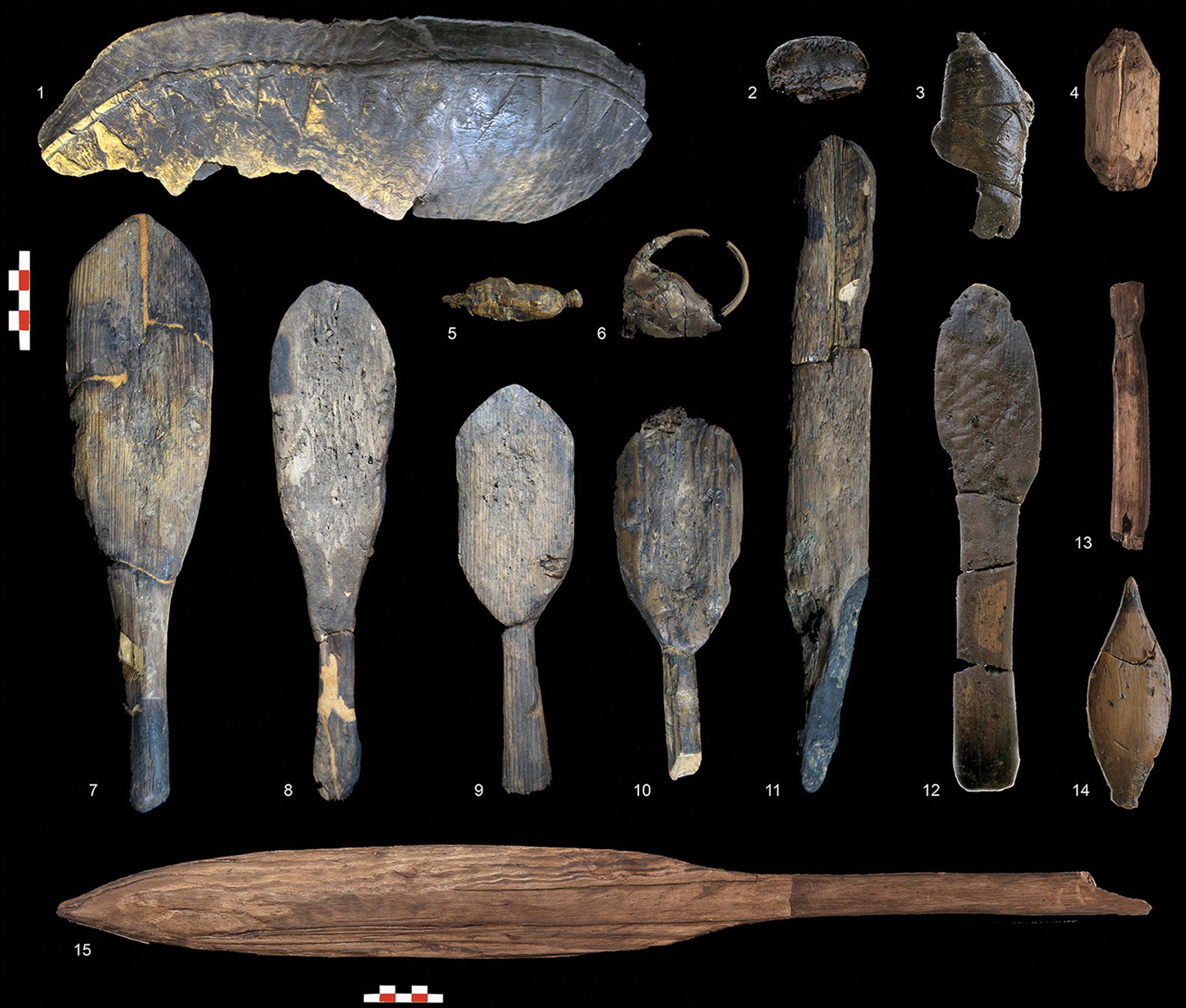
Detailed archaeological survey and excavation in the immediate vicinity of the Serteya mire has allowed various settlement types and their relative chronologies to be recognised (Figure 1). More than 20 Stone Age sites and eight from the Middle Ages have been identified within a 1km radius. These indicate occupation in the Early Neolithic (seventh to sixth millennia BC) and episodically throughout the Middle and Late Neolithic (Figures 4 & 5), as well as the Bronze Age, when a ‘ritual’ place was established nearby on a high shore of the kettle hole (Mazurkevich et al. Reference Mazurkevich2018).

Figure 4. Pottery from the Serteya II: 1, 4 & 7) Zhizhitsa Culture; 2 & 5–6) Eneolithic ‘Serteya VIII’ ceramics; 3) Usviaty Culture; scale in cm (prepared by E. Dolbunova).

Figure 5. Wooden artefacts from the Western Dvina Lakeland. Naumovo: 1) fragment of a wooden dish. Serteya II: 2) bottom of a small bast basket; 3) bast bow/float; 4) undiagnostic wooden object; 7–11) mallets; 12) spatula; 13) bow fragment; 14) float; 15) paddle. Usvyaty IV: 5–6) net sinkers; scales in cm (prepared by E. Dolbunova).
This combination of data suggests that global climatic conditions were the main factor in the development of Serteya mire over the last 13 000 years. In the Middle Holocene, the climate of the Western Dvina Lakeland appears more oceanic than in the Early and Late Holocene (see the OSM). Simultaneously, Holocene cooling events resulted in periodic increases of the water level of lakes and mires (cf. Płóciennik et al. Reference Płóciennik2022). This created successively favourable and less favourable conditions for human settlement (Kittel et al. Reference Kittel2021; Wieckowska-Lüth et al. Reference Wieckowska-Lüth2021). Palaeoecological changes may therefore have influenced the development of varied economic strategies, with both long term and transitory visits recorded in the archaeological data (Mazurkevich et al. Reference Mazurkevich and Hafner2020). On the other hand, Neolithic hunter-gatherer-fisher strategies, which followed multiple economic pathways, may have influenced the ecosystems of small water bodies during phases of more stable settlement, as confirmed by Kittel et al. (Reference Kittel2021) and Wieckowska-Lüth et al. (Reference Wieckowska-Lüth2021). At the same time, these strategies significantly limited the demographic growth of ancient populations. An increase of geo- and biodiversity of the natural landscape during the Late Holocene (Meghalayan) favoured the persistence of this subsistence economy until c. 3600 BP (Figure 3).
Conclusions
The Serteya mire core provides a reference point for both environmental history and human-environment relations over the last 13 000 years in North-east Europe. Its palaeoecological record presents a reliable, unobscured climatic and palaeohydrological reference that may be extended to the Western Dvina Lakeland. These data will provide a clearer picture of the natural mechanisms that shaped environmental changes in the Late Weichselian and Holocene, and will increase our understanding of human activity, land management conditions and anthropogenic impact on the environment within the poorly researched East European Plain.
Funding statement
This research is funded by National Science Centre, Poland (grant no. 2021/41/B/HS3/00042).
Supplementary material
To view supplementary material for this article, please visit https://doi.org/10.15184/aqy.2022.156.


