


Introduction
In the Western Desert mythological narratives link physical features, such as ranges and headlands, across the landscape and often these Dreaming nodes are also major rock art provinces. Rock art sites here frequently contain motifs that are described as representing the ancestral beings, in amongst a range of other secular and non-identified subjects (cf. Reference BerndtBerndt 1964; Reference PalmerPalmer 1975, Reference Palmer1977).
This paper describes rock art from the Australian Western Desert (Figure 1). In particular we focus on the central Canning Stock Route – the land of the Martu (Reference TonkinsonTonkinson 1974, Reference Tonkinson1978). The Western Desert is defined by its environmental commonalities and it is also a cultural bloc. Its Aboriginal inhabitants speak one language with many dialects and share a broadly similar social organisational system (Reference Peterson and PetersonPeterson 1976; Reference TindaleTindale 1974; Reference VethVeth 1993).
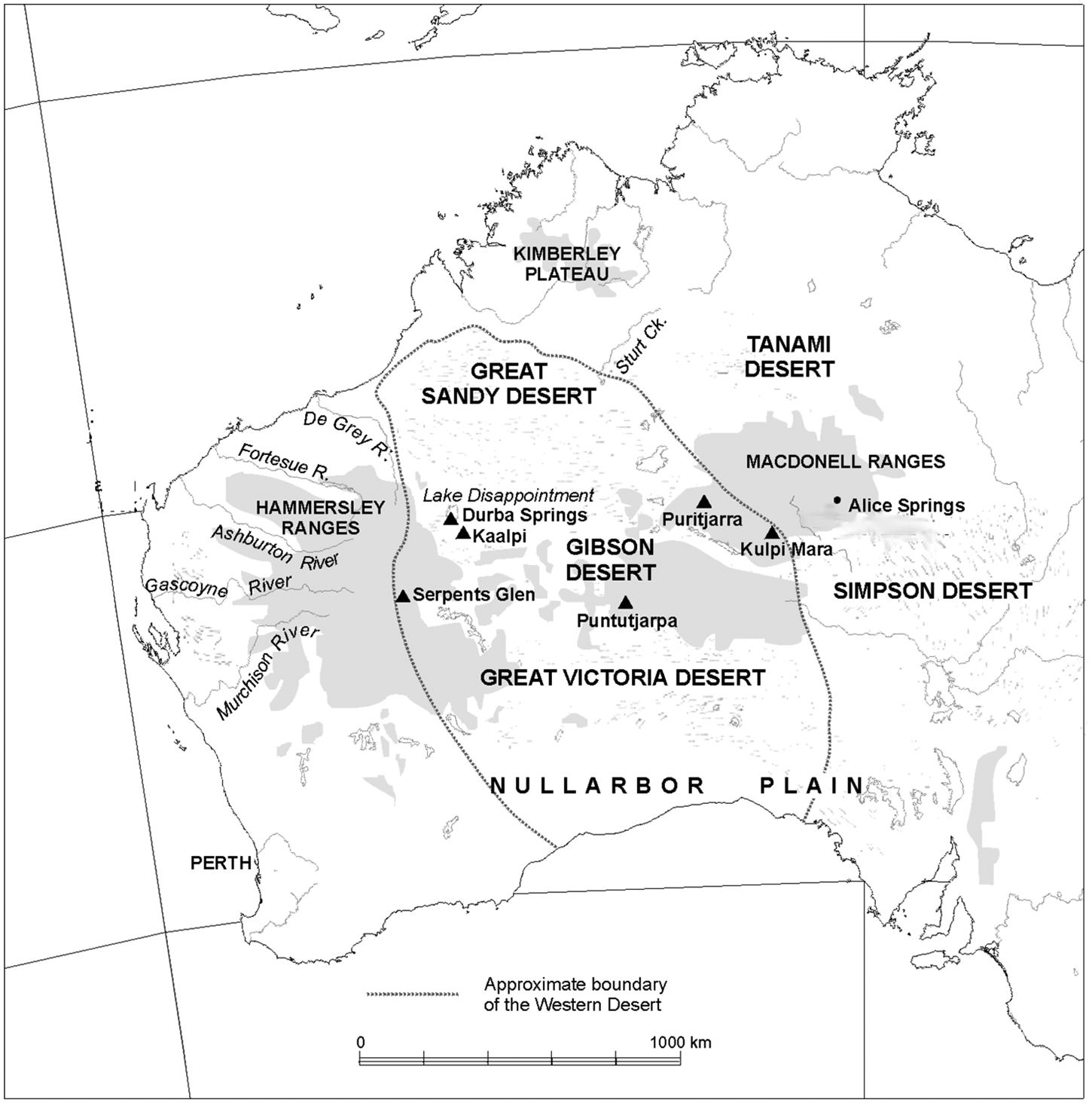
Figure 1. Map of the Western Desert showing key sites mentioned in text. The central Canning Stock Route region is located in the Durba Springs/Lake Disappointment area. The Stock Route meanders for 1,600 km through dunefields from south of Serpent's Glen north-west to the discharge of Sturt Creek at the top of the Great Sandy Desert. (Figure: Peter Veth).
Reference TonkinsonTonkinson (1974: 71–2) describes the Martu view of their mythology as follows:
The Aborigines believe that the Western Desert was criss-crossed by a tremendous amount of Dreamtime traffic … Major ancestral beings, known to Aborigines everywhere in the Western Desert include Wati Kutjarra, Two lizard men, who are believed to have laid the foundations for much of the law. Western Desert Aborigines attribute their cultural homogeneity to the fact that the ancestral beings roamed over wide areas and frequently came into contact with one another.
Western Desert pigment art is seen by Martu to have been created by humans and this depicts both everyday and secret/sacred themes. Engraved art, on the other hand, is said to have been created in the Dreamtime and is not of human origin. Engravings (or petroglyphs) represent the marks or tracks left behind by creator-beings and are places where the creator beings were literally transmogrified into stone (Reference TurnerTurner 1981; Reference McDonald and VethMcDonald and Veth 2009).
The ancestral beings are said to have had great magical power which included the ability to assume animal forms at will. They carried sacred paraphernalia and wore elaborate body decorations. They left behind objects and images of themselves in the various places that they camped so that people would ultimately discover them and draw strength and a sense of security from them (Reference McDonald, Veth and LilleyMcDonald and Veth 2006, Reference McDonald, Veth, Bloom, Giorgi and Pietroboni2007).
Mythological narratives traverse the desert and the interconnected nodes of these narratives form the basis for peoples’ totemic geographies. Ancestral beings on their ancestral journeys stopped and left evidence of their passing for people to discover and interpret. The rock art has ancient and more recent manifestations of those Dreaming beings and these are interpreted today by Martu as they undoubtedly have numerous times in the past – as mnemonic, heuristic and interpretive devices. No marking, once made, remains inert. Engravings of heavily weathered anthropomorphs, for example, are given multiple (and sometimes overlapping roles and actions) by different custodians: conversely they may have no particular currency in contemporary interpretation (see Figure 2 and caption).

Figure 2. Martu custodian at an ancient engraving of a complex, infilled anthropomorph in the central Canning Stock Route area in 1996. Repeated visits with different knowledgeable custodians since this time has resulted in additional, and sometimes varying, accounts of the ‘actions’ of these Ancestral Beings within the context of many hundreds of other engravings in this particular rock art gallery. Most custodians made first contact with Europeans in this region in 1963 or more recently. (Photo: Peter Veth).
Western Desert rock art
Given the widely ramified social system that operates across the arid zone – and the cultural homogeneity of Western Desert speakers – there is a surprisingly high degree of stylistic heterogeneity in the recent rock art of the Western Desert (Figures 3 and 4). As well as localised diversity, however, there are also clear connections in graphic vocabulary between rock art provinces which are spread across a thousand kilometres from islands and rocky scree slopes on the Pilbara coastline (e.g. Dampier Archipelago and Depuch Island) to the ‘the islands of the interior’ the Ranges of the Western Desert (Reference Crawford, Ride and NeumannCrawford 1964; Reference Dix and UckoDix 1977; Reference FranklinFranklin 2004; Reference Lorblanchet, McDonald and HaskovecLorblanchet 1992; Reference McCarthyMcCarthy 1961; Reference McDonald and VethMcDonald and Veth 2009; Reference Maynard and UckoMaynard 1977; Reference MulvaneyMulvaney 2009; Reference Petri and SchultzPetri and Scultz 1951; Reference VethVeth 1993; Reference VinnicombeVinnicombe 2002; Reference WormsWorms 1954; Reference WrightWright 1968, Reference Wright and Ucko1977).

Figure 3. Pigment art anthropomorphs and a concentric circle from the Calvert Ranges. (Photo: Jo McDonald).

Figure 4. Headress Figures – Calvert Ranges. (Photo: Jo McDonald).

Figure 5. Ancient engraved panel of geometric and track motifs, Calvert Ranges. (Photo: Jo McDonald).
Archaeologically these rock art locales are ideal for testing issues around stylistic diversity, social interaction and the longevity of social connection. Isolated ranges with more reliable waters are the ideal places for ‘intensive graphic production’. It is the presence of more reliable waters which makes these ranges ‘nodes’ in the cultural landscape: these are the locations that were created by the dreaming ancestors on their travels – the dreaming narratives serving to provide Martu with ‘maps’ to these important resources. And the bedrock in these Ranges provides the medium for rock art production which does not exist in the intervening sandy country. These punctuated nodes have operated as deep-time canvases that ‘remember’ multiple levels of social action. These locales feature in mythological sagas and song lines; they are the homelands of family groups – and they are the places where people from larger social networks aggregate for ritual and other social purposes (cf. Reference ConkeyConkey 1980; Reference GambleGamble 1982; Reference McDonaldMcDonald 2008; Reference Wiessner and HodderWiessner 1989; Reference Wobst and ClelandWobst 1977). These Western Desert rock art nodes give us insight into human behaviours over great time depths, but also provide the opportunity – with Martu custodians and mythology – to disentangle how this social sphere interfaces with rock art production in the recent past.
Deep time arid zone settlement and rock art correlates
While the Western Desert has been occupied for up to 50,000 years (Reference Veth, Smith, Bowler, Fitzsimmons, Williams and HiscockVeth et al. 2009), during the Holocene this occupation has been marked by periods of dynamic social and economic transformation (Reference Veth, Veth, Smith and HiscockVeth 2005a, Reference Veth, Smith and Hesse2005b, Reference Veth, David, McNiven and Barker2006). We envisage that in the initial Pleistocene settlement of the arid zone – and indeed this continent – rock art was an integral part of the colonising social repertoire. It was part of adaptive social strategy fundamental to the rapid dispersal of modern humans from Africa through Asia to Australia (cf. Reference Balme, Davidson, McDonald, Stern and VethBalme et al. 2009).
During the Holocene, occupation patterns have been marked by periods of dynamic social and economic transformation. We have previously modelled how rock art may fit into the general occupation models for both the Western Desert and the uplands of the Pilbara region lying to the west (Reference McDonald, Veth and LilleyMcDonald and Veth 2006, Reference McDonald and Veth2008). This modelling has been based on long-term regional occupation indices (Reference BrownBrown 1987; Reference MarwickMarwick 2009; Reference Veth, Veth, Smith and HiscockVeth 2005a, Reference Veth, Smith and Hesse2005b). By contextualising rock art correlates with archaeological phases we have modelled for diachronic change in social identifying behaviour. We argue that rock art can be seen as a form of negotiated identity throughout the entire human occupation of the arid zone.

Figure 6. Archaic face – Calvert Ranges. (Photo: Jo McDonald).
Initial settlement of the Western Desert was indisputably in the Pleistocene. Connections through and across the Australian desert are present from the earliest ‘Panaramitee’ art of the arid zone (Reference EdwardsEdwards 1968; Reference Maynard and UckoMaynard 1977; Reference McDonald, Veth, Smith and HiscockMcDonald 2005; Reference Rosenfeld, Bahn and RosenfeldRosenfeld 1991). This deep-time, arid zone engraved assemblage (Figure 3) which has a relatively homogeneous intaglio vocabulary of mostly geometric iconic forms (Reference MunnMunn 1973) and bird and animal tracks is replaced by subsequent phases of engraved and pigment art. This earliest art form has some distinct graphic elements (e.g. archaic faces and ‘climbing men’: Figure 4) which are found at various locales across the arid zone (e.g. the Calvert Ranges and Burrup Peninsula – separated by some 800km). Our model predicts that a tightening of social and territorial organisation occurred just before the Last Glacial Maximum (LGM – now dated to between 30–18,000 BP), following a long phase of high mobility and multivalent art. The production of rock art would have declined during the glacial epoch during colder, drier and windier conditions – possibly because of an absence of people but more likely because of the isolation between social groups as these became more tethered to refugia during this period. Punctuated and/or sporadic social contact would have negated the need for signalling behaviour. Between 17,000 and 13,000 years ago – following peak aridity – there appears to be significantly reduced occupation of rockshelters, suggesting that people were slow to move back into the same territories they occupied previously. Rock art production during this period is also likely to have been only episodic and perhaps so intermittent as to be archaeologically invisible.
The period 13,000 – 6,000 BP is marked by climatic amelioration during which time the sea level rose to its current level. There is good evidence for the expansion of peoples’ territorial ranges with systematic and increasing use of all habitats. During this expansion, rock art would again have been used to establish territories with increasing assertion of identity – especially around core territories. It is possibly in this time frame that engraved assemblages further developed their regional character and graphic vocabularies – i.e. with the development of archaic faces with bodies (Figure 7) and headdresses. This use of graphic signifiers would have continued, and then become more ‘punctuated’ until around 3,700 years ago with the intensification of ENSO and increased unpredictability in climatic regimes. A greater residential mobility and risk-minimising behaviour is posited for this period (Reference Veth, Hiscock and WilliamsVeth et al. 2011) and it is possible that local group identifying behaviour – signifying difference – escalated in this social environment. It is likely that in this atmosphere of potentially increased social conflict and assertion of group identity that there was an efflorescence of rock art production (Reference Wiessner and HodderWiessner 1989). Certainly, from the distribution of pigments in occupation sequences, we know that use of art-producing materials was strongly in evidence – and we would presume that much of the pigment art – and engraved motifs – were being produced in this time frame.

Figure 7. Heavily weathered complex figure with archaic face in the Calvert Ranges.
By c.1,500 years ago there is an efflorescence in site usage (both numbers of sites used and artefact densities deposited in these). This coincides with the presumed spread of the Western Desert language out of the Pilbara (Reference McConvellMcConvell 1996; Reference O’GradyO’Grady 1966; Reference O’Grady and LaughrenO’Grady and Laughren 1997; Reference VethVeth 2000) and with reduced ENSO variability across Australia (Reference Smith, Williams, Turney and CupperSmith et al. 2008). We model that the spread of the Western Desert language and its myriad dialects was accompanied by accelerated ritual and ceremonial cycles and an increase in long-distance exchange (Reference VethVeth 2000, Reference Veth, David, McNiven and Barker2006; Reference McDonald, Veth, Whallon, Lovis and HitchcockMcDonald and Veth 2011). The anthropologically described, widely ramified, social networks have functioned for at least these 1,500 years. The iconography of pigment rock art and their associations with current Dreaming narratives – while certainly socially constituted and reconstituted through time – is likely to be of at least this order of antiquity (see Reference McDonald and VethMcDonald and Veth 2008).
Dating rock art from the Western Desert
One of the difficulties of analysing variability in rock art is ensuring that the assemblages that are being compared are contemporaneous. One of the major aims of our current work on the Canning Stock Route is to date the different phases of rock art production.
At this stage of our rock art dating programme we have only dated the most recent art in the region. This pigment art – which all contains charcoal elements – is stylistically and through superimposition analysis the youngest of the observed art phases (Reference McDonald and VethMcDonald and Veth 2009). Sampling has focused on two rock art provinces (Serpents Glen and Kaalpi on Figure 1) – in the Calvert Ranges and the Carnarvon Ranges which are in adjacent territories for two different Western Desert dialects.
Calvert Ranges
Art was dated from three rockshelters in the Calvert Ranges (Kaalpi; Figure 1). The oldest date we received here was from a black simple-non-figurative motif with a maximum age of 910 cal BP. This motif is superimposed over an earlier red and yellow headdress motif. Given the amount of general pigment on this panel – the associated background sample, which produced an age determination of 2,100 ± 90BP, may give an indication of the age of an earlier art episode. Superimposition analysis indicated that the black outline of a black and white snake at the nearby Bush Turkey Dreaming site (Figure 8) was one of the more recent elements in this art assemblage. Indeed, this sample returned a modern date.

Figure 8. Karen Steelman collecting samples. (Photo: Jo McDonald).
The other dated art site is Serpent's Glen (Kanatukul) in the Carnarvon Ranges. Excavation here has dated occupation to greater than 24,000 BP (Reference O’Connor, Veth and CampbellO’Connor et al. 1998). The most recent phase of art production at this site was sampled – and all dates fall between c. 720–150 calibrated years. The overlap between the dated art in the two rock art provinces is at 95.4% probability indicating that these images were created contemporaneously. In other words, similar anthropomorphic figures – which demonstrate some stylistic variation – were created at the same time in these two art provinces in adjacent dialect areas. Archaeologically, the age ranges place the art production within a single cultural period – and more importantly within the time frame relevant to the development of the social frameworks which were in place at European contact (Figure 9).

Figure 9. Sequence of dated motifs.
Rock art and dreaming stories
Painting in the Calvert and Carnarvon Ranges – separated by over 400km – has occurred over several centuries, with age ranges showing a remarkable similarity. And so what of the mythological connections between these art provinces? How has the rock art been used in the recent past as mnemonics at nodes on these dreaming tracks? We are just beginning to tease out how different mythological narratives cross the landscapes – and how the rock art tracks these dreaming stories.
Snakes and headdress figures occur in both rock art provinces and while these have been dated to the same period, these demonstrate localised variability in pigment production. In Serpents Glen, both motifs occur in large numbers and there is a distinct graphic vocabulary being used in their production. The snakes are remarkable and evenly convoluted: they are round heads and many have two eyes. They are thick bodied and are produced in a chalky white pigment. The same can be observed in the Calvert Ranges – some 400 km distance. The snakes in the Calverts are less symmetrically constructed and commonly created in two or three colours – and often extend over long distances (more than 3m). The difference in headdress depictions between these two provinces is also an extremely sensitive indicator of local group signifying behaviour (Reference McDonald, Veth, Smith and HiscockMcDonald 2005). In the Carnarvons, the headdresses tend to be long with fishbone-like parallel protuberances: in the Calverts, the headdresses, while still comprising a long central spike – have parallel converging lines – more like a fern and many have outlined parallel “bun” configurations. (Figure 4).
Dated anthropomorphic Mamu figures occur in both art provinces also – and these also appear to have been created at the same time – with discernible stylistic variation (Figure 10). There is a situational mythological narrative (Tonkinson 1977) that we have been told about these malevolent beings. The Mamu are said to live in Lake Aerodrome – a salt lake situated roughly halfway between the two art provinces. The creatures from different parts of the salt lake are said to be of slightly different colours. Martu must be very careful that they camp in the ‘right’ place (i.e. socially proscribed in terms of their social relations and position relative to country) around this Lake or they will incur the wrath of the Mamu. The depictions of these malevolent beings that we see in these different art provinces are similar – but also different – both in colour and morphology.

Figure 10. Mamus from the Carnarvon Ranges (top) and Calvert Ranges (bottom). (Photos: Jo McDonald).
These beings were described by custodians at both art provinces as Mamu – and the rock art demonstrates that people painted these creatures – slightly differently – most notably in slightly different shades of white/grey. It is tempting to conclude that the stylistic differences being depicted in this art from the different provinces reflect either the social (dialect) groupings of the artists – but perhaps also the vision that the artists from these different social grouping had of these malevolent beings (different colours reflecting relevant location for their ‘right place’ on the Salt Lake and slightly different body shape manifestations based on imagined levels of malevolence!).
The travels of the Wati Kutjarra (the two lizard men) intersect the Stock Route in their extensive travels across the Western Desert (Tindale 1936), coming from the east through the Durba Hills (Jilikuru) and continuing on northwest through the Mackay Ranges (Bungali). In our recent fieldwork at the Durba Hills we have been provided with complex narratives relevant to this place and have recorded rock art which is relevant to this dreaming narrative.
Early anthropological work by Bob Tonkinson in Jigalong mission in the early 1960s recorded the travels of the Wati Katjarra in more detail around the Durba Hills. Reference TonkinsonTonkinson (1978: 91) collected a crayon drawing provided by a custodian who was born at Durba (Figure 11). The geographic accuracy of the custodian's drawing has been confirmed during our fieldwork. The mythological beings visit specific gorges across the impressive massif of the Durba Hills (Jilikuru). Named locations occur at important nodes and actions locales along their journey. Natural features mark some of these specified actions – a major sloping rock outcrop is where the two men sat and unwound their beards – and there are some small rock outliers which form part of the cloud-complex mythology. The three larger outcrops represent clouds, while the smaller one represents a snake from Jilikuru. This mythology is linked to rain-making and the natural features are ostentatious aspects of the mythology.

Figure 11. Reproduction of a crayon drawing of the Durba Hills made by a Martu custodian in 1963 showing the locations of the ancestral Wati Kutjarra (and other ancestral ‘actors’) and their actions at each locale (Reference TonkinsonTonkinson 1978: 91). The specific description for Jilikuru, appearing in the original publication, is not repeated here - as today Martu custodians consider this not suitable for public (re)presentation. (Figure: Jo McDonald).
At each of the Wati Kutjarra camps and springs where they stopped on their visit to Durba there is rock art. Here we are only revealing ‘open’ and non-restricted aspects of this art. There are also ‘closed’ secret/sacred components – which are not discussed here – and which may only be viewed by initiated men. The pigment art in most of the named open locations included depictions of paired anthropomorphs – many with headdresses. Other common themes amongst this art are other paired figures – lizard-men, emus and snakes. And as the Wati Kutjarra head off towards Diebel Springs, located a further 20km across the dunes to the north-west, again there are notable thematic similarities in the rock art painted at those springs where the Wati Kutjarra are said to have camped.
Conclusion
Our project, working with custodians, anthropologists and rock art and dating specialists, is beginning to bear fruit. We are beginning to understand how rock art can be interpreted in the context of Martu Dreamtime narratives and how the social context of rock art production can aid in deciphering difference in graphic vocabularies. Although our journey across one of the largest canvasses in the world has just begun, this systematic analysis and dating of the rock art has begun to disentangle Martu relationships with their artistic expressions, totemic geographies and aggregation cycles through time.
The travels of the Wati Kutjarra ‘guide’ human movement, actions, alliances and appropriate behaviours. These Beings are known to have left behind objects and images of themselves in named camping places so that people would discover them and draw strength and a sense of security from them. In some cases these Ancestral Beings have transmogrified into physical entities which Martu interpret as the actions of the Beings themselves. This more ancient rock art has recursive agency. In other cases – graphic representations – recognised art production via human agency – often mimicking earlier manifestations – occur as multiple repeated graphic signatures at rock art locales. The superimpositioning of similar motifs indicates the cyclic nature of the relationship between rock art production in its continuing activation by Martu in the memorising and recounting of mythical narratives. These nodes with archaeological and artistic evidence demonstrating long-term and repeated human action are intriguing evidence of the role that art production plays in the demonstration and maintenance of social geographies in the arid zone. The art at these locales displays highly complex signalling behaviour, determined no doubt by the socially constituted groupings of its participants. The examples described – of coincidence of mythology and rock art production at these Western Desert locales – provide insight into the dynamics and genesis of socially constituted desert iconography through time.


