Introduction
Jebel Shaqadud, located 115km north-east of Khartoum, central Sudan, preserves the longest continuous Holocene archaeological sequence in the eastern Sahel. First investigated by Karl-Heinz Otto (Reference Otto1963) and later by the Butana Archaeological Project in the 1980s (Marks & Mohammed-Ali Reference Marks and Mohammed-Ali1991; Elamin Reference Elamin1992), excavations at the residential site of Shaqadud have revealed more than 7m of stratified deposits dating to between c. 8200 and 4000 cal BP. Although aquatic resources were important for early and middle Holocene groups elsewhere in the Saharo-Sahelian region (Sutton Reference Sutton1977), Peters (Reference Peters, Marks and Mohammed-Ali1991) found no evidence of fish or shellfish exploitation among people living near Shaqadud. This laid the foundations for research into human adaptations to Holocene climatic fluctuations in this non-aquatic hinterland environment.
Approximately 45km from the Nile, the arid savanna habitat surrounding Shaqadud is entirely dependent on local precipitation. Plants and animals are thus increasingly vulnerable to rainfall oscillations compared with areas near rivers and lakes in the eastern Sahel. To address resource instability, we suggest that past populations developed novel socio-economic approaches that are different from those known archaeologically from the well-studied Nile Valley; however, our understanding of specific responses to changing climatic and environmental conditions during the Holocene is limited.
The Shaqadud Archaeological Project seeks to investigate these questions in Jebel Shaqadud and north-west Butana (Figures 1 & 2). The project also explores the domestication of indigenous crops, as recent finds suggest that cultivation of sorghum began at least 6000 years ago in the hinterlands of what is currently Sudan (Winchell et al. Reference Winchell2018). Shaqadud may offer key evidence for understanding this topic.
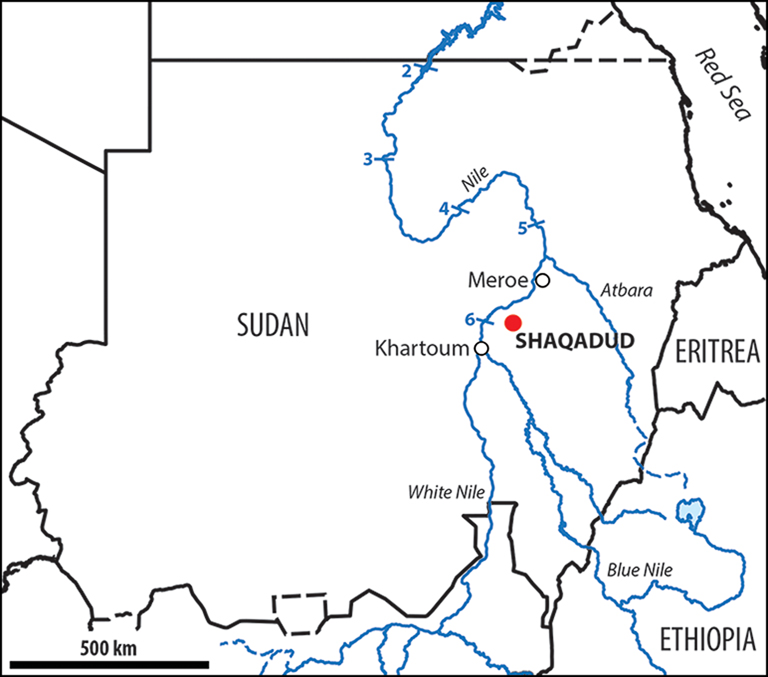
Figure 1. Location of the Shaqadud Mountains (map by L. Varadzinová).
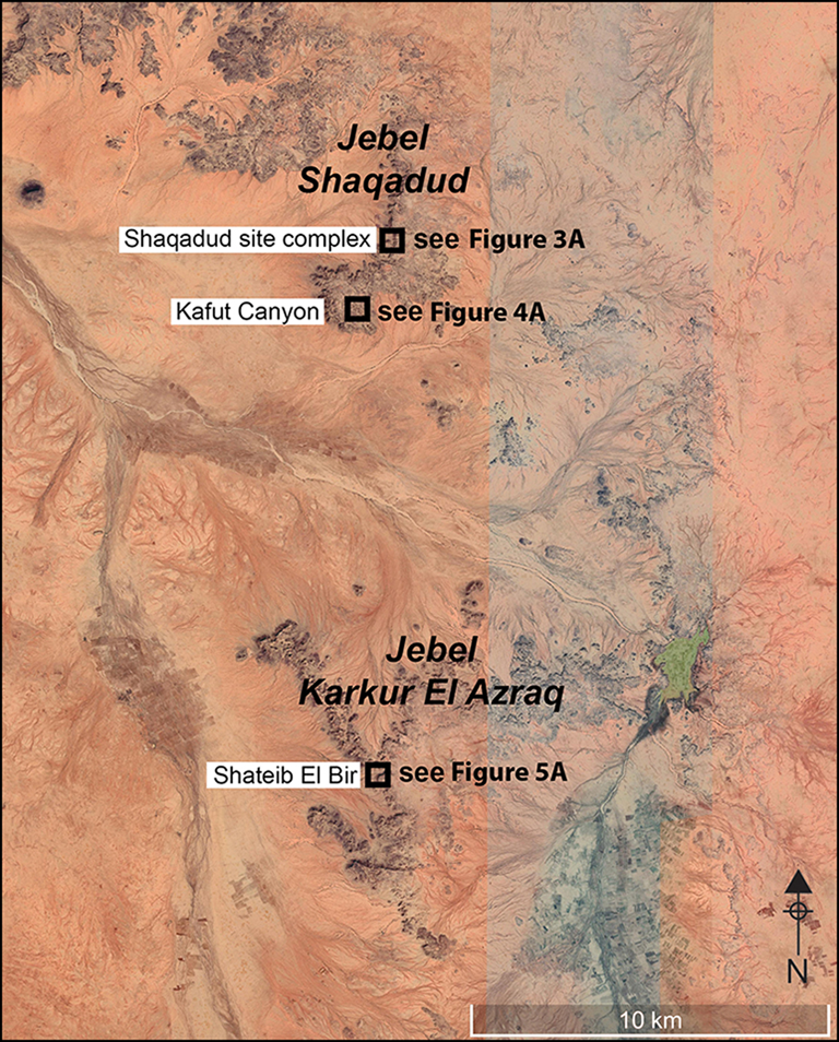
Figure 2. Map of the Shaqadud and Karkur El Azraq mountains showing the sites mentioned in the text (map by L. Varadzin, data from Google Earth 2022).
Following our initial investigations in 2018 (Varadzin et al. Reference Varadzin, Varadzinová, Fuller and Hamdeen2019), we conducted two field campaigns in the Shaqadud region in 2021 and 2022. This article presents some of our initial results.
Shaqadud site complex
At the main site at Shaqadud (Figure 3), the first prehistoric rock art in the region was found near the box canyon, representing giraffes and other wild animals (Figure 3B). At the bottom of the canyon (site S1-B), where the remains of settlement mounds are found, we excavated Trench 1 over Otto's unfinished trench (Figure 3A, C & D); this was divided into five 1 × 1m squares and reached a maximum depth of 2.5m. Trench 1 revealed 18 distinct archaeological layers (Figure 3D), including evidence of tufa deposits from nearby springs and seeps. This depositional sequence rested on a conglomeratic colluvial layer containing some artefacts, which, in turn, overlaid a sterile red-brown loamy fossil soil. The archaeological materials recovered included flaked stone artefacts, mammal bones, ostrich eggshell fragments and beads, ground stone tools and their production waste, mollusc shells, charcoal, fragments of bored stones, and pottery. Layer 20, in the lower part of the trench, provided a radiocarbon date on an ostrich eggshell fragment of 10 697–10 521 cal BP at 95.4% confidence (UCIAMS-264398; 9395±20 BP) (all new dates presented here were calibrated in OxCal v4.4.4 (Bronk Ramsey Reference Bronk Ramsey2020), using the IntCal20 Northern Hemisphere calibration curve (Reimer et al. Reference Reimer2020)). This pushes human occupation at the Shaqadud site complex back by more than 2000 years.
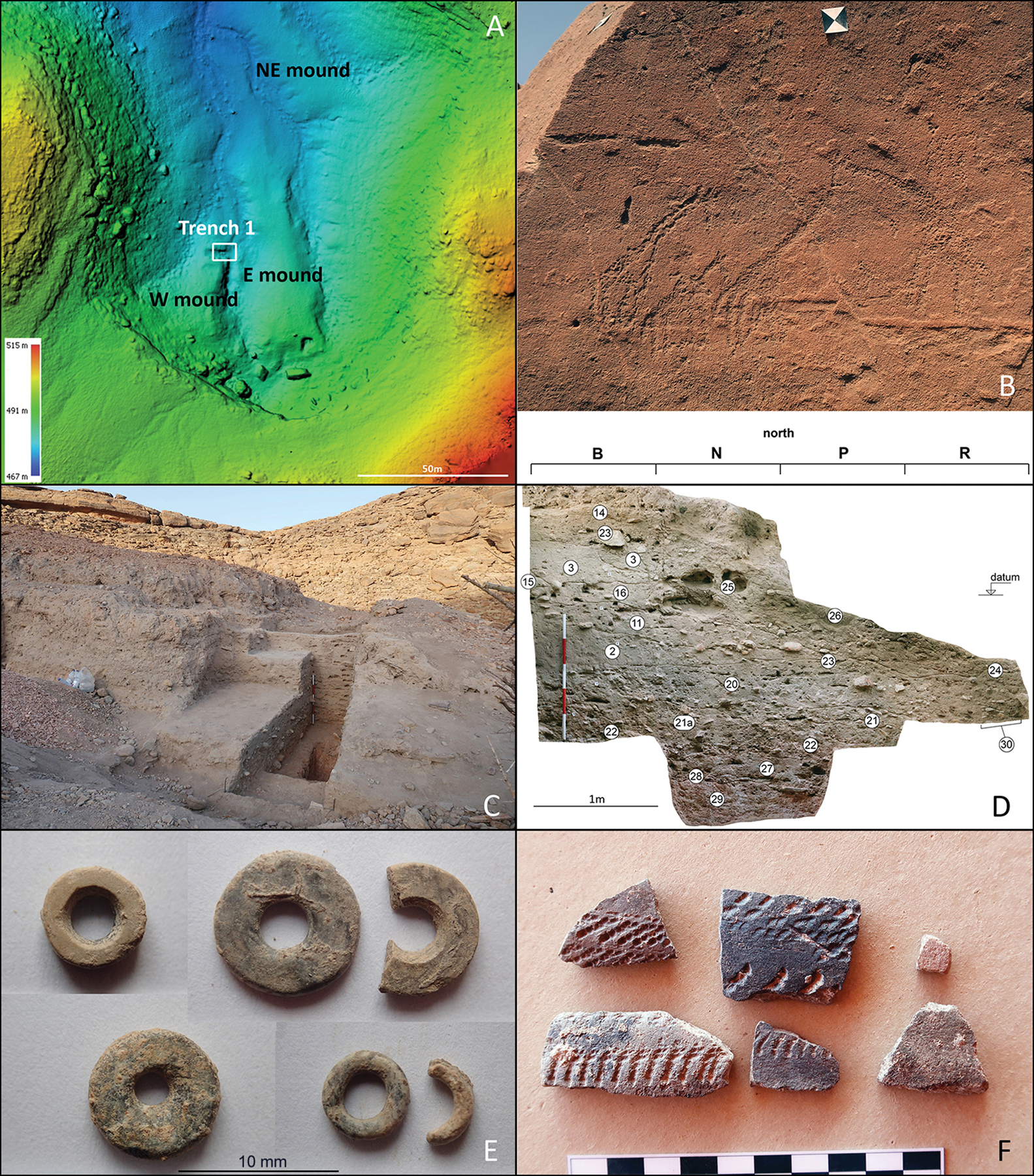
Figure 3. Shaqadud site complex in the box canyon (S1-B): A) digital elevation model of the canyon; B) rock art at Giraffe's Rock; C) Trench 1 after the 2022 excavation; D) orthophotograph of the north profile of Trench 1; E–F) ostrich eggshell beads and pottery from Trench 1 (models by J. Unger, photographs by L. Varadzin).
Kafut Canyon
Kafut Canyon (Figure 2), discovered in 2021 (Figure 4A), is a narrow, 800m-long valley. The cave at its head has entirely collapsed (Figure 4B). Below the cave, relics of tufa and carbonate enriched sediment deposits line the walls of the valley and can be observed in a number of places among the stone rubble. At one such place, Trench 1 (1m2) was excavated to a maximum depth of 0.9m (Figure 4C), revealing nine archaeological layers. The lowest layer comprised pebble and sandstone rubble with some finds, while an in-situ hearth was found roughly 0.45m below the trench surface (Figure 4D). The deposits yielded numerous flaked stone artefacts (mostly on quartz pebbles), faunal remains, ostrich eggshell fragments and beads, mollusc shells, charcoal and ground stone fragments. Despite the large quantity of artefacts, no pottery was recovered from Trench 1, nor from the surface of the valley. Ostrich eggshell fragments from layer five and below provided two radiocarbon dates: 11 745–11 401 cal BP (UCIAMS-264404; 10 060±20 BP) and 11 396–11 246 cal BP (UCIAMS-258123; 9915±20 BP), both at 95.4% confidence. So far, these are the earliest dates from the entire research area.
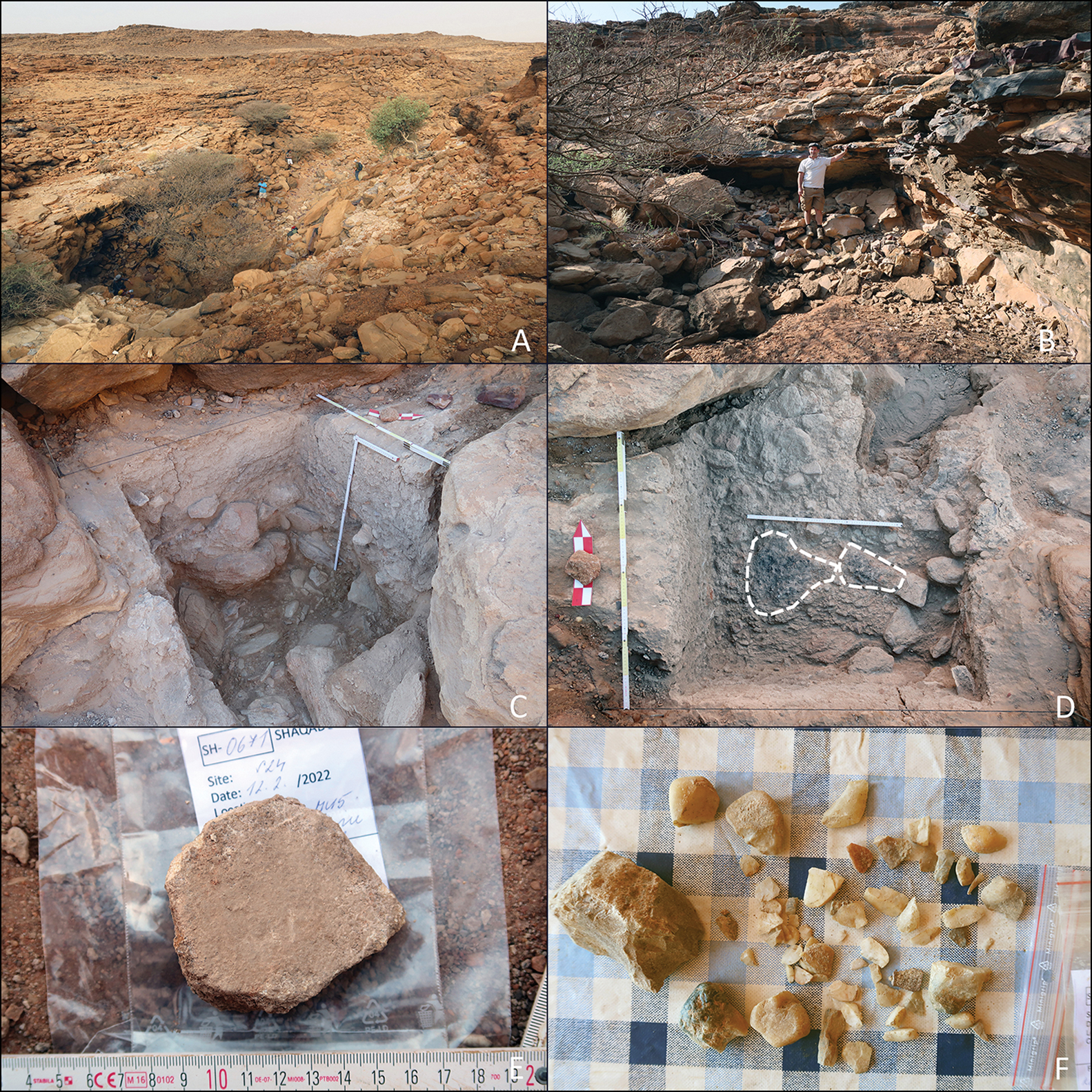
Figure 4. Kafut Canyon (S24): A) general view of site; B) collapsed cave; C) Trench 1 after excavation; D) remains of fireplace in Trench 1; E–F) stone grinding plate and flaked stone artefacts (photographs by L. Varadzin).
Shateib El Bir
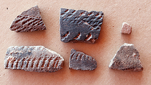
In 2022, we extended our survey to Jebel Karkur El Azraq, a mountain range approximately 10km south of Shaqadud and 50km from the Nile. This area has not been archaeologically investigated previously. Here, we discovered a new site, Shateib El Bir (Figure 5A), located on the floor of a steep-walled canyon, with the western end opening onto a lower plain. Surface survey suggests that the site covered at least 500 × 100m, and it features surprisingly numerous, diverse and well-preserved artefacts, including diagnostic Khartoum Mesolithic, Khartoum Neolithic and Late Neolithic ceramics (Figure 5C–D). At the back of the canyon is an approximately 3.7m-high mound with steep sides. This resembles settlement mounds at Shaqadud S1-B in terms of the character of the sediments and the surface and subsurface finds (Figure 5B). In addition to the cultural material, Shateib El Bir features numerous relics of ancient springs and seeps. Together with the site's area, the spatial configuration, quantity and cultural attribution of the finds suggest that Shateib El Bir closely parallels the Shaqadud site complex.
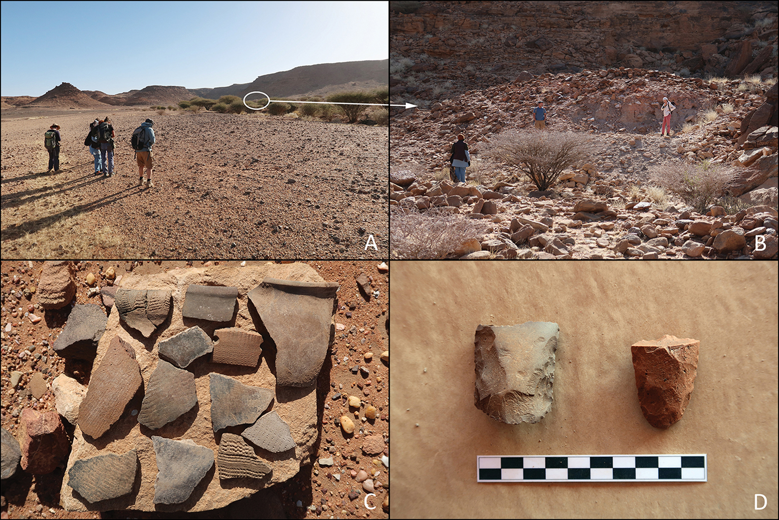
Figure 5. Shateib El Bir (KA1): A) general view of the site; B) mound with archaeological deposits; C–D) surface finds of pottery and flaked stone gouges (photographs by L. Varadzin).
Conclusion
The Shaqadud site complex, renowned for its deep, rich archaeological deposits, is not an anomaly in the Sahel. Our research has uncovered at least one similar site, Shateib El Bir, in north-west Butana. Both sites are closely associated with fossil springs that discharged from the walls of the nearby sandstone mountains and which apparently supported long-term occupation. Our study further suggests that prehistoric occupation of north-west Butana stretches more than three millennia further back than previously known, aligning it with the onset of the Holocene. The early dates from Kafut Canyon also pre-date the oldest postglacial dates from the Nile Valley (leaving aside the earlier refugia around the Second Nile Cataract) by roughly 500 years (cf. Garcea Reference Garcea2020). This indicates that the hinterlands of the eastern Sahel may have been an area of primary postglacial colonisation that parallels or pre-dates well-studied riverine corridors in the Sahara (Drake et al. Reference Drake2011). These early dates come from intact contexts with no evidence of pottery production, indicating an approximately 1000-year long, pre-ceramic early Holocene occupation by hunter-gatherers that has not been identified elsewhere in central Sudan. Exploration of north-west Butana thus has the potential to extend the current panorama of past cultural entities and adaptations in what is today's Sahel and to shed new light on a number of key transitions, such as the earliest ceramics, cultivation and agro-pastoralism.
Acknowledgements
We thank the National Corporation for Antiquities and Museums, Sudan, in particular Abdelrahman Ali Mohamed and Abd El-Hai Abd El-Sawy for their support and help. Special thanks are due to Abbas Mohammad-Ali for his memories and everlasting support.
Funding statement
The research was funded by the Lumina quaeruntur (LQ300022002) award granted to L. Varadzin by the Czech Academy of Sciences. The engagement of L. Varadzinová was made possible thanks to the Programme for the Development of Study at Charles University Cooperationes, section Archeology.


