


Introduction
Absolute chronology building is a fundamental strength of archaeological research, however it has received relatively little attention within investigations of the Inka Empire. Inka chronological references generally still follow the mid-20th reconstruction developed by Rowe (Rowe Reference Rowe1944, Reference Rowe1945) based upon Spanish colonial documents. Discrepancies between this chronological scheme and radiometric data have become increasingly apparent in recent years, however, particularly in the southern portion of the Empire (e.g., D’altroy et al. Reference D’Altroy, Williams, Lorandi, Burger, Morris and Matos Mendieta2007; Cornejo Reference Cornejo2014; Lynch Reference Lynch2012; Schiappacasse Reference Schiappacasse1999; Williams and D’Altroy Reference Williams and D’Altroy1998). Despite this disparity, the production of radiocarbon-based chronological revisions has been hamstrung by the inherent shortcomings of radiocarbon (14C) data, particularly in terms of accomplishing sufficient precision within the narrow temporal window of the Empire (∼AD 1400–1532). With increased research focus archaeologists can and should establish an independent Inka imperial chronology to better understand Inka provincial politics and enhance comparisons with other empires.
While it has infrequently been applied to Inka archaeology, in the last several decades advances in 14C dating and analysis have progressed sufficiently to build prehistoric chronologies at a high precision. The widespread availability of improved 14C laboratory measurement techniques, updated calibration curves, improved sample selection criteria, and custom statistical analysis software have vastly improved the quality of absolute chronologies possible for archaeologists (Hajdas et al. Reference Hajdas, Ascough, Garnett, Fallon, Pearson, Quarta, Spalding, Yamaguchi and Yoneda2021). Analyses applying such tools to date assemblages—with an emphasis on statistical methods—have been used to develop high-precision chronologies for the timing and tempo of colonization of East Polynesia and New Zealand (Bunbury et al. Reference Bunbury, Petchey and Bickler2022; Wilmshurst et al. Reference Wilmshurst, Hunt, Lipo, Anderson and O’Connell2011), Early and Dynastic Egypt (Bronk Ramsey et al. Reference Bronk Ramsey, Dee, Rowland, Higham, Harris, Brock, Quiles, Wild, Marcus and Shortland2010; Dee et al. Reference Dee, Brock, Ramsey, Wengrow, Shortland, Stevenson and Flink2013), and the Early Bronze Age transition in the Levant (Regev et al. Reference Regev, Miroschedji, Greenberg, Braun, Greenhut and Boaretto2012), among many other examples.
Even for the Inka Empire, which may have been in operation for as little as a century, statistical analysis of 14C data assemblages has the potential to provide meaningfully precise chronological information (see for example Burger et al. Reference Burger, Salazar, Nesbitt, Washburn and Fehren-Schmitz2021; Marsh et al. Reference Marsh, Kidd, Ogburn and Durán2017; Ogburn Reference Ogburn2012; Puerto and Marsh Reference Puerto and Marsh2021; Swift et al. Reference Swift, Bahamodes and Schulting2022; Valdez and Bettcher Reference Valdez and Bettcher2022a). This ability is further demonstrated in the following research with an analysis of Inka chronology in the Upper Loa River region of northern Chile’s Atacama Desert, a southern province of the Inka Empire. The Upper Loa River region offers a particularly good context from which to estimate the timing of Inka conquest as it contains several sites firmly associated with Inka rule that have been extensively excavated and have substantial 14C datasets. The methodology employed utilizes Bayesian analysis of 14C datasets within an OxCal 4.4 platform in order to increase their precision (Bronk Ramsey Reference Bronk Ramsey2009a; Bronk Ramsey Reference Bronk Ramsey, Barceló and Bogdanovic2015). As sample context is a major source of concern in such chronologies (Contreras Reference Contreras2022; Ogburn Reference Ogburn2012), we utilize dates only from clear Inka-founded sites without preceding Late Intermediate Period (LIP) occupations to model the onset of Inka control of the region, and compare chronologies of other site types against this estimate as a means of investigating diachronic imperial processes. The aim of both context selection and overall model construction is to reduce the potential for erroneous or low-precision estimates of the onset of Inka political control of the Upper Loa River area.
Background
The traditional chronology and Inka ethnohistory
Spanish intrusion into South America in the 16th century AD brought into the historical record the Inka Empire, an indigenous polity that sprawled out from a capital in Cuzco, modern Peru, to form the largest empire in the pre-Columbian Americas (D’Altroy Reference D’Altroy2015, 2). Despite the Inka’s detailed administrative practices, they appear to have employed no writing system and kept no multi-year calendar, with oral histories instead being passed down without attachment to an annualized age (Bauer Reference Bauer1992). Following Spanish conquest initiated in AD 1532 a variety of chronicles of Inka history were written, often by European sources utilizing native informants who were unaccustomed to using an accounting of years to reckon history (see Cobo Reference Cobo1979 [1653]; Rowe Reference Rowe1945, 276). While chroniclers retroactively applied calendar dates to the oral narratives, this resulted in highly contradictory chronologies of the Empire’s founding and expansion. In reconciling the information into an absolute chronology, John Rowe (Rowe Reference Rowe1944; Rowe Reference Rowe1945) gave priority to Miguel Cabello de Valboa (Reference Cabello de Valboa1951 [1586]) over the later work of Garcilaso de la Vega (Reference De la Vega1609). The analysis overall argues for a beginning of the Empire in just AD 1438 and offers calendar dates associated with major campaigns of expansion discussed in the chronicles (Figure 1). Rowe’s reconstruction has been the most widely referenced since its publication and is notable for the short timeframe allotted to the imperial era. For consistency amid other chronologically oriented research (Marsh et al. Reference Marsh, Kidd, Ogburn and Durán2017; Ogburn Reference Ogburn2012), this chronological scheme is referred to here as the “traditional chronology.”

Figure 1. The extent of the Inka Empire, including the timing and territory conquered by each emperor according to the traditional chronology (after Rowe Reference Rowe1945, 273). The current project area in the Upper Loa River region of northern Chile is also demarcated.
Though widely used, the veracity of the traditional chronology has been debated on purely ethnohistorical grounds. Julien (Reference Julien2008), for example, used the later discovered Incas Nietos document (see Rowe Reference Rowe1985)—as well as her own parsing of the same documents used by Rowe—to suggest that the Ica Valley of southern Peru was actually conquered a full generation earlier than previously thought. As with Rowe’s original chronology, the analysis relies on judging the accuracy of different colonial documents and how they should be interpreted. Ogburn (Reference Ogburn2012) argues that the chronicles are fundamentally misinterpreting testimonies regarding Inka conquests as being ordered chronologically, when native sources were actually ordering them geographically. This would render many of the details of the traditional chronology invalid. Others more generally disregard the ethnohistoric documents as being wholly unsuited for a literal historical reading, instead suggesting they are akin to mythologies (e.g., Meyers Reference Meyers2016; Zuidema Reference Zuidema1982). These of course are disparate perspectives on Inka ethnohistory, that range from slight modifications of the traditional chronology to largely disregarding their chronological information. As the addition of new documentary data is rare, it is difficult to test one perspective over another; revisions based upon ethnohistoric documentation alone are unlikely for the foreseeable future.
Radiometric conflicts with the traditional chronology
In recent decades 14C data from Inka contexts has deviated sufficiently from the traditional chronology for archaeologists to begin discussing the issue. Based upon archaeological investigation of the Cuzco area, Bauer (Reference Bauer1992) revised the appearance of Inka imperial ceramics in the region back to approximately AD 1400, and this is sometimes used as an approximate start date for the Empire as a whole. Conflicting provincial data is more commonly discussed and is ubiquitous in the southern provinces. Pärssinen and Siiriäinen (Reference Pärssinen and Siiriäinen1997) raised early chronological questions based upon 14C dates from Tiquischullpa in the Lake Titicaca area, though they suggested that 14th century dates may just reflect arrival of Inka-style ceramics and not imperial conquest. Date assemblages from Inka sites in southern Bolivia also appear early (Alconini Reference Alconini2002; Meyers Reference Meyers2016; Pärssinen Reference Pärssinen2015), with Pärssinen (Pärssinen Reference Pärssinen2015, 280) arguing for Inka conquest of the Altiplano and southern Bolivia areas in the first half of the 15th century. The accumulation of data from Bolivia, Argentina, and Chile by the 2000s similarly led D’Altroy and colleagues (D’Altroy et al. Reference D’Altroy, Williams, Lorandi, Burger, Morris and Matos Mendieta2007; see also Williams and D’altroy Reference Williams and D’Altroy1998) tentatively to propose Inka conquest of these areas in the first half of the 15th century instead of post-1471. These references and many more agree that Inka arrival occurred prior to supposed in the traditional chronology (Berenguer Reference Berenguer2007; Lynch Reference Lynch2012; Santoro et al. Reference Santoro, Williams, Valenzuela, Romero and Standen2010; Uribe and Sánchez Reference Uribe and Sánchez2016; Valdez and Bettcher Reference Valdez and Bettcher2022b, 240–241), though each local chronology is based upon a small number of 14C measurements which are not given in-depth sampling or statistical considerations.
As 14C and ceramic thermoluminescence (TL) measurements from Inka contexts have accumulated, attempts have been made to analyze them in aggregate to form broader chronologies. Adamska and Michecsynski’s (Reference Adamska and Michcszynski1996) early chronology from Peru is characterized by the large error ranges in measurements common at the time, but largely matched the traditional chronology. Schiappacasse soon after (Reference Schiappacasse1999) analyzed 14C and TL dates mostly from northern Chile, concluding that while some measurements are unrealistically old the frequency of such “old” dates necessitated consideration of Inka arrival in Chile as early as the 14th century (Schiappacasse Reference Schiappacasse1999, 139). Such suggestions have been a common theme of most analyses. Also focusing on Chile, Cornejo (Reference Cornejo2014) analyzed 59 14C and 214 TL dates from Inka-associated contexts, parsing the data into different regions. Cornejo ultimately argued that the cumulative probability curves aggregating the two types of measurements indicated Inka imposition beginning in AD 1370 in the semi-arid north of Chile (north of modern Santiago)—a full century earlier than the traditional chronology—as well as AD 1380 in the Atacama region, AD 1390 in central Chile (in the region of Santiago), and AD 1410 in Tarapacá.
Several recent studies have found similarly early dates for Inka arrival at what would become their far southern frontier. Marsh and colleagues (Marsh et al. Reference Marsh, Kidd, Ogburn and Durán2017) evaluated all Inka dates from northwest Mendoza, Argentina (the southeastern Inka frontier) using Bayesian statistical modeling. This sample included 26 14C and 19 TL measurements from contexts with Inka ceramics or Inka architecture. The authors argued that the Inka occupation began between AD 1350–1440, a particularly notable result as the area is one of the most distant regions conquered yet has a probability distribution skewing mostly prior to the imperial era is thought to have begun. However, Puerto and Marsh (Reference Puerto and Marsh2021)—utilizing Bayesian models of 91 absolute dates—found a similar beginning of Inka imposition in central Chile by the late 14th century, as did Swift and colleagues’ (Swift et al. Reference Swift, Bahamodes and Schulting2022, 1229–1232) Bayesian modeling of a multi-component cemetery at Estadio de Quillota in the same region. The latter cemetery analysis centers upon eight dated burials of human bone collagen from “Late Period contexts,” based upon the presence of local ceramic traditions with Inka stylistic influences.
While many extant studies point to a late 14th century Inka arrival throughout even the furthest southern reaches of the Empire, there are reasons to treat these results with some caution. One significant factor is the use of TL dates in these analyses, which appear to skew estimates toward older ages. At issue here is both what an Inka-associated ceramic can be assumed to reflect in terms of exchange or stylistic influence as opposed to conquest (see Pärssinen and Siiriäinen Reference Pärssinen and Siiriäinen1997; Santoro et al. Reference Santoro, Williams, Valenzuela, Romero and Standen2010), as well as an apparent tendency toward aberrant dates from TL assemblages in the study area. Marsh and colleagues (Marsh et al. Reference Marsh, Korpisaari, Puerto Mundt, Gasco and Durán2021) went on to study the accuracy of southern Andean TL measurements using different techniques in comparison to associated 14C dates and concluded that, “…luminescence dates are not reliable enough for constructing or revising cultural chronologies” (Marsh et al. Reference Marsh, Korpisaari, Puerto Mundt, Gasco and Durán2021, 1495). Analyses of Argentinian data excluding TL dates have offered more moderate refinements of Inka conquest (García Reference García2021; García et al. Reference García, Moralejo and Ochoa2021; Ziółkowski et al. Reference Ziółkowski, Pawlyta, Sieczkowska and Rakowski2022), though these also rely on low-resolution measurements and in some circumstances utilize sample grading criteria that may be difficult to standardize.
Overall, protocols for screening radiometric dates against quality criteria and eliminating those found deficient from further analysis—sometimes termed “chronometric hygiene” (Spriggs Reference Spriggs1989)—are in their early stages in Inka chronological studies. Such protocols have often been discussed by archaeologists seeking to determine the age of past island colonization events (e.g., Athens et al. Reference Athens, Rieth and Dye2014; Dye Reference Dye2015; Fitzpatrick Reference Fitzpatrick2006; Napolitano et al. Reference Napolitano, DiNapoli, Stone, Levin, Jew, Lane, O’Connor and Fitzpatrick2019; Rieth Reference Rieth2007). Most of these methods are designed to control for issues of inbuilt age and provenience, frequently screening out well over half of published dates. Problematically, as absolute chronology has been of minor importance in Inka studies, producing radiometric data in accordance with these methodologies has not become standard procedure. Applying some of the common protocols, such as dating only short-lived plant species or terrestrial animal bone identified to taxon with thoroughly published provenience information (e.g., Wilmshurst et al. Reference Wilmshurst, Hunt, Lipo, Anderson and O’Connell2011), for example, could eliminate almost the entire corpus of published dates for many Inka sub-regions.
Ogburn’s (Reference Ogburn2012) analysis of a single Inka military outpost in southern Ecuador (refined in Marsh et al. Reference Marsh, Kidd, Ogburn and Durán2017) is one Inka chronological model largely unaffected by problems of chronometric hygiene. The analysis focuses upon a sample of seven relatively precise 14C dates to build a Bayesian phase model of the Inka outpost of Chamical, a structure clearly associated with the advance of the Inka army and built atop previously unoccupied land. Endemic problems of stratigraphic intermixing with earlier occupations are altogether avoided, and the author concludes that Inka occupation at Chamical likely began just 10–20 years prior (∼ AD 1445) to the dates indicated in the short chronology (updated calibrations by Ancapichún et al. Reference Ancapichún, Pawlyta, Rakowski and Sieczkowska2022 and Ziółkowski et al. Reference Ziółkowski, Pawlyta, Sieczkowska and Rakowski2022 place this event even closer to the traditional chronology). Similar in-depth radiocarbon chronologies of individual Inka-founded sites have also been done for the royal estate of Machu Picchu in the Urubamba area as well as the provincial center of Tambo Viejo on the Peruvian coast. These assemblages demonstrate convincingly that Machu Picchu and nearby sites were already in use by the Inka in the first half of the 14th century (Burger et al. Reference Burger, Salazar, Nesbitt, Washburn and Fehren-Schmitz2021; Ziółkowski et al. Reference Ziółkowski, Abuhadba, Hogg, Sieczkowska, Rakowski, Pawlyta and Manning2021, Reference Ziółkowski, Pawlyta, Sieczkowska and Rakowski2022), and that Tambo Viejo was also likely founded much earlier in the 1400s than allowed by the traditional chronology (Valdez and Bettcher Reference Valdez and Bettcher2022b, 24). Expanded studies using similar methodologies may provide an economical and reliable way to chart imperial expansion and cross-check past estimates in future research.
The Upper Loa River region under Inka rule
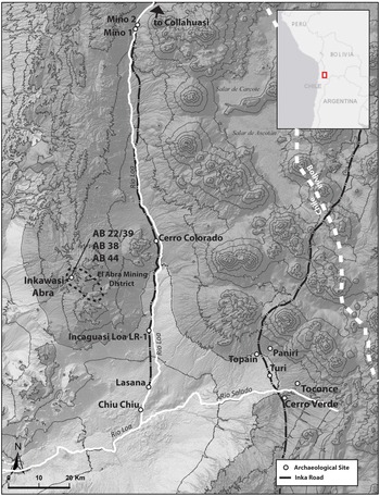
In the present work we focus upon Inka chronology of the Upper Loa River area of northern Chile’s Atacama Desert. The Atacama is characterized by hyper-aridity, with populations during the Late Intermediate Period (LIP, ∼AD 1000–1400) concentrated in small zones with reliable sources of surface water and pasturelands such as the high-elevation Upper Loa River region and the Salar de Atacama oases (Figure 2). Like other Andean regions (Covey Reference Covey2008), the LIP in the Atacama shows a shift in settlement patterns from dispersed hamlets to agglutinated villages placed in elevated locations (Aldunate and Castro Reference Aldunate and Castro1981; Urbina Reference Urbina2010). This change was concomitant with the expansion of irrigated agricultural systems that canalized spring discharge and terraced slopes along surface waterways (Adán and Uribe Reference Adán and Uribe2005). Camelid pastoralism was essential for subsistence production, as well as the transport of goods across interregional trade nodes (Núñez and Dillehay Reference Núñez and Dillehay1979; Berenguer Reference Berenguer2004).

Figure 2. The Upper Loa River area with archaeological sites discussed in the text.
Colonial documents for the area are very few until the 17th century (Martínez Reference Martínez1998), however archaeological signatures of Inka rule are abundant (Salazar et al. Reference Salazar, Berenguer, Castro, Hayashida, Parcero-Oubiña, Troncoso, Hayashida, Troncoso and Salazar2022). In the southern Andes in general the scale of Inka infrastructure is smaller than in the central Andes, reflecting an adaptation to the size of indigenous populations and not necessarily a lack of imperial interest in direct rule (Santoro et al. Reference Santoro, Williams, Valenzuela, Romero and Standen2010; Williams et al. Reference Williams, Santoro, Romero, Gordillo, Valenzuela and Standen2009). In the Upper Loa River at least two branches of the Inka imperial road system and attendant way stations were extended through the region (Berenguer et al. Reference Berenguer, Cáceres, Sanhueza and Hernández2005; Castro et al. Reference Castro, Varela, Aldunate and Araneda2004), local sacred peaks were built upon with Inka shrines (Ibacache et al. Reference Ibacache, Cantarutti, Berenguer and Salazar2016), and programs for expanding agricultural production and greenstone (copper minerals and turquoise) extraction were instituted (Uribe et al. Reference Uribe, Adán and Agüero2002; Adán and Uribe Reference Adán and Uribe2005; Salazar Reference Salazar2008; Salazar et al. Reference Salazar, Berenguer and Vega2013a; Berenguer and Salazar Reference Berenguer and Salazar2017). These activities were orchestrated from several administrative centers, of which the mixed Inka-local settlement of Turi at 4 hectares was the largest and likely of regional importance (Raffino Reference Raffino1981; Castro et al. Reference Castro, Maldonado and Vásquez1993; Uribe Reference Uribe1999; Aldunate et al. Reference Aldunate, Castro and Varela2003; Berenguer and Salazar Reference Berenguer and Salazar2017). The site contains a large formal plaza, adobe kallanka, and megalithic perimetral wall that may be considered political monumental architecture (Castro and Cornejo Reference Castro and Cornejo1990; Castro et al. Reference Castro, Maldonado and Vásquez1993; Gallardo et al. Reference Gallardo, Uribe and Ayala1995; Cornejo Reference Cornejo1999).
Other administrative bases, such as Miño 1, Miño 2, Cerro Colorado, and Cerro Verde were built by the Inka upon unoccupied land (Berenguer Reference Berenguer2007; Salazar et al. Reference Salazar, Berenguer, Castro, Hayashida, Parcero-Oubiña, Troncoso, Hayashida, Troncoso and Salazar2022). These are termed here as ‘Inka-founded imperial sites’, which were typically placed to administer nearby greenstone mining operations. These are characterized by formal Inka architecture such as kallanka administrative buildings, ushnu ceremonial platforms, and kancha or plaza spaces used for state ritual and hospitality (Adán Reference Adán1999; Adán and Uribe Reference Adán and Uribe2005; Uribe and Urbina Reference Uribe and Urbina2009; Salazar et al. Reference Salazar, Berenguer and Vega2013a; Berenguer and Salazar Reference Berenguer and Salazar2017; Salazar et al. Reference Salazar, Berenguer, Castro, Hayashida, Parcero-Oubiña, Troncoso, Hayashida, Troncoso and Salazar2022). Several pre-existing local population centers, such as Lasana and Chiu Chiu, continued in operation during Inka rule and presumably provided labor and expertise in local mining operations (Berenguer Reference Berenguer2007). Many additional sites have been chronologically less resolved due to lack of research but perhaps can be linked to Inka activities in various ways. These include the large irrigated agricultural systems at Toconce, Topaín, and Paniri, miscellaneous mining infrastructure, mountain shrines lacking culturally distinctive architecture, and llama caravan trails among other examples (Adán and Uribe Reference Adán and Uribe2005; Parcero-Oubiña et al. Reference Parcero-Oubiña, Fábrega-Álvarez, Salazar, Troncoso, Hayashida, Pino, Borie and Echenique2017).
According to the traditional chronology the Atacama area is estimated to have been subdued via a military campaign through Bolivia and Chile by Pachacuti’s son, Topa Inka, after his accession to the throne ca. AD 1471 or 1473 (Rowe Reference Rowe1945, 271; see Figure 1). Formal analyses of Inka chronology covering data from the Loa were done in 1999 (Schiappacasse Reference Schiappacasse1999) and 2014 (Cornejo Reference Cornejo2014) suggesting earlier imperial expansion into the Atacama. However, since this time updated calibration curves have been released, statistical software has become more advanced, and additional 14C data has become available from a variety of site types in the region.
Methods and models
In order to build a chronological model of Inka rule in the Upper Loa 14C dates from Inka contexts were screened against a simple “hygiene” protocol and Bayesian modeled within OxCal (Bronk Ramsey Reference Bronk Ramsey1995; Bronk Ramsey Reference Bronk Ramsey2009a). Radiocarbon measurements are compared against a dendrochronologically-based calibration curve and expressed as 68% or 95% highest posterior density (hpd) ranges that individually tend to have low resolution (Bronk Ramsey et al. Reference Bronk Ramsey, Dee, Rowland, Higham, Harris, Brock, Quiles, Wild, Marcus and Shortland2010). Applying Bayes’ theorem allows for the incorporation of prior information into the calibration process—such as the stratigraphic ordering of multiple measurements or known calendar dates of site abandonment—and the calculation of refined posterior probability distributions (Bronk Ramsey Reference Bronk Ramsey, Barceló and Bogdanovic2015). Apt incorporation of archaeological context can greatly increase the precision of posterior probability distributions and estimate the absolute timing of events that are not directly measured, such as the founding or abandonment of an archaeological site or the transition between archaeological phases (Dee et al. Reference Dee, Brock, Ramsey, Wengrow, Shortland, Stevenson and Flink2013).
The primary sample screening method employed is based on the perception that continuously occupied LIP-Inka sites are poorly suited to dating the onset of Inka rule (Ogburn Reference Ogburn2012). These sites tend to have ‘palimpsest’ strata bridging the LIP and Inka time periods (e.g., Greco and Otero Reference Greco and Otero2016), residual carbon or intrusive Inka ceramics are likely to impact estimates, and if the initial appearance of an Inka period ceramic component is accurately dated this does not clearly equate to Inka rule. To mitigate these issues in building chronological models, available dates were simply screened for provenience from clear Inka-founded sites—that is clear Inka government contexts such as imperial infrastructure or administrative sites not built atop or within an LIP occupation—with a high bar for any exceptions. Capacocha sacrificial offerings, building materials for Inka buildings installed in LIP sites (e.g., mortar or adobe inclusions), or organic materials found in such sites that are in themselves closely associated with Inka governance (e.g., khipu) are a few examples of potential such exceptions. The protocol largely uses the founding of imperial sites with clear Inka architecture as a proxy for the onset of Inka rule. The resulting dataset for the Upper Loa consists of 34 14C measurements. Additional sorting criteria, such as problematic or “outlier” dates, were mostly identified and addressed within OxCal, though in some instances (described below) particularly low-precision dates were simply dismissed for their poor information potential.
Bayesian modeling was executed within OxCal 4.4 utilizing the SHCal 20 calibration curve for the Southern Hemisphere (Hogg et al. Reference Hogg, Heaton, Hua, Palmer, Turney, Southon, Bayliss, Blackwell, Boswijk and Ramsey2020). Posterior probabilities (modeled date ranges) and associated modeled mean and median dates of these distributions are italicized in the text, and all dates used to model the onset of Inka rule are reproduced in tables. Median calendar dates of hpd ranges are frequently referenced to facilitate comparison between models, however it is important to keep in mind that these dates represent only approximations of larger probabilistic distributions, each of which vary in terms of the strength of their underlying data. Alternative models are presented in some cases in order to gauge the impact of different model priors upon results, and additional models (not from clear Inka-founded sites) are produced in order to inform relevant diachronic patterns. All models ran successfully with acceptable agreement indices, and the complete model code employed is included as supplementary data.
Modeling Inka conquest of the Upper Loa River region
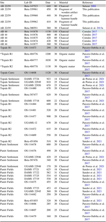
The 14C -dataset from Inka imperial sites without immediately preceding occupations currently consists of 34 measurements from four sites (Table 1). The assemblage comes from the administrative centers of Miño 1 (4 dates) and Miño 2 (12 dates), the mining center of Inkawasi Abra within the El Abra constellation of mining sites (14 dates), and Incaguasi Loa LR-1, a way station built along the Inka Road (4 dates). Note that one date from an organic inclusion of the adobe bricks of the kallanka at Turi also meets our context criteria, however was excluded from our models as the measurement has an exceedingly high error range of ± 150 and the author suspected contamination (Aldunate Reference Aldunate1993, p. 67).
Table 1. All dates from Inka-founded sites or Inka building materials in local sites

Shaded = identified as outlier,
*= meets context criteria but excluded from models due to low precision.
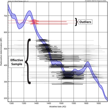
A single-phase model of all dates from the Inka imperial sites without evidence for preceding LIP occupations was first conducted using a General Outlier analysis in order to identify anomalous age measurements (Bronk Ramsey Reference Bronk Ramsey2009b). The only a priori archaeological information in such a model is that all dates come from the same archaeological phase and thus should reflect a degree of internal cogency in their age distributions, and all measurements have an equal (5%) probability of being statistical outliers. The analysis identified the two oldest dates (DAMS 104915/014916), both from Inkawasi Abra, as significant outliers relative to the rest of the assemblage (18% and 20% probability, respectively). These samples could feasibly date an early occupation with a reversed portion of the calibration curve skewing their hpd ranges, however more sample measurements close to their ages would be needed to establish this. Currently their probability distributions significantly predate an otherwise cohesive assemblage, suggesting that inaccurate measurement, an old wood issue, or other unknown sources of error are more likely to blame. These statistical outliers were removed and the model was re-run (following Bronk Ramsey Reference Bronk Ramsey2009b: 1024), with the remaining group of 32 dates constituting the effective sample for estimating Inka conquest (Figure 3). In precise terms the “start” boundary for the resulting phase model is a chronological estimate for the first occupation or founding of these sites, however this metric is used here as a proxy for the onset of Inka rule. The results place the start of this event between AD 1411–1430 (68% hpd; median AD 1420) or AD 1401–1437 (95% hpd range).

Figure 3. Outlier model of 14C dates from Inka founded sites (n = 34) plotted on the ShCal20 Calibration Curve (Hogg et al. Reference Hogg, Heaton, Hua, Palmer, Turney, Southon, Bayliss, Blackwell, Boswijk and Ramsey2020). Light fill represents unmodeled probability distributions while dark fill is posterior (modeled) distributions.
The model output provides one of the most precise 14C-based estimates of Inka annexation available, and several different model iterations were run with different inputs in order to evaluate the impact of different parameters on the results (Table 2). Leaving the two excluded outliers in the model pushes back the start estimate drastically, to a median start estimate of AD 1386, demonstrating the large impact a small number of outlier dates can have on model estimates. Charcoal Models were also substituted for the General Outlier model. While General Outlier models generally assign every sample an equal 5% probability of being an outlier, a Charcoal Model assumes that samples identified simply as “charcoal” or “wood” (as opposed to a specific short-lived plant) have increased old wood liability and biases their posterior distributions towards younger ages (Dee and Ramsey Reference Dee and Ramsey2014). Applying a Charcoal Model to the sample with outliers included essentially interprets the outliers as having significant inbuilt age and moves the model to a median date of AD 1413. A version excluding the general outliers and applying a Charcoal Model to the 32-date effective sample tightens the 68% hpd range to AD 1414–1431 with a median date of 1422. We interpret the close coherence of the latter Charcoal Model with our primary model as an indication that inbuilt age is of little impact to our effective sample but may be a significant factor for the identified outliers. In interpretations we utilize our results with general outliers removed and no charcoal model applied as it eliminates errant samples from skewing results but otherwise makes fewer assumptions regarding sample deposition.
Table 2. Modeled dates for the start of the Inka Phase in the Upper Loa. The shaded row is the authors’ primary interpretive model with results from slightly different inputs also displayed

Shaded = authors’ primary interpretive model;
*OxCal Agreement Index measuring model cogency.
Selection of calibration curve is also an important factor in some areas of the Andes as issues of inter-hemispheric air mixing could impact 14C measurements to unclear degrees (Ogburn Reference Ogburn2012; Marsh et al. Reference Marsh, Bruno, Fritz, Baker, Capriles and Hastorf2018; see also Contreras Reference Contreras2022). Since the discovery that atmospheric 14C cycling differs between hemispheres custom Southern Hemisphere calibration curves have been constructed and updated with new data (e.g., McCormac et al. Reference McCormac, Reimer, Hogg, Higham, Baillie, Palmer and Stuiver2002; Hogg et al. Reference Hogg, Hua, Blackwell, Niu, Buck, Guilderson, Heaton, Palmer, Reimer and Reimer2013). In the absence of site-specific atmospheric modeling (e.g., Ancapichún et al. Reference Ancapichún, Pawlyta, Rakowski and Sieczkowska2022), the Loa area’s position south of the Intertropical Convergence Zone (ITCZ) as usually mapped makes the SHCal20 curve the appropriate choice (Hogg et al. Reference Hogg, Heaton, Hua, Palmer, Turney, Southon, Bayliss, Blackwell, Boswijk and Ramsey2020, 773), and the area does not show the tropical climate pattern in particular need of additional data (Marsh et al. Reference Marsh, Bruno, Fritz, Baker, Capriles and Hastorf2018). For heuristic purposes, applying a mix of the SHCal20 curve and IntCal20 curve for the Northern Hemisphere, which has been recommended for areas within the ITCZ (Hogg et al. Reference Hogg, Heaton, Hua, Palmer, Turney, Southon, Bayliss, Blackwell, Boswijk and Ramsey2020; Marsh et al. Reference Marsh, Bruno, Fritz, Baker, Capriles and Hastorf2018), would shift model results backwards to a median date of AD 1410. Ancapichún and colleagues’ (Ancapichún et al. Reference Ancapichún, Pawlyta, Rakowski and Sieczkowska2022) atmospheric modeling also found complex variability in air parcel mixing that does not correspond to the ITCZ geographic limit. To better gauge the scope of potential statistical impacts unique air parcel movement could create a model utilizing only the IntCal20 curve was also run, but this revised the median date to just AD 1405. Based upon current trends if updated atmospheric maps were to unexpectedly impact the project area, they appear unlikely to shift model results more than about 10 to 15 years.
Inka-founded site individual chronologies
Disaggregating the 32-date effective sample by site allows for some detail to be observed regarding the imperial process. In producing an overlapping phase model in which dates from each site are given their own “phase” within the larger Inka phase chronological models were produced for each individual Inka installation. Below a brief overview of the context of each of these sites is provided in conjunction with their modeled founding dates. Results at the 95% hpd range are particularly broad for such site-level models with smaller sample sizes, and estimates are thus frequently discussed at the 68% hpd range in order to facilitate comparison, however it should nonetheless be noted that this hpd range is substantially lower in statistical confidence.
Miño 1 and Miño 2 are located in the northern reaches of the study area, near the headwaters of the Loa River. The sites consist of approximately 36 structures each, separated by about 500 m, and they likely served complementary functions (Berenguer Reference Berenguer2007; Berenguer et al. Reference Berenguer, Cáceres, Sanhueza and Hernández2005; Uribe and Urbina Reference Uribe and Urbina2009). The sites include formal plazas and kallankas (Berenguer Reference Berenguer2007). Similar to the administrative base of Cerro Colorado to the south, the area is agriculturally unproductive and the centers appear built to carry out state business and ceremonies linked to the Inka road and nearby mining operations (Berenguer Reference Berenguer2007; Salazar et al. Reference Salazar, Berenguer and Vega2013a; Varela Reference Varela1999). With 12 relatively high precision 14C dates, Miño 2 is the better dated of the two sites and currently among the better dated single-occupation Inka provincial sites in the empire. The model provides a founding estimate for the site between AD 1405–1435 (68% hpd; median date AD 1419). Miño 1 has just four dates, however all are relatively precise and consistent providing a founding estimate of AD 1405–1446 (68% hpd; median date 1421). Considering the proximity of the Miño locales it would not be surprising if they were constructed simultaneously, explaining their close agreement in founding date estimates.
Inkawasi Abra is a mining camp built during Inka times to house miners and associated workers extracting turquoise and chrysocolla from a nearby mine (Salazar et al. Reference Salazar, Borie and Oñate2013b; Salazar et al. Reference Salazar, Berenguer, Castro, Hayashida, Parcero-Oubiña, Troncoso, Hayashida, Troncoso and Salazar2022). The site is located 100 km to the south of the Miño sites and, unlike those, is more than 25 km to the west of one of the main Inka Roads in Atacamenian territory (Berenguer et al. Reference Berenguer, Cáceres, Sanhueza and Hernández2005). The site is connected to the Inka road and larger administrative centers to the east via llama caravan trails, though the exact route is yet to be determined (Garrido and Salazar Reference Garrido and Salazar2017). The site shows clear Inka building techniques, a formal plaza, and artifacts suggestive of Inka commensal politics (Salazar et al. Reference Salazar, Borie and Oñate2013b). The assemblage of 12 radiocarbon dates (not including two outliers) gives a founding estimate of AD 1405–1440 (68% hpd; median date 1420).
Lastly, Incaguasi Loa LR-1 is an arrangement of 16 structures situated above the Loa River, at a crossroads between the Inka Road running north-south and a passage or “bajada” down into the steep-walled river canyon to the east. The installation is thought to have served a role as a service station of sorts for llama caravans traveling the Inka Road (Berenguer et al. Reference Berenguer, Cáceres, Sanhueza and Hernández2005; Berenguer Reference Berenguer2007). The site layout was changed through later historic uses but still shows clear Inka architectural signatures, and excavations confirmed its founding during the Inka Period (Berenguer Reference Berenguer2007). While the available assemblage consists of just four dates of low precision, the samples come from basal occupation layers and are consistent enough to provide an initial estimate of site founding. The modeled estimate ranges from AD 1413–1493 (66.8% hpd) with a median date of 1456. The model is impacted by low resolution and reversals in the calibration curve, pushing the ranges of dates that likely belong to the 15th century into the 17th century. In a test limiting founding estimates to dates prior to 1550 (18 years after the onset of Spanish conquest), the median date estimate and 68% hpd range change little, however, suggesting that a mid-15th century founding of the site is the most likely scenario.
The overlapping phase model shows very consistent estimates for the founding of Miño 1, Miño 2, and Inkawasi Abra (Table 3). Each 68% hpd range lies between AD 1405 and AD 1435–1446, with median dates between AD 1419 and AD 1421. This suggests that these larger administrative bases and mining camp were all built within a short time span, possibly in a coordinated expansion of administrative and mining activities in the region, with median start estimates centered around AD 1420. The assemblage for Incaguasi Loa LR-1, on the other hand, has lower resolution but skews generally younger than the other sites, indicating that this smaller way station along the Inka Road was added by the Inka some decades later, perhaps reflecting the development of an increasingly thorough infrastructure apparatus over time.
Table 3. Inka Phase and Individual Inka Site Founding Estimates from Overlapping Phase Model

Comparing other Loa site chronologies to the era of Inka rule
Our chronological model leverages dates from Inka-founded sites into a high-resolution estimate for the onset of Inka rule in the Upper Loa of ca. AD 1420 (68% hpd cal AD 1411–1430; 95% hpd 1401–1437). Many sites are not Inka planned, or not clearly so based upon preserved architecture, but determining their patterns of use may still be relevant to understanding Inka imperial processes. Here we use our estimate for the onset of Inka rule as a point of comparison for proposing a new understanding of several of these sites in the Upper Loa area and their relation to Inka rule. Currently available 14C data make this worthwhile for two clusters of sites: additional mining infrastructure within the El Abra site constellation and the agricultural/residential sites of Topaín and Paniri in the Upper Rio Salado (Table 4).
Table 4. 14C dates used in additional site-level models. Shaded rows indicate samples identified as outliers in site-level General Outlier analysis and removed from the final model. *Indicates measurement removed due to apparent systematic bias in bulk sediment samples

The El Abra site constellation
The El Abra area is an extensive district of prehistoric greenstone mining activity expanded greatly during Inka rule (Salazar Reference Salazar2008; Salazar et al. Reference Salazar, Borie and Oñate2013b, Reference Salazar, Berenguer, Castro, Hayashida, Parcero-Oubiña, Troncoso, Hayashida, Troncoso and Salazar2022). In addition to Inkawasi Abra, discussed previously, the sites designated AB 44 and AB 22/39 have sufficient 14C date assemblages to provide initial assessments of site founding. AB 44 (5 dates) is interpreted as a satellite camp or control post along the caravan trail connecting the El Abra area to the Loa River zone (Salazar Reference Salazar2008; Garrido and Salazar Reference Garrido and Salazar2017). AB 22/39 (5 dates) is an open cast mining area with several pits, mineshafts and quarries spread over 3000 m2 (Núñez Reference Núñez1999; Salazar Reference Salazar2008; Salazar et al. Reference Salazar, Berenguer and Vega2013a).
In these analyses no assumptions were made regarding the relationship between sites; dates from each site were simply aggregated into their own individual single-phase models. General outlier analysis was executed on each, and the results presented below are from models re-run with the two identified outliers excluded (Beta 141878 from AB 44 and Beta 147523 from AB 22/39). Neither site shows any indication of a historic occupation, and both were given arbitrary termini ante quem of 1590, as the reversal in the calibration curve would otherwise disperse these dates inaccurately well into the historic era.
Model results for AB 44 and AB 22/39 both show construction dates likely postdating the pulse of construction that built Inkawasi Abra and the Miño sites ca. AD 1420. AB 44’s modeled founding estimate is AD 1427–1487 (68% hpd; median date 1453), and AB 22/39’s is AD 1438–1483 (68% hpd; median date 1449). These models are not as well resolved as those for the clear Inka sites discussed previously, which contain larger datasets, but preliminarily indicate that the AB 44 control post or satellite camp and the AB 22/39 open cast mine were added some decades after initial Inka conquest, perhaps in the same pulse of building that saw the construction of Incaguasi Loa LR-1 near the middle of the 15th century. This possibility is interesting considering that both of these sites are part of the same route connecting the El Abra mining area to the villages of Lasana, Chiu-Chiu, and beyond. Some details of the archaeological context of AB 22/39 should be noted here, however. The wooden hammer handles dated for the site come from mining tailings. Slightly smaller, earlier, mining tailings have been documented at the site but have not yet produced organic material for dating. Thus, in the case of AB-22/39 the Bayesian model may technically be more reflective of the timing of site consolidation rather than founding.
Agricultural/residential sites of Topaín and Paniri
The sites of Topaín and Paniri are situated north of the Rio Salado where springs and pasturelands supported larger populations both before and during Inka rule. Both are characterized by preserved spring-irrigated agricultural field systems, approximately 35 hectares at Topaín and 25 hectares at Paniri. Each has an accompanying residential area, as well as huts and corrals interspersed throughout the field systems (Parcero-Oubiña et al. Reference Parcero-Oubiña, Fábrega-Álvarez, Salazar, Troncoso, Hayashida, Pino, Borie and Echenique2017; Urbina Reference Urbina2010). Topaín does not have a perimeter wall but contains elevated hillside and hilltop sections and is thus sometimes termed a defensive settlement or pukara. Based upon architecture and pottery styles Topaín has mostly been associated with the LIP (Ayán and García Reference Ayán and García2015; Urbina Reference Urbina2010) and Paniri with potential LIP, Inka, and colonial occupations, though the residential area is heavily disturbed at Paniri leaving the earliest components less clear (Parcero-Oubiña et al. Reference Parcero-Oubiña, Fábrega-Álvarez, Salazar, Troncoso, Hayashida, Pino, Borie and Echenique2017). Dates for both sites have been produced by recent research dating the agricultural features and to a lesser extent the residential areas (de Porras et al. Reference de Porras, Maldonado, Hayashida, Troncoso, Salazar, Parcero-Oubiña, Castro and Fábrega-Álvarez2021; Parcero-Oubiña et al. Reference Parcero-Oubiña, Fábrega-Álvarez, Salazar, Troncoso, Hayashida, Pino, Borie and Echenique2017; Sandor et al. Reference Sandor, Huckleberry, Hayashida, Parcero-Oubiña, Salazar, Troncoso and Ferro-Vázquez2021).
Of interest in terms of Inka chronology is an apparent transition away from the LIP site of Topaín in favor of Paniri around the time of Inka rule (Parcero-Oubiña et al. Reference Parcero-Oubiña, Fábrega-Álvarez, Salazar, Troncoso, Hayashida, Pino, Borie and Echenique2017). Topaín currently has 18 14C measurements and Paniri 17, though three of Topaín’s dates come from bulk sediments that appear systematically flawed (Parcero-Oubiña et al. Reference Parcero-Oubiña, Fábrega-Álvarez, Salazar, Troncoso, Hayashida, Pino, Borie and Echenique2017, 106). A single-phase model of all Topaín dates was executed with the bulk sediment samples and two general outliers removed (OS-114473 and OS-114608, 61% and 77%, respectively). The resulting date of abandonment is modeled between AD 1434–1469 (68% hpd range) with a median date of 1454. Models separating dates by context suggest that the Topaín settlement was abandoned before the field system, though these models are low in resolution (Table 5). The Paniri assemblage contains no outliers and a phase model estimates a founding of AD 1361–1402 (68% hpd) with a median date of 1380, though multiple intercepts in the calibration curve are skewing this range.
Table 5. Summary of site founding or abandonment estimates

In addition to calibration challenges, these sites are also conceptually difficult to date as the agricultural fields may have different chronological patterns across their spatial extent, and use of the fields could also differ from the residential settlements. Another avenue for examining occupational patterns is in terms of intensity of use as opposed to absolute founding or abandonment dates. Kernel density estimation (KDE) models provide a mechanism for modeling this and also help reduce noise produced by the shape of the calibration curve (Bronk Ramsey Reference Bronk Ramsey2017).
KDE distributions (Figure 4) demonstrate that while Topaín sees initial activity much earlier, its most intense period of use ranges from the mid-14th to mid-15th centuries, with the last event directly measured in the 14C assemblage estimated between cal AD 1430–1450. As noted above, dates from the Topaín hilltop settlement skew earlier (de Porras et al. Reference de Porras, Maldonado, Hayashida, Troncoso, Salazar, Parcero-Oubiña, Castro and Fábrega-Álvarez2021, 10), with the youngest date from this context in the KDE ranging between AD 1388–1425 (71% hpd; DAMS 17718). Neither phase models nor KDE models currently supply the precision possible with some of the other sites discussed, but the patterning suggests that the settlement was depopulated early in the 15th century while the field system continued in use for some time longer, perhaps until around the middle of the 15th century.

Figure 4. Modeled founding estimates and KDE models for sites in the Upper Loa. Darker gray shading extends from median modeled start of the Inka phase (AD 1420) to the historically documented start of Spanish conquest (AD 1532), lighter gray shading begins at the earliest date of the 95% hpd range for the start of the Inka phase (AD 1401). “Start” refers to modeled founding date estimates according to Bayesian phase models. Crosses show median dates for phases and for KDE models indicate the medians for the marginal posterior distributions of each dated event. The green and red distributions within the KDE graphs reflect the first and last event for each series. Portions of distributions prior to ca. AD 1230 and after AD 1720 not shown.
Prehistoric occupation of Paniri, on the other hand, shows no difference between the settlement and fields and can be considered a thoroughly 15th century phenomenon. The first dated event in the KDE model has a bimodal distribution with a median date of cal AD 1393, and examination of the oldest measurements suggest a coalescence of activity at or in the very early years of the 15th century. It should also be noted that the earliest measurement (DAMS 17721) comes from charcoal below a field clearance cairn and thus may predate agricultural use of that space. Use of the Paniri fields overall clearly peaked ca. AD 1450 according to the KDE distribution, but consistent activity was maintained through the 15th century and into the historic and modern eras.
The 14C data clearly suggests a transition away from the local pre-existing site of Topaín to the emerging site of Paniri concomitant with Inka rule. De Porras et al. (Reference de Porras, Maldonado, Hayashida, Troncoso, Salazar, Parcero-Oubiña, Castro and Fábrega-Álvarez2021) recently discussed potential explanations for this, including the Inka practice of strategically depopulating hilltop sites and relocating populations to suit imperial political and labor needs (Hyslop Reference Hyslop1990, 151). The Paniri field system employs distinct agricultural technology from Topaín (Alliende et al. Reference Alliende, Castro and Gajardo1993; Parcero-Oubiña et al. Reference Parcero-Oubiña, Fábrega-Álvarez, Salazar, Troncoso, Hayashida, Pino, Borie and Echenique2017, 103) and shows Yavi-Chicha surface pottery. Yavi-Chicha is a ceramic style originating in the Chicha border area between Bolivia and Argentina that saw notably wide distribution during the LIP and particularly the Inka Period. It is abundant at sites with a strong Inka influence in the Atacama (e.g., Adán and Uribe Reference Adán and Uribe2005), and speculatively may have become partially tied to imperial redistribution practices (Echenique et al. Reference Echenique, Nielsen, Avila, Hayashida, Uribe and Gilstrap2021, 211). For reasons such as these Paniri has been thought to have become a potential Inka state farm (e.g., Berenguer and Salazar Reference Berenguer and Salazar2017, 66), and models of site chronology generally support this idea even though pre-Inka agriculture within some portion of the site seems plausible.
While the Topaín and Paniri contexts do not yet permit the establishment of as precise of chronologies as for the clear Inka-founded sites, comparison against the model for the onset of Inka rule of AD 1411–1430 (68% hpd) does show some general patterns. First is that the depopulating of the Topaín hilltop settlement and increased activity at Paniri appears to have taken place early during the Inka reign, perhaps reflecting the prioritization of these political and economic projects by the Inka. The earliest dates at Paniri only slightly pre-date our earliest dates from clear Inka administrative sites and fall within the model’s 95% hpd range of cal AD 1401–1437, leaving it uncertain if the Inka founded or only greatly expanded a previous indigenous site. In either scenario activity increased substantially in the first half of the 15th century largely overlapping with the early era of Inka rule (de Porras et al. Reference de Porras, Maldonado, Hayashida, Troncoso, Salazar, Parcero-Oubiña, Castro and Fábrega-Álvarez2021; Parcero-Oubiña et al. Reference Parcero-Oubiña, Fábrega-Álvarez, Salazar, Troncoso, Hayashida, Pino, Borie and Echenique2017). Also, while an early 15th century abandonment of Topaín corresponds well with our model of Inka conquest and our knowledge of Inka political practices, the associated indigenous field systems may have been allowed to remain in use for a few decades following Inka conquest and concurrently with the nearby state operation.
Summary of chronological data
In summary, the presented Bayesian models provide an absolute chronological framework for the start of Inka control of the Upper Loa and detail some changes through time. The clearest results demonstrate the rapid installation of administrative bases in the Miño district and a significant mining camp in the El Abra area between AD 1411–1430 (68% hpd; median date 1420) or AD 1401–1437 (95% hpd range). Both Miño 1 and Miño 2 served as way stations along the Inka Road, but they were also centers where social aggregation and ritual festivities took place (Berenguer Reference Berenguer2007), at least in part related to mining production in nearby areas such as Collahuasi (Salazar, Berenguer, et al. Reference Salazar, Berenguer and Vega2013a). The timing of construction at the Miño area matches those from the El Abra mining district, specifically for campsite Inkawasi Abra, which was built to house miners working under Inka control. The construction of these sites is currently the best available proxy dataset for the onset of Inka rule and show that early Inka governance included mining projects in operation, various public spaces for ritual activities and social reproduction, and associated imperial infrastructure. Available 14C data show what seems to be a second wave of building towards the middle of the 15th century (Figure 4). Interestingly, this wave is evidenced by three sites that were probably functionally linked. This includes the largest mine in the El Abra district recorded at AB 22/39, as well as roadside stations at Incaguasi Loa LR-1 and AB 44, both of which connected the district to the Inka Road and the main Atacamenian settlements in the Upper Loa River Basin.
Bayesian phase models and KDEs show differential trajectories for the agricultural enclaves of Topaín and Paniri during the Inka phase. While these contexts are more challenging to interpret than the spatially more finite sites or those with clear Inka planning, available dates suggest that the Topaín residential settlement was depopulated and Paniri had instead become a focal point of agricultural activity early on in Inka rule, perhaps by the second quarter of the 15th century based upon current data. Notably, however, the indigenous Topaín field systems appear to have continued in operation for some time after abandonment of the residential settlement, declining in activity through the mid-15th century.
Discussion
Inka imperial chronology has long been a topic of uncertainty, stuck in limbo between an ethnohistoric chronology and conflicting 14C data that as of yet has been insufficient to constitute a cogent revision. Here, we employed Bayesian analysis of 14C dates from Inka-founded sites in order to build a more precise and reliable chronology of Inka conquest of the Upper Loa River region of Chile’s Atacama Desert. Our model is based on four sites with different functions and locations, built by the Inka as part of an economic reorganization and social domination program typical of imperial expansionism. Results from these sites show that Inka conquest is firmly demonstrated between AD 1401–1437 (95% hpd) with the highest probability between AD 1411–1430 (68% hpd) and a median date of AD 1420, which is more than 50 years earlier than the traditional chronology. Applying the Bayesian method here used also allows for sequencing other sites in relation to the era of Inka rule and examining diachronic patterns within the Inka period. Collectively, this demonstrates the viability of the methods employed for producing high-resolution absolute chronologies estimating initial Inka conquest and providing data points for reconstructing processes of imperial dominion on intra- and inter-regional scales.
The importance of establishing accurate and precise Inka chronologies is both historical and anthropological. As one of the most momentous events in South American—and indeed, world—history, Inka chronology is information that will illuminate the human past and is currently in need of archaeological research to improve. It will also allow us to ask more detailed questions of the archaeological record, including diachronic political processes of Inka conquest and governance, which are often necessarily analyzed as a flattened “Inka period” in imperial provinces. As the Loa archaeological record comes into greater resolution in future research, we may have the opportunity to contextualize archaeologically observable activities—such as the construction of monuments, the founding of production enclaves, or the adoption or lack thereof of Inka material culture—within a framework of near decadal-scale changes in local political conditions.
In the Loa River study area this allows us to shift our perception of the Inka archaeological record from the result of a short ∼60-year occupation estimated by the traditional chronology, to that of perhaps more than a century and 5-6 generations of dynamic imperial-local interaction. It is therefore expected that with fine-grained chronological resolution the imperial expansion will be able to be understood as a process which developed through different stages, as has been previously suggested (e.g., Hyslop Reference Hyslop1984), which will not necessarily be the same throughout the Andes. Our results corroborate the frequent assertion that Chile was conquered well before the traditional chronology’s estimate of AD 1471, and accord fairly well with recent assessments that Inka construction in the Upper reaches of the Loa River took place in the opening decades of the 15th century (Berenguer Reference Berenguer2007; Cornejo Reference Cornejo2014; Salazar et al. Reference Salazar, Berenguer, Castro, Hayashida, Parcero-Oubiña, Troncoso, Hayashida, Troncoso and Salazar2022; Uribe and Sánchez Reference Uribe and Sánchez2016). On this latter point it merits noting that 17 years ago, and despite statistical limitations, the calibration of 14 radiocarbon dates (Oxcal 3.9, 95%) from nine sites along the Inca Road in the Upper Loa valley were shown to group between 1414 and 1444 (Berenguer Reference Berenguer2007, 426–427).
On the interregional level, our model is not sufficiently precise to refine Bauer’s (Reference Bauer1992) estimate for the beginning of the imperial era ca. AD 1400. The earliest date of our model’s 95% hpd range posits conquest of the Upper Loa area (∼1000 km from Cuzco) at the year AD 1401, which would render Bauer’s estimate highly unlikely. Empires, however, are known to rapidly conquer large territories and conquering even the distant Atacama province in the intervening years from AD 1401–1437 would not be implausible (Bauer and Covey Reference Bauer and Covey2002, p. 847). What is clearer is that our study region is likely to have founded administrative centers and reorganized mining activities prior to the construction of a military outpost in Ecuador associated with the advance of the Inka army in that region (Marsh et al. Reference Marsh, Kidd, Ogburn and Durán2017; Ogburn Reference Ogburn2012; see also Ancapichún et al. Reference Ancapichún, Pawlyta, Rakowski and Sieczkowska2022; Ziółkowski et al. Reference Ziółkowski, Pawlyta, Sieczkowska and Rakowski2022). This would provide statistical backing to the notion that the narrative of the traditional chronology is amiss in both the absolute and relative timing of Inka conquests (Ogburn Reference Ogburn2012, 236), a point that is corroborated by radiocarbon data from the Peruvian coastal center of Tambo Viejo (Valdez and Bettcher Reference Valdez and Bettcher2022a). The data published for Tambo Viejo—with one clear outlier discussed by the authors (Valdez and Bettcher Reference Valdez and Bettcher2022a, 20–23) removed from the sample—produces founding estimates overlapping with those for the Upper Loa River, and Machu Pichu also appears to have begun occupation near or shortly after our model’s median estimate of 1420 (Burger et al. Reference Burger, Salazar, Nesbitt, Washburn and Fehren-Schmitz2021; see also Ziółkowski et al. Reference Ziółkowski, Pawlyta, Sieczkowska and Rakowski2022).
Direct comparison with most other statistical analyses of Inka dates is challenging due to the rapidly changing quality of data and analytical methods, as well as the narrow focus of our analysis in dating clear indicators of Inka governance as opposed to presence of material culture influence. Our estimate is younger than most analyses in Chile and Argentina which suggest Inka presence into the 14th century (Cornejo Reference Cornejo2014; Puerto and Marsh Reference Puerto and Marsh2021; Schiappacasse Reference Schiappacasse1999; Swift et al. Reference Swift, Bahamodes and Schulting2022), which may be due to differing combinations of these factors and our exclusion of sample types that in aggregate may be likely to expand the ranges of statistical estimates. The latter factor is clearly a consequence of the fact that refining Inka chronology in and of itself has rarely been a primary objective of field archaeological projects, and analyses are necessarily based upon datasets that are not ideally suited to such a purpose.
It is also important to contextualize the interpretive limits of the current study. Provincial conquest and control was likely a multi-phase process (Berenguer Reference Berenguer2007; Cornejo Reference Cornejo1999; Hyslop Reference Hyslop1984), and our refined chronology for the construction of Inka founded sites should postdate the first arrival of Inka armies and/or diplomats into the region. Additional 14C measurements could also alter a future model utilizing the same sample selection criteria. Most notable in this regard is that currently the best dated Inka sites are in the upper reaches of the Loa River, however the population during the time of Inka rule was more concentrated in the upper Rio Salado and Loa/Salado confluence areas. Data from Inka sites more closely associated with pre-existing local population centers could feasibly date earlier than the centers discussed here, however in the absence of direct evidence it is impossible to know if this would constitute a significantly earlier phase of occupation. Contexts such as Cerro Verde in the upper Salado tributaries (Adán and Uribe Reference Adán and Uribe2005), Inka infrastructure on the southernmost stretches of the Inka Road en route to Lasana (Berenguer et al. Reference Berenguer, Cáceres, Sanhueza and Hernández2005) or further south to Copiapó (Niemeyer and Rivera Reference Niemeyer and Rivera1983), as well as construction materials from Inka buildings at Turi (Aldunate Reference Aldunate1993), among other examples, could help evaluate this possibility.
In broader perspective additional analyses in any provincial region have the potential to aid in refining imperial chronology, and carefully selected samples can have a disproportionate impact in building models (Ogburn Reference Ogburn2012). For example, just seven high resolution measurements from an Inka-founded site in Ecuador arguably provide a more reliable estimate for Inka conquest of that region than the 45 generally lower resolution 14C and TL dates analyzed from less contextually clear locations throughout all of Mendoza (Marsh et al. Reference Marsh, Kidd, Ogburn and Durán2017). In terms of establishing the timing of Inka conquest, it is more valuable to make additional measurements from Inka-founded sites clearly associated with conquest or governance than to make a much larger number of measurements distributed across other site types. The span of time under investigation is very narrow for 14C to effectively distinguish, and small sources of error can have a large impact in resulting chronologies. Including dates from continuously occupied LIP-Inka sites for models of Inka conquest in particular is often a dubious prospect that should require exceptional circumstances to justify, though these may nonetheless provide valuable information regarding the timing of the arrival of Inka material culture. Selecting short-lived plant species when possible further helps avoid old wood issues, and detailed plant and contextual information accompanying dates can help identify and avoid culturally specific practices creating unreliable measurements (Dee et al. Reference Dee, Rowland, Higham, Shortland, Brock, Harris and Ramsey2012).
Conclusion
Researchers have noted contradictions between the ethnohistoric traditional chronology of the Inka Empire and radiometric data from Inka provinces for several decades (Bauer and Smit Reference Bauer, Smit and Shimada2015), but refining this chronology has only occasionally been the focus of dedicated research. Absolute chronology building is a fundamental strength of archaeology, however, and applying this skill to the Inka Empire has clear potential to benefit our understanding of past Andean political processes. Moving forward, honing methodologies will be essential in order to provide well-defined, precise, and durable radiometric estimates of Inka expansion.
Most analyses to date have discussed some form of issues with available data or preferred criteria for additional samples. While the historic chronology appears to favor dates for Inka expansion that are too young, the majority of issues associated with radiometric dates will tend to skew estimates for Inka expansion toward dates that are too old. Focusing on generally high-resolution 14C data from Inka-founded sites avoids most issues impacting chronologies, and Bayesian modeling of dates from these proveniences is a straightforward process that can produce high-precision estimates of Inka expansion (Ogburn Reference Ogburn2012). Applying this approach to the Upper Loa River provided a modeled estimate of AD 1401–1437 (68% hpd). Producing this model also facilitated improved contextualization of other site chronologies in the same region, and sequencing activities at a variety of sites in relation to the absolute timing of Inka rule estimated in the model is improving resolution of Inka period political processes in the area.
Overall, Bayesian models of the Upper Loa River area provide a high-precision data point that can assist in revising the chronology of imperial expansion and investigating diachronic processes of imperial-local interaction within the subregion. Thus far, our results support the long-held notion that the Inka conquered southern areas significantly earlier than expected, however more chronological research is needed in order to unravel the implications of this regarding processes of imperial formation and expansion writ large.
Supplementary material
To view supplementary material for this article, please visit https://doi.org/10.1017/RDC.2024.91
Acknowledgments
We would like to express our appreciation for the communities that allowed for the research of their ancestral places as well as the sponsors of projects that made this analysis possible. We are especially grateful to the indigenous Comunidades Atacameñas of Ayquina-Turi and Cupo, the Comunidad Indígena Atacameña de Conchi Viejo, and the Comunidad Indígena Atacameña de Taira for their permission and support. Financial support for the data collection underpinning this research was generously provided by the Fondo Nacional de Desarrollo Científico y Tecnológico (FONDECYT) #1010327 and #1100905, the Sociedad Contractual Minera El Abra, the Spanish Ministry of Culture (Actuaciones Arqueológicas en el Exterior, calls 2010 to 2013), the Spanish Ministry of Science (grant HAR2017-87951-R), Comisión Nacional de Investigación Científica y Tecnológica de Chile (CONICYT-USA 2013-0012), Wenner-Gren Foundation for Anthropological Research (International Collaborative Research Grant), National Geographic Society (grant #9296-13) and the National Science Foundation (Catalyzing International Collaborations Grant, award OISE-1265816). Lastly, we would also like to thank the two anonymous reviewers whose efforts clearly improved the final product.
Summary declaration of interest statement for all authors
Declarations of interest: none.


 Open access