Published online by Cambridge University Press: 27 May 2014
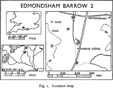
The barrow, the excavation of which is described below, is one of the two situated close to the Cranborne-Wimborne road, some 150 yards north of the Avenue Lodge entrance to St Giles' Park, in the parish of Edmondsham, Dorset.—Nat. Grid. Ref. SU 04611155 and SU 04631160, and map (fig. 1, no. 3).

The attention of the Ministry of Works was drawn early in 1959 to the denudation by ploughing of Barrow 2. Permission to excavate was given by Lord Shaftesbury, the owner, and by Mr Lawes, the tenant farmer. Excavation on behalf of the Ministry of Works was planned and carried out by the writer, with the assistance of two workmen and some volunteers, during July and August 1959.
The Edmondsham barrows are situated at the foot of the long, gentle slope down from St Giles' Crossroads, at the edge of the Park, on a slight rise in the chalk. The land in this area is fairly heavily wooded, and is not typical downland, although the sub-soil is chalk. The junction of the chalk and the clay-with-flints lies only half a mile to the east of the barrow under discussion, at the village of Edmondsham.
Ant. J. Antiquaries Journal
Arch. Archaeologia.
Arch. Ael. Archaeologia Aeliana
Arch. Comb. Archaeologia Cambrensis
Arch. J. Archaeological Journal
BM Guide to the later Prehistoric Antiquities of the British Isles, British Museum 1953.
Bull. Bd. Celt. Studies Bulletin of the Board of Celtic Studies
DNH & FC Dorset Natural History and Field Club
Oxon. Oxoniensia
PPS Proceedings of the Prehistoric Society
PSA Proceedings of the Society of Antiquaries of London
PSAS Proceedings of the Society of Antiquaries of Scotland
T. Dev. Assn. Transactions of the Devonshire Association
VCH Wilts. Victoria County Histories, Wiltshire, vol. 1, part 1, 1957
WAM Wiltshire Archaeological Magazine