


Introduction
The Cerrado biome is one of 36 biodiversity hotspots (Kong et al. Reference Kong, Zhou and Jiao2021); however, more than half of it has been destroyed, and its devastation continues at an accelerating pace (Brito & Silva Reference Brito and Silva2019, Azevedo et al. Reference Azevedo, Rosa, Shimbo, Oliveira, Valdiones, Del Lama and Teixeira2022). This poses a risk to biodiversity conservation of the world’s richest savannah (Silva & Bates Reference Silva and Bates2002) and also to the country’s water security (Santos Reference Santos2017).
In addition, illegal deforestation and burning in the Cerrado correspond to c. 11.4% of Brazil’s annual gross greenhouse gas emissions, with a forest loss rate that is three times larger than in the Amazon (Potenza et al. Reference Potenza, Quintana, Cardoso, Tsai, Cremer and Barcellos e Silva2021). The adoption of efficient command and control (C&C) actions by public authorities lies at the core of the challenges of mitigation and adaptation to climate change.
However, even during 2005–2009 when the federal government made significant efforts to reduce deforestation with the Action Plan for Preventing and Controlling Deforestation in the Legal Amazon (PPCDAm), the effectiveness of sanctions on illegal deforestation was limited; the amount paid by those deforesting in many years represented less than 1% of the total value of the fines applied. A more recent survey of the actions taken by state agencies in the face of automated alerts from the MapBiomas platform (a non-government initiative to map land-use change in South America) indicated that 98% of deforestation in Brazil in 2021 was illegal (Azevedo et al. Reference Azevedo, Rosa, Shimbo, Oliveira, Valdiones, Del Lama and Teixeira2022).
A recent increase in deforestation in the Legal Amazon (a political boundary delimiting Brazil’s states in the Amazon and parts of the Cerrado and Pantanal in Mato Grosso) occurred as a consequence of the intentional dismantling of environmental enforcement capacity by the federal government (Rajão et al. Reference Rajão, Schmitt, Nunes and Soares-Filho2021). Deforestation also occurred in the Cerrado: from 6300 km2 in 2019, it increased each year up to 10 700 km2 in 2022 (Assis et al. Reference Assis, Ferreira, Vinhas, Maurano, Almeida and Carvalho2019).
In this context, the local unit of the Public Prosecutor’s Office in the municipality of Itiquira (Mato Grosso) in July 2018 began to carry out remote inspections in an attempt to identify flagrant instances of illegal deforestation, notify landowners and request field inspection when remote inspection was not sufficient or possible. This Projeto Olhos da Mata (Eyes of the Forest Project) used the free platform Global Forest Watch (GFW) to monitor illegal deforestation together with the administrative inspection agencies, namely the Mato Grosso State Secretary for the Environment (SEMA-MT) and the Brazilian Institute for the Environment and Renewable Natural Resources (IBAMA). Here, we present the results of the near-to-real-time remote monitoring by the Public Prosecutor’s Office in Itiquira during the first 4 years of the Projeto Olhos da Mata to compare forest loss before and after the enforcement and prosecution of the illegal deforestation in that municipality. We make recommendations to extend the project in order to reduce illegal deforestation and validate the importance of the Public Prosecutor’s Office action for controlling illegal deforestation in the Cerrado.
Methods
The main tool used by the Public Prosecutor’s Office in Itiquira to monitor forests is the GFW platform (available at https://www.globalforestwatch.org/); this platform sends and makes available alerts of new deforestation and hotspots in near real time (5–8 days for deforestation and 24–72 h for fires). The area of interest is registered on the platform itself using available geographical boundaries (e.g., political boundaries of municipalities, hydrographic basins). Thus, information is sent by email whenever new alerts become available for the areas of interest.
There are several public platforms available for monitoring deforestation in Brazil (e.g., MapBiomas, TerraBrasilis, etc.), but the GFW data were chosen for ease of use, the platform’s user-friendly interface, it being entirely free of charge and for the alerts that are issued in close to real time (a few days after forest loss), which makes possible early prevention of deforestation. The platform further incorporates a suite of high temporal and spatial resolution orbital images (Landsat, Sentinel-2 and PlanetScope), which facilitates identification of false positives.
Once the alert is received, an employee or volunteer from the Public Prosecutor’s Office can simply extract the coordinates and search for the property where the coordinates were found in the Cadastro Ambiental Rural (Rural Environmental Registry; CAR) database using software such as Google Earth Pro (all the software used in the project was free of charge, avoiding incurring the cost of hiring an employee fully dedicated to the project). The CAR is an environmental control and monitoring tool established by law, in which all rural properties in Brazil are registered. It identifies their areas of protected native vegetation and human-modified areas to integrate environmental with rural property and owner information.
In the Cerrado in Mato Grosso State, 72% of the entire deforestation in 2021 occurred in properties registered in the CAR (Valdiones & Silgueiro Reference Valdiones and Silgueiro2022). Thus, simply relating the geographical coordinates of an alert to the CAR database enabled the location of the environmental crime involved in the vast majority of cases.
Once the property and its owner have been identified, the next step is to seek the owner’s contact details (telephone number, address, etc.) through the Public Security Information System at the Ministry of Justice, to which prosecutors have access. Through this system, it is possible to find details such as the address and telephone number declared by a person to the Brazilian Federal Tax Agency or the National Traffic Department.
Once the owner of the property has been contacted, the prosecutor sends a notification via WhatsApp, email or, when electronic contact is not possible, by post. The notification requires the owner to cease any unauthorized deforestation of native vegetation in that property. This is considered preventative because it is based on alerts that have not been confirmed in the field (subject to the occurrence of false positives) and have the potential to limit the behaviour of the environmental offender, as the owner becomes aware that the government already knows that there is an illegal action underway and that continuing the action may result in more serious sanctions.
Field inspections have been restricted to cases in which notification has not been possible (address not known or property not declared in the CAR) or, where there has been notification, followed by recalcitrance on the part of offenders and continuing deforestation, even after notification. When the Prosecutor has requested a field inspection by the Environmental Police, the result has often been the seizure of machinery and even the arrest of the agents who carried out the illegal deforestation. The Public Prosecutor’s Office Projeto Olhos da Mata aimed to detect forest loss from near-real-time alerts and to serve notice of prosecution to landowners for illegal deforestation.
If the owner stops practising the illicit environmental act, the owner is invited to sign a Conduct Adjustment Commitment (TAC) – an agreement with the Public Prosecutor’s Office aimed at repairing the environmental damage. The agreement provides, for example, for the recovery of the illegally deforested areas and also for monetary compensation for the damage caused, including CO2 emissions.
A partnership was established between the Itiquira Prosecutor’s Office and the regional Environmental Police department. As a result, the latter agency began to benefit from the allocation of resources from the agreements made with the deforesters for the purpose of improving the inspection capacity of the Environmental Police (the agreements often provided for the donation of equipment for inspections and even the funding of training for police officers working in environmental defence).
In cases in which no TAC is signed, a public civil suit is filed, and criminal liability is also assigned if there are sufficient elements available for individualizing the conduct.
To compare the impacts of illegal deforestation in the Itiquira municipality before and after the Public Prosecutor’s Office actions, we used data of administrative acts from SEMA-MT and IBAMA (embargo notices, infraction notifications and deforestation authorizations). An embargo notice is the administrative act that restricts a certain activity, and it is defined in a document (embargo term) that delimits the size of the area and the activities prohibited at the site of the environmental offense. The infraction notice is the document that describes and records, for the purpose of sanctions and punishments, a certain conduct that has been previously defined in law or regulatory decree as an administrative infraction. Deforestation authorizations are administrative acts that allow deforestation in rural properties according to law; however, during the period analysed, there were no authorizations issued for Itiquira municipality.
We also used data from the Brazilian Amazon Rainforest Monitoring Programme by Satellite (PRODES) and the Real-Time Deforestation Detection System (DETER), both developed by the Brazilian Space Research Agency (INPE) to monitor and quantify deforestation in Brazil, to analyse the results of the Public Prosecutor’s Office enforcement. Via DETER, INPE identifies and (on a monthly basis) maps areas in the Cerrado biome that have been deforested since 2018 based on satellite images from Landsat and other satellites (CBERS, Sentinel-2) for visual inspection. Additionally, INPE also quantifies the annual deforestation area using Landsat images with greater resolution than DETER for all biomes from PRODES, which are considered the official data for annual deforestation in Brazil. PRODES data were evaluated from 2012, because that is the year in which the New Forest Code of Brazil (Law 12.651/2012) was introduced, after which we noted an annual increase in deforestation in the Cerrado biome in Mato Gross State. Both deforestation datasets use the methodologies of Almeida et al. (Reference Almeida, Maurano, Valeriano, Camara, Vinhas and Motta2022) and are published and updated constantly on the TerraBrasilis platform (Assis et al. Reference Assis, Ferreira, Vinhas, Maurano, Almeida and Carvalho2019).
Results
Enforcement and prosecution data before the Public Prosecutor’s Office project (2012–2017)
Of the total deforestation registered by PRODES between 2012 and 2017, rural properties in Itiquira with registration in the CAR accounted for 86.7% (3109 ha) of the deforestation, whereas only 358 ha were detected in rural properties not yet registered in the CAR, and 117 ha were in government settlement projects for agrarian reform.
All deforestation detected between 2012 and 2017 was illegal because SEMA-MT had not authorized any deforestation. Despite the illegality, SEMA-MT and IBAMA did not embargo any illegally deforested area during this period and had only issued two infraction notices for illegal deforestation (SEMA-MT embargo, infraction notice and deforestation authorization data up to July 2018 available at http://transparencia.sema.mt.gov.br; IBAMA embargo and infraction notice data up to 16 August 2018 available at http://siscom.ibama.gov.br).
No public civil lawsuits or TAC agreements with respect to illegal deforestation were found for the period 2012–2017. The infractions went unpunished until 2018 as a result of the limited enforcement capacity of SEMA-MT and IBAMA.
Enforcement and prosecution data after the use of GFW by the Public Prosecutor’s Office (2018–2020)
Out of a total of 78 notifications issued between 2018 and 2020, none of the offenders continued the deforestation in the following months. In five cases, deforestation actions were changed to nearby locations (other properties belonging to the same owner). In two cases, unauthorized deforestation was resumed, with the suppression of bushy or herbaceous vegetation and the maintenance of woody vegetation. However, in c. 90% of the cases, there was a suspension of unauthorized activities such as illegal deforestation and burning of cut vegetation residues.
During 2018–2020, no deforestation permits were found in SEMA-MT’s database; thus, all of the deforestation identified was illegal. However, 42 SEMA-MT embargoes and infraction notices issued by SEMA-MT were identified in the municipality of Itiquira in the period 2018–2020, as well as five embargoes and infraction notices for illegal deforestation issued by IBAMA. The total of 47 embargoes and infraction notices represent an increase of 2350% in administrative acts against illegal deforestation over the period compared to the previous year. Of these 47 infraction notices and embargoes, 46 resulted from a request for an investigation by the Public Prosecutor’s Office, as the Itiquira prosecutor detected the deforestation before IBAMA or SEMA-MT had and ordered that administrative action be taken.
In this period, there were 13 criminal complaints filed, seven proposals for criminal settlements, three agreements for non-prosecution and another 10 investigations were ongoing. Regarding civil law for environmental damage reparation, 11 public civil suits were proposed, nine agreements were signed and another five civil inquiries were ongoing.
Before the Public Prosecutor’s Office issued the notifications, the number of deforestation alerts from the DETER for the Cerrado biome was tending to increase in the municipality of Itiquira; this trend was reversed after the notifications for deforestation began to be issued in March 2019 (before this date, the Projeto Olhos da Mata focused on alerts for fires), and the time series of alerts showed a sharp reduction (Fig. 1). In addition, given the growth in deforestation in the state of Mato Grosso and the Cerrado biome since 2018, the municipality of Itiquira showed the smallest deforestation rate increase in the historical series of PRODES (Fig. 2).
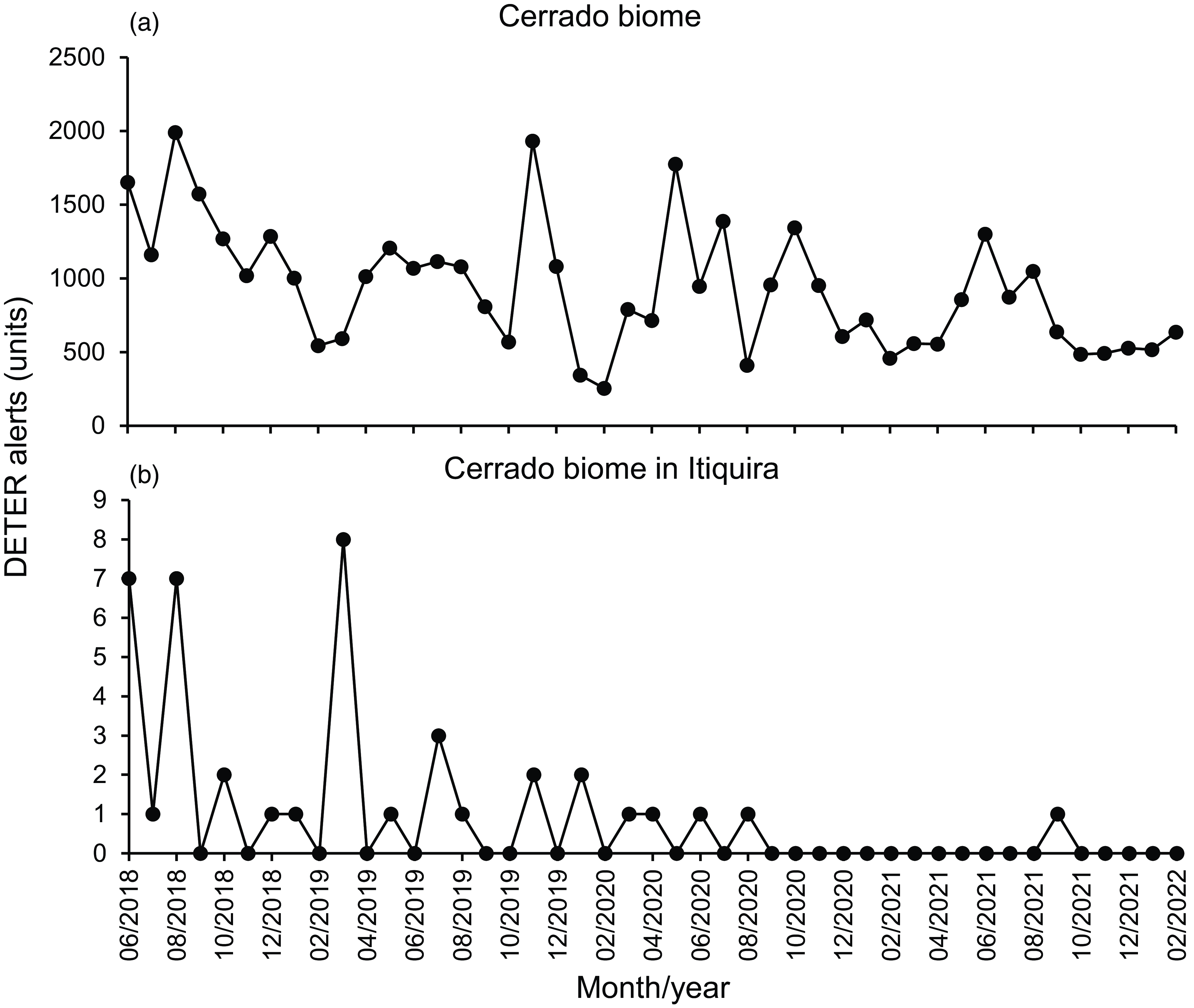
Figure 1. Comparison between the number of Real-Time Deforestation Detection System (DETER) alerts in (a) the Cerrado biome as a whole and (b) in Cerrado in Itiquira municipality specifically before and after the start of notifications in 2019 by the Projeto Olhos da Mata. Source: TerraBrasilis/DETER/Brazilian Space Research Agency (INPE).
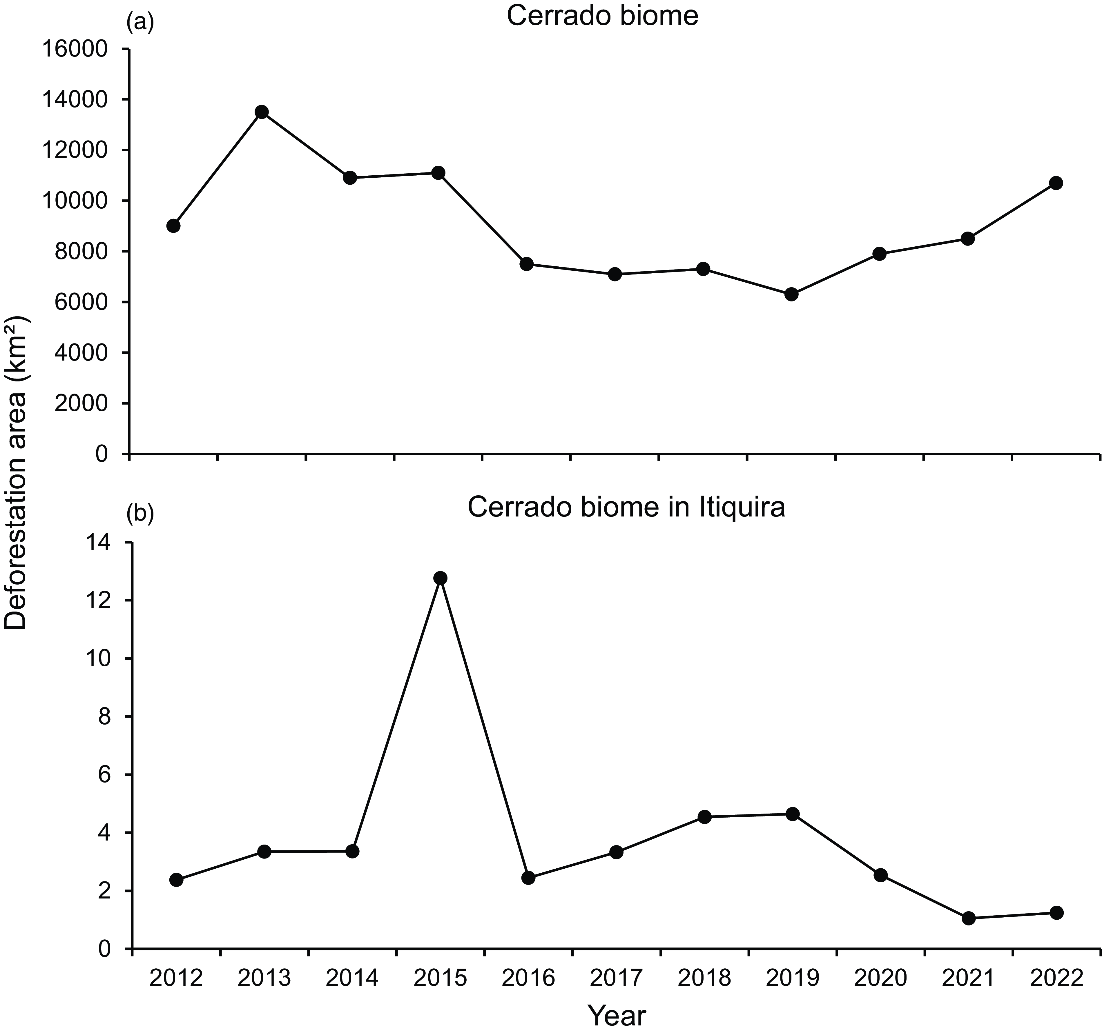
Figure 2. Comparison between the increment of deforestation area in (a) the Cerrado biome as a whole and (b) in Cerrado in Itiquira municipality specifically before and after the start of notifications by the Projeto Olhos da Mata. Source: TerraBrasilis/Brazilian Amazon Rainforest Monitoring Programme by Satellite (PRODES)/Brazilian Space Research Agency (INPE).
Discussion
When the environmental inspection agency fails to take enforcement actions, this not only reduces the probability of applying administrative sanctions (fines and embargoes) but also eliminates the possibility of filing public civil suits and criminal lawsuits. In the Projeto Olhos da Mata and in other recent Public Prosecutor’s Office projects, this merely reactive paradigm has been overcome with the use of remote sensing data employed directly by the Public Prosecutor’s Office technical teams.
In the Brazilian legal system, it is possible to combine criminal liability (the imposition of a penalty for the commission of a crime) and civil liability (the repair of environmental damage) in a single criminal suit. Thus, a public civil suit is generally reserved for the most complex cases, or those in which there are not enough elements to initiate criminal proceedings. In addition, prosecutors usually concentrate several infraction reports that occurred on the same or neighbouring properties belonging to the same owner into a single public civil suit or criminal action.
As can be seen, the participation of the Public Prosecutor’s Office in monitoring illegal deforestation resulted in a significant increase in the number of actions for administrative, criminal and civil liability for the environmental damage caused, whilst at the same time there has been a reduction in deforestation rates. In 2019, this incipient experience of remote inspection in Itiquira was shared with SEMA-MT, which also adopted a similar remote surveillance procedure for monitoring all biomes in Mato Grosso State (Cerrado, Amazonia and Pantanal), albeit one using the private SCCON geospatial platform instead of GFW. It should be noted that the actions of the Public Prosecutor’s Office did not substitute for the actions of SEMA-MT and IBAMA. Instead, they provoked the action of those agencies in cases in which the environmental inspection would not have occurred (as indicated by the inspection history).
We hypothesized that initiating inspection actions at the outset of unauthorized land-use change activities could lead to reduced environmental damage, preventing the deforestation of hundreds or thousands of hectares that might take several months to transpire. Additionally, we observed that executing agreements (conduct adjustment agreements) aimed at the civil reparation of environmental damage is more feasible for small than large deforested areas.
The practice of electronic notifications to landowners as a result of remote sensing also enabled a screening process for field operations according to whether or not the deforesting owners cooperated with the notification from the prosecutor. In the first case, once the illicit undertaking had ceased, the inspection might be restricted to remote action; however, for persistent violators who did not cooperate with the inspection, the C&C instruments can be more rigorous in terms of halting infractions by owners. In this way, the C&C instruments, which in any case could only be used for a small number of violations, can be streamlined and targeted to cases in which remote enforcement has not proven effective.
The Public Prosecutor’s Office as well as the environmental enforcement agencies have their limitations, especially regarding the number of personnel and time limitations due to the prosecutors’ workloads. As for limitations amongst technicians, it should be noted that the Projeto Olhos da Mata required only elementary technical knowledge given the simplicity of the procedure and ease of use of the GFW platform.
In the municipalities with the highest deforestation rates, the Judiciary and the Public Prosecutor’s Office face serious structural problems, such as a shortage of civil servants and an absence of interns, as well as the accumulation of the procedural backlog. There are additionally various social problems that require emergency action by prosecutors who probably have other duties besides defending the environment, such as the defence of the rights of children and the elderly, criminal prosecutions and electoral matters.
Creating a group of prosecutors specialized in environmental matters operating throughout the state of Mato Grosso and its biomes (Amazonia, Cerrado and Pantanal) to monitor and combat illegal deforestation could help alleviate these structural difficulties.
If the initial positive results of environmental enforcement are to be sustained, interactions and learning between landowners and environmental authorities will be needed – a process that may take several years and require the adaptation or creation of new C&C instruments (Börner et al. Reference Börner, Wunder, Wertz-Kanounnikoff, Hyman and Nascimento2014). Degradation can continue in ways that are not easily identifiable through automated alerts, such as the economic use of embargoed areas (e.g., agriculture, livestock, etc.), drainage of wetlands, deforestation of part of the vegetation that is more difficult to detect via remote sensing (such as suppression of understory or shrub formations) and planting of exotic grasses in natural grassland formations.
Given the low cost of implementation and the widespread reach of the Public Prosecutor’s Office in the municipalities, it is possible to sustain the potential for replication of an institutional arrangement such as the one carried out by the Projeto Olhos da Mata in other Brazilian municipalities, especially those located in the Cerrado (Tollefson Reference Tollefson2018), where deforestation normally occurs through the implementation of large agricultural projects, making it easier to identify landowners.
One lesson that can be drawn from the dismantling of public policies and environmental protection agencies promoted by the previous government in Brazil (Rajão et al. Reference Rajão, Schmitt, Nunes and Soares-Filho2021) is that decentralizing monitoring and enforcement actions can make environmental protection more resilient during periods when the federal or state government lacks the will to fulfil its constitutional duty to protect the environment.
The participation of the Public Prosecutor’s Office – an institution endowed with administrative, budgetary and financial autonomy and composed of career public servants who have the same constitutional powers as judges in the detection and independent monitoring of deforestation – can contribute to mitigating the consequences of political interference and shifting interests in the Brazilian environmental protection system. It can also reduce the probability of impunity, as criminal prosecution and civil reparation for damage are not confined to the exclusive action of Brazilian environmental control agencies.
Furthermore, because it has the constitutional duty to promote actions for repairing environmental damages, the Public Prosecutor’s Office can fulfil this mission in a less costly and more effective preventative manner, with an inhibitory extrajudicial act that costs much less than going to court after major environmental damage has already occurred. It will always be more economical and beneficial to the environment to prevent major deforestation instead of trying to repair environmental damage that in many respects is irreparable.
Acknowledgements
None.
Financial support
This research received no specific grant from any funding agency in the public, commercial or not-for-profit sectors.
Competing interests
CACG and JGR are civil servants of the Public Prosecutor’s Office of the State of Mato Grosso and were responsible for the conception and execution of the project described in this article.
Ethical standards
None.


