


Clay minerals play a major role in the functioning of soils and in defining surface and subsurface processes (Dixon, Reference Dixon1991; Saffer et al., Reference Saffer, Frye, Marone and Mair2001; Hartemink & Bockheim, Reference Hartemink and Bockheim2013; Kasanin-Grubin, Reference Kasanin-Grubin2013). Soils containing smectite, for example, are more prone to water erosion than soils containing kaolinite (Wakindiki & Ben-Hur, Reference Wakindiki and Ben-Hur2002). The study of clay minerals in weathering environments during soil formation is a complicated subject due to the many parameters involved in the processes (Velde & Meunier, Reference Velde and Meunier2008; Ferrell et al., Reference Ferrell, Aparício, Forsman, Fiore, Cuadros and Huertas2013; Munroe et al., Reference Munroe, Ryan and Proctor2021). In semi-arid climates, characterized by incomplete hydrolysis products of primary minerals (Curtis, Reference Curtis1990), different factors control soil phyllosilicate mineralogy, including erosion processes, pH and major oxide contents (in particular SiO2, Al2O3, Fe2O3, MgO and K2O), land use, topography, type and amount of organic matter entering the soil and soil structure and texture (Chorom et al., Reference Chorom, Rengasamy and Murray1994; Haynes & Naidu, Reference Haynes and Naidu1998; Ben-Hur & Wakindiki, Reference Ben-Hur and Wakindiki2004; Kasanin-Grubin, Reference Kasanin-Grubin2013; Barré et al., Reference Barré, Fernandez-Ugalde, Virto, Velde and Chenu2014). The distribution of clay minerals in the horizons of pedological profiles constitutes a reliable tool for determining the conditions of their formation (Singer, Reference Singer1980; Eberl et al., Reference Eberl, Farmer and Barrer1984; Ducloux et al., Reference Ducloux, Guero and Fallavier1998).
Recent work on the genesis of clay minerals in the pedological formations of semi-arid regions has demonstrated significant progress in several regions of the world such as Morocco (Daoudi, Reference Daoudi1996; Daoudi et al., Reference Daoudi, Ouajhain, Rocha, Rhouta, Fagel and Chafiki2010; Omdi et al., Reference Omdi, Daoudi and Fagel2018; Gourfi et al., Reference Gourfi, Daoudi, Rhoujjati, Benkaddour and Fagel2020), northern Cameroon (Nguetnkam et al., Reference Nguetnkam, Kamga, Villiéras, Ekodeck and Yvon2008), southern Iran (Khormali & Abtahi, Reference Khormali and Abtahi2003), and California (McFadden et al., Reference McFadden, Wells and Dohrenwend1986). The conclusions of the abovementioned works improve our understanding of the processes linked to the mineralogy of clays in semi-arid zones. However, in the Sahel in Africa, due to the accelerated degradation of ecosystems induced by strong climatic variations and increasing human activities, research projects are largely oriented in favour of the sustainable management of natural resources and ecosystems (Lebel et al., Reference Lebel, Cappelaere, Galle, Hanan, Kergoat and Levis2009; Elagib et al., Reference Elagib2021), and few studies have focused on the genesis and evolution of clay minerals in this area. In south-western Niger, studies spanning several decades have focused on the clay assemblages of Quaternary formations (Gavaud, Reference Gavaud1968; Bui & Wilding, Reference Bui and Wilding1988; Guero, Reference Guero1989, Reference Guero2000; Ducloux et al., Reference Ducloux, Guero, Fallavier and Valet1994, Reference Ducloux, Guero and Fallavier1998, Reference Ducloux, Guero, Sardini and Decarreau2002). The hypotheses put forward concerning the genesis of clay minerals in soils are sometimes controversial and are still under discussion. This study is part of this perspective, and its main objective is to determine the origin and distribution of clay minerals in the pedological horizons of the Kori Ouallam watershed. This basin is a vast territory in south-western Niger, chosen because of the diversity of the pedological facies present, which evolved in a contrasting semi-arid climatic context. The specific objectives are: (1) to identify the different clay minerals formed at the scale of the Kori Ouallam watershed; (2) to determine the distribution pattern of clay minerals at the scale of the pedological horizons; and (3) to critically examine the origins of the clay minerals.
Materials and methods
Study area
The study was conducted in the Kori Ouallam watershed, a semi-arid area in the extreme south-western part of Niger located between 14°4'27"N and 2°5'99"E (Fig. 1). For several decades, this vast area (10 740 km2) has been subjected to degradation of its ecosystems induced both by the hostility of the climate and the growing anthropogenic pressure on natural resources (Mamadou et al., Reference Mamadou, Gautier, Descroix, Noma, Bouzou Moussa and Faran Maiga2015; Mamoudou, Reference Mamoudou2018). The climate is of Sahelian type, characterized by a dry season from October to May and a wet winter season from June to September. The average annual rainfall ranges from ~376 mm in the north to ~516 mm in the south (DMN, 2015). This irregular but highly intensive rainfall pattern (Panagos et al., Reference Panagos, Borrelli, Meusburger, Yu, Klik, Lim and Yang2017) falls on encrusted soils with low retention capacity (Malam Issa et al., Reference Malam Issa, Valentin, Rajot, Cerdan, Desprats and Bouchet2011; Malam-Abdou et al., Reference Malam-Abdou, Vandervaere, Bouzou-Moussa, Descroix, Mamadou and Faran-Maiga2016), thereby drastically accelerating water erosion, generating an annual average potential soil loss of 1.54 t ha–1 at the scale of the Kori Ouallam watershed (Noma Adamou et al., Reference Noma Adamou, Gourfi, Abdourhamane Touré and Daoudi2022). Daily maximum temperatures reach 45°C in April and May, and minima of 12°C are observed between December and January. The average monthly potential evapotranspiration is ~170 mm (DMN, 2015). The wind has a seasonal regime typical of Sahelian environments; it is characterized by two wind types: the Harmattan, a dry wind blowing from November to March in a north-east to south-west direction; and the monsoon, a wet wind blowing from south-west to north-east between May and September. The average daily wind speed usually exceeds 5 m s–1 (Abdourhamane Touré et al., Reference Abdourhamane Touré, Rajot, Garba, Marticorena, Petit and Sebag2011).

Figure 1. Location and geological map of the Kori Ouallam watershed.
Geologically, the Kori Ouallam watershed is dominated by Quaternary formations (61%), consisting mainly of aeolian sandy deposits and alluvium located in the valleys at a low altitude of ~215 m (Fig. 1). The sandstone plateaus and slopes (38% of the Continental Terminal, CT3) of Middle Eocene to Quaternary age occupy the relatively high plateaus and slopes with an altitude of 374 m (Pougnet & Greigert, Reference Pougnet and Greigert1965; Lang et al., Reference Lang, Kogbe, Alidou, Alzouma, Bellion and Dubois1990). The basement of Birimian age is weakly represented and appears in the extreme north-west, occupying only 1% of the total surface area of the watershed. The woody vegetation is sparse, consisting mainly of Guiera senegalensis, Combretum micranthum and Combretum glutinosum, which grow on sandy and nutrient-poor soils (Ambouta & Dan Lamso, Reference Ambouta and Dan Lamso1996; Boubacar, Reference Boubacar2016).
Sampling protocol
The sampling protocol adopted for this study is based on the pedological map of south-western Niger (Fig. 2), which was drawn up on the basis of the physicochemical and geomorphological properties of the soils, with a classic nomenclature organized into soil subsets, divided into facies, families and series (Gavaud & Boulet, Reference Gavaud and Boulet1967). The diversity and extent of the pedological formations, combined with the recurrent security threats in the far north of the Kori Ouallam watershed, meant that the investigation was focused on the major subsets of the soil types representing the most dominant facies (Fig. 2). A total of 49 samples, divided into two groups, were obtained from the entire watershed. The first group consisted of 28 soil samples from the upper soil horizons between 0 and 10 cm in depth, and the second group consisted of 21 profile samples from the different horizons from six 1 m-thick pedological profiles (Figs 2 & 3; Ducloux et al., Reference Ducloux, Guero, Sardini and Decarreau2002). The sampled pedological units are characterized by geomorphological, geological and environmental diversity (Fig. 4). The Munsell colour code was used to identify the colour of the horizons of the various profiles.

Figure 2. Pedological map of the study area and locations of the soil and profile samples (modified from Gavaud & Boulet, Reference Gavaud and Boulet1967).

Figure 3. Pedological profiles: (a) profile 1, (b) profile 2, (c) profile 3, (d) profile 4, (e) profile 5 and (f) profile 6.
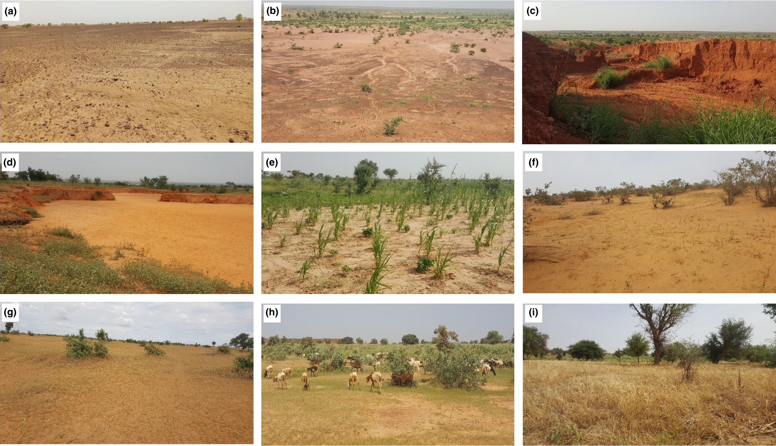
Figure 4. Sampled landscapes: (a) lateritic soils of low-slope plateaus of the Continental Terminal, (b) lateritic soils of the steep versants of the Continental Terminal, (c) Continental Terminal soils from bank erosion, (d) sandy deposits of the valleys from rainwater drainage, (e) low-slope agricultural Quaternary lands, (f) encrusted soils of the Quaternary glacis, (g) fallow lands, (h) pastoral lands and (i) set-aside lands.
Methods of analysis
The samples were subjected to a series of laboratory analyses for characterization of their mineralogical, physicochemical and microscopic properties. These included X-ray diffraction (XRD), particle-size distribution, soil organic matter and calcium carbonate content and X-ray fluorescence (XRF) spectrometry analyses and microscopic observations using a binocular magnifying lens and a scanning electron microscope (SEM) equipped with an energy-dispersive X-ray spectroscopy (EDX) system.
The mineralogical composition was determined by XRD using a Bruker D8-Eco Advance diffractometer with monochromatic Cu-Kα radiation (scanning step size: 0.02°; time step: 0.6 s) operated at 40 kV and 25 mA from 2 to 70°2Q on powdered bulk sediment and on the <2 μm fraction (Argiles, Géochimie et Environnements Sédimentaires (AGEs), Department of Geology, University of Liège). The bulk mineralogy was identified on samples gently crushed and passed through a 250 μm dry sieve. The <2 μm clay fraction samples were prepared according to the standard procedure – namely, with separation by settling in a water column and then mounting as oriented aggregates on glass slides (Moore & Reynolds, Reference Moore and Reynolds1997). For each sample, three XRD traces were recorded: air dried (N), ethylene glycol solvated for 24 h (EG) and heated at 500°C for 4 h (H). The background noise of the XRD traces was removed and the line position, intensity peak and integrated area were calculated using HighScore Plus software. Semi-quantitative estimates of the minerals present were achieved by measuring the intensity of the diagnostic peaks of the various minerals identified by XRD and application of correction factors specific to each mineral for the bulk samples and the EG series from the clay fractions following the methodology described in Table 1.
Table 1. Semi-quantitative method for the estimation of sample mineralogical composition.

The particle-size analyses were carried out using a HORIBA LA-300 laser diffraction analyser to determine the clay, silt and sand particles with a monochromatic laser beam (Baosupee et al., Reference Baosupee, Massey, Nazhad and Hubbe2014). The total organic matter content was determined from loss on ignition (LOI) at 550°C for 4 h (Heiri et al., Reference Heiri, Lotter and Lemcke2001). Calcium carbonate content was determined with the calcimeter method that uses 10% HCl to measure the volume of carbon dioxide (CO2) released (Hulseman, Reference Hulseman1966; Muller & Gatsner, Reference Muller and Gatsner1971). The abovementioned analyses were carried out at the Laboratory of Georesources, Geoenvironment and Civil Engineering (L3G), Cadi Ayyad University, Marrakech.
SEM observations were also carried out using a Tescan Vega-3 SEM equipped with a high-performance EDX system at the Analysis and Characterisation Centre (CAC), Cadi Ayyad University, Marrakech.
Results
Soil samples
Particle-size distribution and organic matter and calcium carbonate content
The soils of the Kori Ouallam watershed are characterized by low organic matter content (<1%; Table 2). No trace of calcium carbonate (CaCO3) was detected in any sample. Laser granulometry allowed the identification of seven classes of soil textures, marked by a predominance of sandy clay loam and sandy loam textures (Fig. 5 & Table 2).
Table 2. Results regarding the particle-size distribution and organic matter content of the soils.
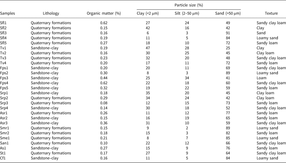

Figure 5. Texture classes of the soil samples.
Mineralogical composition
The semi-quantitative analysis of the soil samples by XRD shows that, at the scale of the whole watershed and independently of the pedological facies, the mineralogical composition of the bulk samples is constant. The samples are dominated by quartz (60–96%), associated with total clay (2–29%), K-feldspar (0–5%), plagioclase (0–4%) and hematite (0–3%; Figs 6a & 7a). The highest proportions of total clay were observed on lateritic soils (Fps3, Fps4, Fps5) formed on the sandstones. This lithology is especially observed on the plateaus and versants of the Continental Terminal (Fig. 2).

Figure 6. XRD traces of (a) bulk samples and (b) clay fractions (N, EG, 500°C).

Figure 7. Mineralogical composition of soils: (a) bulk mineralogy and (b) clay mineralogy.
The mineralogical composition of the clay fractions does not show a variable spatial trend. Kaolinite is the most abundant clay mineral (82–99%), associated with illite (1–18%, average 4%), whilst chlorite is present in trace amounts (Figs 6b & 7b).
Chemical composition
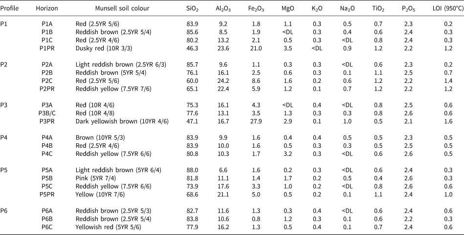
The chemical composition of the soil samples consists mainly of SiO2 (70–89%), Al2O3 (5–20%), Fe2O3 (1–4%) and P2O5 (~2%). MgO, K2O, MnO, Na2O and TiO2 are present in low concentrations, sometimes below the detection limit of the analytical method (Table 3). CaO is below the detection limit for all of the samples. Al2O3 and Fe2O3 are more abundant in samples Fps3, Fps4 and Fps5 (13–20 and 3–4 wt.%, respectively), associated with the lowest contents of SiO2 (70–78 wt.%). The abundances of SiO2, Al2O3 and Fe2O3 are in accord with the mineralogical composition dominated by quartz, K-feldspar, clay minerals and hematite. Values below the detection limit for CaO can be explained by the absence of carbonate minerals and the low abundance of plagioclase.
Table 3. Major chemical composition of oxides (wt.%) in the soil samples.

<DL= below detection limit.
Profile samples
Physicochemical and mineralogical characteristics
The textures of the samples from the pedological profiles range from sandy loam to sandy clay loam in horizons A and B (Fig. 8a,b) and from clay loam to clay in horizon C and the parent rock (Fig. 8c,d). The samples are characterized by a low organic matter content (<1%) and are free of calcium carbonate (Fig. 9). The particle-size distribution shows an increase in clay and silt particles with depth at the expense of sand particles (Fig. 9).

Figure 8. Texture classes of profile horizons: (a) horizon A, (b) horizon B, (c) horizon C and (d) parent rock.

Figure 9. Physicochemical and mineralogical properties of the soil profile samples: profile 1 (P1), profile 2 (P2), profile 3 (P3), profile 4 (P4), profile 5 (P5) and profile 6 (P6).
Quartz is the most abundant phase in the various horizons (23–95%), associated with total clay (3–45%), hematite (0–16%), goethite (0–15%), K-feldspar (0–14%) and traces of anatase (<1%). In some samples, the presence of minerals with a high iron content (hematite, goethite) is also supported by the geochemical analyses, showing high proportions of Fe2O3 ranging from 5% to 28% (Table 4). These minerals were identified mainly in the parent rock (P1, P2 and P3; Fig. 9). The total clay content increases at depth, from 3% in the subsurface to 45% in horizon C or the parent rock. Abundant K-feldspar (10–14%) is detected exclusively in the parent rock (profiles P1, P2 and P4), decreasing progressively or abruptly upwards.
Table 4. Major chemical composition of oxides (wt.%) in the profile samples.
<DL= below detection limit.
The mineralogical composition of the clay fractions is similar to the soil composition, marked by the dominance of kaolinite (64–98%). Illite is present in variable concentrations (0–34%), with a maximum being recorded in the upper horizons of profiles P1, P2 and P4. Chlorite was detected in trace amounts in all samples (<1%).
Microscopic analysis
The SEM analysis was carried out on samples collected from the various soil horizons. The minerals are difficult to identify from their shape (Fig. 10a). EDX microanalysis (Fig. 10b) allowed identification of kaolinite (0.7 < Si/Al < 2.2). The particles of kaolinite are characterized by an average Fe2O3 content estimated at 2.41% (Fig. 10b), which is typical of tropical soils (Herbillon et al., Reference Herbillon, Mestdagh, Vielvoye and Derouane1976).

Figure 10. (a) SEM images and (b) EDX spectra of kaolinite crystals.
Discussion
Grain-size distribution
The grain-size distribution shows a textural differentiation between the different horizons of the same profile that is marked by a predominance of sandy fractions in the surface horizons (Fig. 9). This distribution pattern of granulometric fractions is consistent with previous work carried out in south-western Niger in the villages of Sona and Tillakaina, where 11 out of 15 profiles showed a similar trend (Ducloux et al., Reference Ducloux, Guero, Sardini and Decarreau2002). In the Sahel, this textural differentiation is attributable, on the one hand, to the intense mechanical material transfer processes induced by runoff (Descroix et al., Reference Descroix, Mahé, Lebel, Favreau, Galle and Gautier2009; Mamadou et al., Reference Mamadou, Gautier, Descroix, Noma, Bouzou Moussa and Faran Maiga2015) and, on the other hand, to active aeolian processes acting on a surface with low roughness (Pierre et al., Reference Pierre, Bergametti, Marticorena, Abdourhamane Touré, Rajot and Kergoat2014; Abdourhamane Touré et al., Reference Touré A., Tidjani, Rajot, Marticorena, Bergametti and Bouet2019). In the Sahelian climatic context, Guero (Reference Guero2000) and Ducloux et al. (Reference Ducloux, Guero and Fallavier1998, Reference Ducloux, Guero, Fallavier and Valet2002) highlighted another process underlying the origins of the particle-size distribution at the scale of the pedological profiles: the phenomenon of ‘xerolysis’, which is a mechanism resulting from the alteration and/or dissolution of the clay particles at the soil surface within a relatively hot climate.
Origin and distribution of non-clay minerals
Soils from the upper horizons of the pedological profiles have high organic matter contents due to the accumulation of organic components and plant debris. In contrast, the soils prospected in the Kori Ouallam watershed present insignificant organic matter contents (~1%; Fig. 9). Furthermore, the organic matter content of soils is not related to the mineralogical composition of clays. Similar results have been recorded on soils sampled across south-western Niger (Fofana et al., Reference Fofana, Wopereis, Bationo, Breman and Mando2008; Obame et al., Reference Obame, Copard, Sebag, Abdourhamane Touré, Boussafir and Bichet2014). This organic matter deficit in soils is specific to Sahelian semi-arid environments (FAO, 2014; Suzuki et al., Reference Suzuki, Matsunaga, Hayashi, Matsumoto, Tabo, Tobita and Okada2014, Reference Suzuki, Matsunaga, Hayashi, Matsumoto, Tobita, Bationo and Okada2016).
The samples analysed are free of calcium carbonate (CaCO3), in accordance with the low CaO concentrations (below the detection limit) obtained by XRF fluorescence (Tables 3 & 4) and the notable absence of carbonate minerals such as calcite, aragonite and dolomite in the mineralogical composition (Figs 6, 7 & 9). This deficit in carbonate minerals has also been observed in the Middle Niger Valley (Guero, Reference Guero1989) and is largely attributed to an absence of calcareous sources in the parent materials.
Quartz is the most abundant phase in all of the analysed samples. Its content varies from 60% to 96% in surface samples and from 23% to 95% through the profiles. Observation under the binocular lens shows that the quartz grains of the samples from all soil horizons are angular, suggesting that the quartz grains in the soils were most probably inherited from the underlying parent rock rather than from aeolian supplies.
The decreasing iron oxide contents (hematite, goethite) upwards from the deep horizons to the surface horizons has also been observed in the Niger River valley (Guero, Reference Guero1989). This trend of iron enrichment in lateritic processes resulting from alteration of the parent rock is characteristic of intertropical areas such as the Kori Ouallam watershed (Negrão & da Costa, Reference Negrão and da Costa2021).
Origin and distribution of clay minerals
The processes of clay mineral genesis and evolution in soils of semi-arid areas have generated a wide variety of sometimes controversial discussion (Khormali & Abtahi, Reference Khormali and Abtahi2003; Wang et al., Reference Wang, Hong, Li, Yin, Xie and Liang2013; Zhang & Guo, Reference Zhang and Guo2014; Omdi et al., Reference Omdi, Daoudi and Fagel2018; Gourfi et al., Reference Gourfi, Daoudi, Rhoujjati, Benkaddour and Fagel2020). In this section, we will critically examine the different processes that may be at the origin of the formation of the clay minerals identified in the various pedological horizons of the Kori Ouallam watershed.
Kaolinite
The clay minerals identified are dominated by kaolinite in all horizons, regardless of the diversity of pedological facies or topography. The predominance of kaolinite in the pedological formations of south-western Niger has been well documented in several previous works (Bui & Wilding, Reference Bui and Wilding1988; Ducloux et al., Reference Ducloux, Guero, Fallavier and Valet1994, Reference Ducloux, Guero and Fallavier1998, Reference Ducloux, Guero, Sardini and Decarreau2002; Guero, Reference Guero2000). Kaolinite represents the main clay mineral in tropical Sahelian soils (Lang et al., Reference Lang, Kogbe, Alidou, Alzouma, Bellion and Dubois1990; Driessen et al., Reference Driessen, Deckers, Spaargaren and Nachtergaele2001; Traoré et al., Reference Traoré, Blanchart, Jernot and Gomina2007; Journet et al., Reference Journet, Balkanski and Harrison2014), which might partly explain the low reactivity and productivity of these soils (Duchauffour, Reference Duchauffour1982; Saffer et al., Reference Saffer, Frye, Marone and Mair2001). In all six soil profiles surveyed in the Kori Ouallam watershed, kaolinite abundance remained constant with depth (Fig. 9), which might be largely due to its presence in the parent rocks, as observed in similar semi-arid environments, notably in south-western Niger (Guero, Reference Guero1989; Ducloux et al., Reference Ducloux, Guero, Sardini and Decarreau2002), in central-western Morocco (Omdi et al., Reference Omdi, Daoudi and Fagel2018; Gourfi et al., Reference Gourfi, Daoudi, Rhoujjati, Benkaddour and Fagel2020) and in southern Iran (Khormali & Abtahi, Reference Khormali and Abtahi2003). The parent rocks studied are mainly composed of alluvial Quaternary formations (61%; Fig. 1) rich in kaolinite (Fig. 9). Those formations would constitute a very probable source of the kaolinite identified in the pedological profiles. The observed trend in kaolinite content suggests that the soil materials as a whole have not undergone significant changes. These materials seem to have evolved under a similar climate to the present one (Mohr et al., Reference Mohr, Van Baren and van Schuylenborgh1972; Singer, Reference Singer1980), whose sedimentary environment appears to be relatively constant (Bauluz et al., Reference Bauluz, Yuste, Mayayo and Canudo2014). The irregular morphology of the kaolinites observed by SEM in all of the samples (Fig. 10a) indicates that these may be of detrital origin, most often resulting from remobilization of parent materials, similar to the kaolinite in the sedimentary deposits of the Oliete Basin (north-east Spain; Bauluz et al., Reference Bauluz, Mayayo, Yuste and González López2008). These authors observed that kaolinites of detrital origin are characterized by a xenomorphic form that is difficult to recognize and is poorly crystallized, whereas diagenetic kaolinites are idiomorphic, with good crystallinity, and are easily recognizable, thus highlighting their authigenic origins, with a clear variation in content depending on depth and burial conditions (Arostegui et al., Reference Arostegui, Irabien, Nieto, Sangüesa and Zuluaga2001; Daoudi et al., Reference Daoudi, Ouajhain, Rocha, Rhouta, Fagel and Chafiki2010; Bauluz et al., Reference Bauluz, Yuste, Mayayo and Canudo2014). Extreme chemical alteration processes such as monosialitization linked to morphoclimatic conditions may also lead to the formation of kaolinite (Nguetnkam et al., Reference Nguetnkam, Kamga, Villiéras, Ekodeck and Yvon2008). However, in the Kori Ouallam watershed (Sahelian context specific to south-western Niger), alternating hot and humid climatic conditions associated with a low relief topography slow down the processes of monosialitization. These conditions instead favour bisialitization alteration processes that yield 2:1 clay minerals (smectite or illite). The formation of kaolinite by monosialitization requires, in addition to a suitable climate, good drainage conditions controlled by a steeply sloping topography (Chamley, Reference Chamley1989; Righi, Reference Righi1999), which is not the case for the present study. The combined analysis of the various indices suggests that in the studied soils of the Kori Ouallam watershed the kaolinite is principally inherited from the parent materials.
Illite
The proportions of illite remain low in the various types of studied soils (Fig. 7b). However, at the scale of the pedological profiles (Fig. 9), two distribution patterns are observed. The first reflects a low and stable trend all along the profiles (profiles P3, P5 and P6), and the second shows an increase in illite contents upwards (profiles P1, P2 and P4; Fig. 9). An ascending evolution of illite proportions has also been observed in some soil profiles in central-western Benin (Junge & Skowronek, Reference Junge and Skowronek2007). Guero (Reference Guero1989; south-western Niger) observed a third pattern of illite content evolution in one out of six profiles, marked by relatively low proportions of illite (~5 wt.%) in the surface horizons that progressively increase at depth (up to 15 wt.%). It appears that the distribution of illite in the Sahelian pedological formations is more complex, implying that various processes probably led to the formation of illite. In the following paragraphs, we will present and discuss the main hypotheses to determine the mechanism likely to be responsible for illite enrichment in the upper horizons of the profiles studied.
Terrigenous aeolian dust might be a source of illite at the surface horizons of south-western Niger soils (McFadden et al., Reference McFadden, Wells and Dohrenwend1986; Møberg et al., Reference Møberg, Esu and Malgwi1991; Journet et al., Reference Journet, Balkanski and Harrison2014). The Sahelian region is one of the main sources of dust emission in the world (Prospero & Nees, Reference Prospero and Nees1986; Coudé-Gaussen, Reference Coudé-Gaussen1991; Prospero et al., Reference Prospero, Ginoux, Torres, Nicholson and Gill2002; Bergametti et al., Reference Bergametti, Marticorena, Rajot, Chatenet, Féron and Gaimoz2017; Muhs et al., Reference Muhs, Meco, Budahn, Skipp, Simmons and Baddock2021) through a seasonal east–west transport by the Harmattan wind from Africa to the Atlantic Ocean (McTainsh & Walker, Reference McTainsh and Walker1982). However, the two observed patterns reject a common aeolian supply. Indeed, in the studied region, the wind affects large geographical areas due to its low relief and sparse vegetation.
Differential transport processes by water would be responsible for the enrichment of surface horizons in illite; kaolinite would be more easily transported, which would lead to an increase in the illite proportions of surface samples (Shi et al., Reference Shi, Liu, Fang, Qiao, Khokiattiwong and Kornkanitnan2015; Omdi et al., Reference Omdi, Daoudi and Fagel2018). This hypothesis would also be unlikely to explain this mineralogical differentiation. Indeed, the processes of differential sedimentation mechanisms between illite and smectite are better understood due to the small size and flaky appearance of smectite particles (Gibbs, Reference Gibbs1977; Omdi et al., Reference Omdi, Daoudi and Fagel2018). Moreover, the profiles that are impacted by this differentiation and that should be located in regions exposed to hydrodynamic processes are instead located on flat landforms, which are areas that are less exposed to water action and runoff.
As an alternative hypothesis, illite may result from incomplete hydrolysis processes by bisialitization and transformations of primary minerals from parent rocks (Singer, Reference Singer1984; Jaboyedoff, Reference Jaboyedoff2001; Velde & Meunier, Reference Velde and Meunier2008). The geomorphological and climatic characteristics of south-western Niger are favourable to the partial hydrolysis responsible for the formation of illite. It appears that illite forms by alteration of K-rich primary minerals observed in the parent rock of profiles P1, P2 and P4 (10–14% K-feldspar; Fig. 9). However, in the profiles characterized by very low illite contents (profiles P3, P5 and P6), the K-feldspar peaks were not identified on the XRD traces of the parent rock (Fig. 9). In studying the genesis of pedological clays, Pédro (Reference Pédro1984) observed that bisialitization is one of the major processes underlying the origin of the formation of type 2:1 clays, mainly illite. Paquet (Reference Paquet1970) analysed the geochemical evolution of clay minerals in Mediterranean and tropical climates and concluded that in tropical zones with contrasting seasons, similar to south-western Niger, chemical weathering processes are more intense in those soils with a direct involvement of surface dynamics.
In the context of this study, the illite chemistry index can provide useful information on the alteration processes and conditions of illite formation. Examination of this index, determined from the ratio of the areas of peaks at 5 and 10 Å after ethylene glycol solvation (Esquevin, Reference Esquevin1969), shows that in the pedological formations of the Kori Ouallam watershed the illite chemistry index values range from 1.10 to 1.79 (with an average of 1.52) on soil samples, and from 0.75 to 2.20 (with an average of 1.82) on profile samples. All illite chemistry index values obtained are higher than 0.5, characteristic of Al-rich illite and indicating the prevalence of chemical weathering, in contrast to illites rich in Fe and Mg (illite chemistry index < 0.5) resulting from physical weathering (Chamley, Reference Chamley1989; Petschick et al., Reference Petschick, Kuhn and Gingele1996; Wang et al., Reference Wang, Liu, Sathiamurthy, Colin, Li and Zhao2011). The chemical weathering process is also supported by the kaolinite/illite ratio, which is very high for all of the samples, reflecting the prevalence of hydrolysis processes operating in the soils of the Kori Ouallam watershed (Liu et al., Reference Liu, Colin, Huang, Le, Tong, Chen and Trentesaux2007).
Conclusions
This study examines the physicochemical and mineralogical characteristics and the resulting processes of the soil complexes in the Kori Ouallam watershed (south-western Niger). In this area, the soils are characterized by a deficit in nutrients, which is reflected by low organic matter contents and predominantly sandy clay loam textures, among other factors.
The clay mineralogy of the soils studied shows a classic distribution composed mainly of kaolinite and illite, which could be attributed to two distinct origins. The first is related to the inheritance from the parent rock, an origin that essentially concerns kaolinite, as evidenced by the morphoclimatic conditions of the study area and the distribution pattern of clay assemblages, particularly at the scale of the pedological profiles.
The second origin of the clays is thought to result from chemical alteration processes by bisialitization of the primary minerals, mainly K-feldspar, present in the parent rock, which lead mainly to the formation of illite.
The pedological materials that make up the soils result from a combination of inheritance and incomplete chemical weathering of the parent rock. The results of this study might serve as a solid basis for understanding the mechanisms of clay mineral genesis and evolution in semi-arid environments, particularly the Sahel, where scientific study of clays is made highly complex due to constraints linked to the availability of means, particularly technical ones.
Financial support
Financial support was provided by the CNRST of the Kingdom of Morocco ‘Domaines Prioritaires de la Recherche Scientifique et du Développement Technologique’ (Ref. PPR1/2015/63), by the ‘Projet de Coopération Bilatérale Belgique-Maroc ERASMUS +’ and by the ANAB ‘Agence Nigérienne des Allocations et des Bourses’, all of which are gratefully acknowledged.
Conflicts of interest
The authors declare none.


 Open access