Article contents
The Origins of 200-Mile Offshore Zones
Published online by Cambridge University Press: 27 February 2017
Abstract

- Type
- Notes and Comments
- Information
- Copyright
- Copyright © The American Society of International Law 1977
References
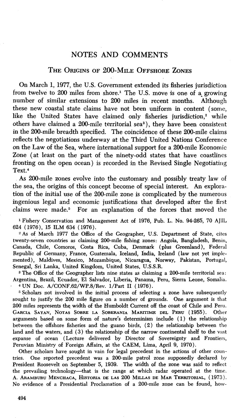
1 Fishery Conservation and Management Act of 1976, Pub. L. No. 94-265, 70 AJIL 624 (1976), 15 ILM 634 (1976).
2 As of March 1977 the Office of the Geographer, U.S. Department of State, cites twenty-seven countries as claiming 200-mile fishing zones: Angola, Bangladesh, Benin, Canada, Chile, Comoros, Costa Rica, Cuba, Denmark (plus Greenland), Federal Republic of Germany, France, Guatemala, Iceland, India, Ireland (law not yet implemented), Maldives, Mexico, Mozambique, Nicaragua, Norway, Pakistan, Portugal, Senegal, Sri Lanka, United Kingdom, United States, U.S.S.R.
3 The Office of the Geographer lists nine states as claiming a 200-mile territorial sea: Argentina, Brazil, Ecuador, El Salvador, Liberia, Panama, Peru, Sierra Leone, Somalia.
4 UN Doc. A/CONF.62/WP.8/Rev. 1/Part II (1976).
5 Scholars not involved in the initial process of selecting a zone have subsequently sought to justify the 200 mile figure on a number of grounds. One argument is that 200 miles represents the. width of the Humboldt Current off the coast of Chile and Peru. Garcia Sayan, Notas Sobre La Soberania Maritime Del Peru (1955). Other arguments based on some form of nature's determinism include (1) the relationship between the offshore fisheries and the guano birds, (2) the relationship between the land and the waters, and (3) the relationship of the narrow continental shelf to the vast expanse of ocean (Lecture delivered by Director of Sovereignty and Frontiers, Peruvian Ministry of Foreign Affairs, at the CAEM, Lima, April 9, 1970). Other scholars have sought in vain for legal precedent in the actions of other countries. One reported precedent was a 200-mile patrol zone supposedly declared by President Roosevelt on September 5, 1939. The width of the zone was said to reflect the prevailing technology—that is the range at which radar operated at the time. A. Aramburu Menchaca, Historia De Las 200 Millas De Mar Territorial, (1973). No evidence of a Presidential Proclamation of a 200-mile zone can be found, how ever, in governmental records of the period or in subsequent compilations of U.S. claims to “defensive sea areas,” “maritime control areas,” and “customs enforcement areas” 46 U.S. Naval-War College, Int'l. Law Documents 1948-49 at 157-80 (1950); and U.S. Naval War College, Int'l. Law: Situation And Docs, 1956 at 601- 07 (1957). The President's September 5, 1939 declaration of neutrality refers only to “areas under national jurisdiction.” Proclamation Concerning Neutrality of United States, Exec. Order No. 8223, F. R. Doc. 39-3240. filed Sept. 5, 1939, 4 Fed. Reg. 3809 (1939). Similarly, a subsequent elaboration of naval duties under this proclamation makes no reference to a 200-mile zone (id. 3819-23). Naval duties, as elaborated by the President's secretary, were to include the establishment of a patrol force of at least 150 vessels to provide intelligence on the movements of belligerent submarines and warships. As the patrol force grew, the area covered would be extended gradually “until it has reached the waters adjacent to Puerto Rico, the Antilles and the Canal Zone.” Ultimately the patrol system would operate up to 200 to 300 miles off the U.S. shores. “U.S. Coastal Patrol Swings Into Action,” N.Y. Times, Sept. 7, 1939, at 13. President Roosevelt was explicit that the patrol was merely to gain information and did not determine U.S. territorial limits. He preferred to define America's territorial waters flexibly—as extending “as far as our interests need it to go out.” Press Conference 579, Sept. 15, 1939 in 14 Complete Presidential Press Conferences Of Franklin D. Roosevelt 166-74 (1972). As for the connection between the size of a patrol zone and the state of military technology, it should be noted that the operational range of radar was less than 200 miles in 1939.
6 Presidential Declaration Concerning Continental Shelf, June 23, 1947. UNITED Nations Legislative Series, Laws And Regulations On The Regime Of The High Seas, UN Doc. ST/LEG/Ser.B/1, at 6 (1951); 4 M. Whiteman, Digest Of International Law 794-96 (1965).
7 Declaration of Panama, 1 Dept. State Bull. 331-33 (1939).
8 Presidential Proclamation No. 2667, Concerning the Policy of the United States with Respect to the Natural Resources of the Subsoil and Sea-Bed of the Continental Shelf, 59 Stat. 884 (1945) and Presidential Proclamation No. 2668, Concerning the Policy of the United States with Respect to Coastal Fisheries in Certain Areas of the High Seas, id. 885.
9 Letter to author by Jerman L. Fischer, March 15, 1976.
10 [1944] 2 Foreign Rel. U.S. General: Economic And Social Matters 934 ff. (1967).
11 The first international agreement was negotiated under the auspices of the League of Nations in 1931. Convention for the Regulation of Whaling, Sept. 24, 1931; T.S. No, 880, 49 Stat. 3079, 155 LNTS 349, signed but not ratified by 26 states. The convention was limited to baleen (whale bone) whales and did not fix a total or species limit on harvesting. Then in 1937, an Agreement on the Regulation of Whaling (signed June 8, 1937 by nine governments, T.S. No. 933, 52 Stat. 1460, 190 LNTS 79) introduced several new principles into the conservation of whales. It provided for inspectors, for certain closed areas, for an open season in waters south of 40° latitude from December 8 to March 7, and for a maximum of six months operation per year for any land station. A review conference was held the following year and adopted a protocol amending the 1937 agreement. Protocol Amending the Agreement of 1937, London, June 24, 1938, T.S. No. 944, 53 Stat. 1794, 196 LNTS 131. A further conference was held before the war and adopted several additional recommendations. 1 Dept. State Bull. 37 (1939).
12 The years were not specified in the interests of security but were privately agreed to refer to 1944-45. [1944] 2 Foreign Rel. U.S., supra note 10, at 942-43.
13 Id. -939.
14 Supplementary Protocol Concerning Whaling, signed at London, October 5, 1945; [1946] Gr. Brit. T.S. No. 44 (Cmd. 6941); S. Exec. Doc. J. 79th Cong., 1 Sess., (1945).
15 146 Brit, And For. State Papers 498 (1946); [1946] Gr. Brit. T.S. No. 44 (Cmd. 6941).
16 TIAS No. 1708, 62 Stat. 1577, 161 UNTS 361.
17 [1944] 2 Foreign Rel. U.S., supra note 10, at 936.
18 [1947] 6 Foreign Rel. U.S.: The Far East 195 ff. (1972).
19 Id. 212 ff.
20 TIAS No. 1849, 62 Stat. 1716, 161 UNTS 72.
21 4 Whiteman, supra note 6, at 1056.
22 Story may be found in T. Barros, “Las Doscientos Millas,” Mercurio, (July 19, 1974), also in letter from Jermán Fischer to author, March 15, 1976.
23 Article by J. Bardina, La Semana Internacional (January 1940).
24 Declaration of Panama, supra note 7, at 332. Among the nations represented at the Consultative Meeting of Foreign Ministers of the American Republics, Brazil explicitly declared that “the sea outside territorial waters, only three miles from our coast, … not only is not ours, but in it we are at the mercy of any action contrary to the free and peaceful expansion of our sovereignty …” Id. 333.
25 The U.S. Government was responsible for determining the size of the security zone in the Declaration of Panama. The Office of the Geographer of the Department of State was first asked to draw zones using radii ranging from 300 to 1,000 miles. The 300-mile radius was determined to be adequate and a map embodying this width was sent to President Franklin Roosevelt. Roosevelt personally drew the straight lines linking the outermost points of the 300-mile circles. It was this map, only slightly altered by the Office of the Geographer, that became the officially delineated zone for the Declaration of Panama. For the accurate map and description of its origins, see [1939] 5 Foreign Rel. U.S.: American Republics 35 (1958).
26 President Gonzalez evidenced his enthusiasm for this policy in G. Videla, Memorias 835 (1975).
27 [1948] 9 Foreign Rel. U.S.: The Western Hemisphere 731-32 (1972).
28 B.&R. Smetherman, Territorial Seas And Inter-American Relations 91 (1974).
29 Presidential Decree No. 781 of August 1, 1947. UN Doc. ST/LEG/SER.B/1, supra note 6, at 16; 4 Whiteman, supra note 6, at 797-98.
30 Maritime Hunting and Fishing Law (Decree No. 003, February 22, 1951) Año III, Registro Oficial, No. 756, March 6, 1951 at 6219-20; 4 Whiteman, supra note 6, at 799-800; United Nations Legislative Series, Laws And Regulations On The Regime Of The High Seas, Un Doc. ST/LEG/SER.B/1/Add. 1 (1952).
- 20
- Cited by


