


DEVELOPMENT OF UNDERWATER ARCHAEOLOGY IN MALAYSIA
To comprehend the historical value of past trade activities, it is crucial to discover and excavate marine artifacts. Underwater archaeological exploration and salvage in Malaysia led by Sten Sjostrand (1998–2002) have proven the existence of bilateral relations and market trading between China and India using the South China Sea and Malacca Strait as maritime routes (Sjostrand et al. Reference Sjostrand, Taha and Sahar2006). More than 10 shipwrecks have been discovered in Malaysian waters between 1984 and 2002, including Sabah and Sarawak. Some of the most famous—such as Turiang (~AD 1370), Nanyang (~AD 1380), Longquan (~AD 1400), Royal Nanhai (~AD 1460), Xuande (~AD 1540), Singtai (~AD 1550), Nassau (AD 1606), Risdam (AD 1727), Diana (AD 1817), and the Desaru wrecks (~AD 1845; Brown and Sjostrand Reference Brown and Sjostrand2002; Oii Reference Oii2015)—have been successfully salvaged by government-appointed consultants (Baszley Reference Baszley1999; Zainuddin and Chia Reference Zainuddin and Chia2020). These salvages and other historical facts and evidence show that Malaysian waters were once regarded as important economic trade routes.
Historical records show that the east-coast waters of Peninsular Malaysia served as an important hub for East–West maritime trade (Gibson-Hill Reference Gibson-Hill1949; Jacq-Hergoualc'h Reference Jacq-Hergoualc'h and Hobson2001; Lockard Reference Lockard2010; Nazaruddin and Nasha Reference Nazaruddin and Nasha2015), confirming the existence of vibrant trade activities between the kingdoms of the Malay Archipelago (Kanumoyoso Reference Kanumoyoso2018), such as the Malacca Sultanate (AD 1400–1511), the ancient kingdoms of Southeast Asia (e.g., Sukhothai, AD 1238–1438; Khmer, AD 802–1431), and the Ming Dynasty in China (AD 1368–1644). Past reports have also highlighted the important role played by Malaysian waters in regional trade activities (Baszley Reference Baszley and Bee2003; Bernama 2011; Calò Reference Calò2009; Doraisamy Reference Doraisamy and Hashim1986; Hall Reference Hall1985; Jacq-Hergoualc'h Reference Jacq-Hergoualc'h and Hobson2001). It is therefore highly plausible to assume that many more shipwrecks and artifacts will be discovered in this area in the future.
Between 1980 and 1990, the process of recovering artifacts from shipwrecks in Malaysian waters relied primarily on salvage approaches (Baszley Reference Baszley1999; Zainuddin and Chia Reference Zainuddin and Chia2020). This is due to budget and knowledge limitations as well as profit maximization among consulting companies. Among the famous companies involved in underwater cultural heritage (UCH) salvage in Malaysia are Nanhai Marine Archaeology Sdn. Bhd. and Transea Sdn. Bhd. Flecker (Reference Flecker2002) highlighted that the government's lack of available funds for excavating shipwrecks and recovering artifacts in Southeast Asia has been the major setback for archaeological exploration in Malaysian waters in the past. One positive sign is the involvement of private companies in shipwreck salvage, ensuring that shipwrecks and their cargoes are recorded. However, a resolution from the 2001 UNESCO Convention on the Protection of the Underwater Cultural Heritage in Paris has called for appropriate scientific excavations to ensure that no important information is missed or unrecorded (UNESCO 2001).
From the perspective of UCH research from the UNESCO 2001 Convention, Zainuddin and Chia (Reference Zainuddin and Chia2020) stated that there were two surveys that had been carried out to discover shipwrecks in the waters of the Straits of Malacca and Tanjung Tuan (Malacca) in 2007 and 2014. However, there were no complete records that could be used from both surveys as a reference for the shipwreck excavation process in Malaysia. For that reason, a comprehensive procedure for scientific excavation needs to be appropriately documented to establish a guideline and reference for future shipwreck excavation programs in Malaysian waters.
The accidental discovery of a shipwreck in the waters of Pulau Bidong, Terengganu, has been the catalyst for a proper scientific excavation in Malaysia (Muhamad and Hasrizal Reference Muhamad and Hasrizal2018). This shipwreck was discovered by a local fisherman, Mr. Anjang Jusoh Zazeri, when his fishing gear hooked and raised stoneware sherds several times. This area is known by generations of local fishermen as a good fishing ground with abundant resources, and they expect that the site is an artificial reef or teranas area. Teranas is a local term that refers to submerged natural rock or a hard seabed area rich with commercial fishes. The information about the discovery was conveyed by Mr. Zazeri to the Universiti Malaysia Terengganu (UMT) senior science officer Mr. Baharim Mustapa, and they suggested that his team dive and discover the area. After conducting scuba diving at the suggested location, Mr. Baharim and his team confirmed that there are many artifacts, especially stoneware vases, spread on the seabed. However, due to the lack of knowledge about underwater archaeology at that time, UMT took the initiative to consult the Department of National Heritage (JWN)—the government authority agency on the protection and conservation of UCH in Malaysia—on the appropriate procedure to carry out the underwater excavation program at the site and the handling of postexcavation artifacts. The main concern during the pre-excavation stage was to ensure that every process complied with Malaysian laws and regulations.
The Bidong Shipwreck excavation program is subject to the National Heritage Act 2005. Under this act, underwater cultural heritage refers to “all traces of human existence having a cultural, historical, or archaeological character that have been partially or totally underwater, periodically or continuously, for at least 100 years. These include (a) sites, structures, buildings, artifacts, and human remains, together with their archaeological and natural context; (b) vessels, aircraft, other vehicles or any part thereof, their cargo or other contents, together with their archaeological and natural context; and (c) objects of prehistoric character.” The first phase of the excavation program took place after the Bidong Shipwreck was discovered due to the need for documentation compliance, the need to provide proper excavation training to a team member, and the need to get an excavation license from the Heritage Commissioner.
After the legal process was completed, the first phase of excavation at the Bidong Shipwreck was successfully carried out in October 2017. This was an honor to the first-phase excavation team because 100% of the expertise was local. This shows that the team of local experts was able to conduct a proper excavation based on the established guidelines and Malaysian legislation. This article describes and discusses the discovery and scientific excavation techniques used to recover artifacts from the Bidong Shipwreck. Universiti Malaysia Terengganu (UMT), UZMA Archaeological Research (UAR), and the Department of National Heritage (JWN) have collaborated on this project in the hopes that it will provide a guideline and reference for future scientific excavations in Malaysia. Previously, there was no academic report properly highlighting the detailed procedure of scientific excavation at any underwater cultural heritage site in Malaysian waters.
For the government enforcement agency, the scientific excavation of the Bidong Shipwreck is a turning point for better monitoring the treatment of underwater cultural heritage excavation in Malaysian waters. It will also encourage the conduct of good scientific excavation rather than merely artifact salvage, which will also prevent losing national treasures to the black market. We do sincerely hope that this experience will be repeated and further developed to ensure the safety of national treasures.
The current excavation process conducted in the coastal area of Bidong Island, Terengganu, Malaysia, is an excellent example of the collaboration between a university (UMT), a company (UAR), and a government authority agency (JWN). A collaboration between three different entities can be used as a benchmark for any future underwater excavation in Malaysia. UMT is a public university and has an important role in carrying out studies related to the artifacts of the Bidong Shipwreck. UAR is a nonprofit company established in 2016 that conducts underwater archaeological activities as part of the parent company's corporate social responsibility (CSR). The mission of this company is to enrich the traces of local maritime history and to preserve the cultural heritage. The capabilities of this company include laboratory analysis at UZMA's geological laboratory, scientific data storage, underwater surveys, and technological innovation. The corporate support of this company through the provision of funds and legal advice ensures that any UCH operations comply with applicable legal and regulatory requirements. UAR acted as one of the main financial contributors to this excavation project. The first excavation program was successfully carried out through the important role played by JWN. This agency helped with regulatory compliance, good practice in artifact rescuing, artifact recording, and conservation.
THE STUDY SITE
The Bidong Shipwreck is located approximately 2 and approximately 30 nautical miles from Pulau Bidong and Kuala Terengganu, respectively (Figure 1), with a water depth of 18 m. The Bidong Shipwreck is assumed to be approximately 25 m long and 10 m wide. Its location and depth make it ideal for research, because no complex technical diving system (e.g., rebreathers or nitrox) is required for the excavation. The diving team requires only an ordinary open-circuit diving system using recreational scuba-diving apparatus with appropriate multiple-dive plans. Due to the wreck's location in the open and shallow waters, it is important to protect the shipwreck and artifacts given that this area is potentially exposed to trawling activities, especially from illegal fishing boats.

FIGURE 1. Map showing (a) peninsular Malaysia and (b) the Bidong Shipwreck study area, located in the National Heritage Zone (ground image generated by Google Earth Pro).
Two important steps have been taken by UMT to protect the Bidong Shipwreck and its artifacts, both legally and physically. Through the legal process, an application was made to the Heritage Commissioner for this area to be gazetted as a national heritage protected zone. The approval was obtained in an official letter stating that 1 nm2 of the Bidong Shipwreck area was gazetted as a national heritage protected zone by the Heritage Commissioner on February 2, 2018 (gazetted number P.U.[B] 60), to protect the site from damage caused by any potential activities. Based on Part 9 subsection 2 of the National Heritage Act 2005 for protected zones, no person shall carry out any activity in the protected zone except with approval in writing from the Heritage Commissioner.
For physical protection of the site from the damage of fishing-boat trawling, four illegal and forfeited fishing boats donated by the Malaysian Maritime Enforcement Agency (MMEA) were sunk and placed just outside the protected zone in August 2020 and April 2021. In the future, UMT is planning to apply more forfeited illegal fishing boats from MMEA to protect the Bidong Shipwreck site. The disposed boats can also be used as a part of the training ground for the excavation practices before divers are exposed to the actual archaeological site of the Bidong Shipwreck. This is in line with the aspiration of the Minister of Tourism, Art, and Culture Malaysia and vice chancellor of UMT to establish the first underwater archaeology training center in Malaysia.
SEABED MAPPING
Side-Scan Sonar Mapping
In marine archaeology, side-scan sonar has been ubiquitously used to locate potential archaeological sites and map seabed areas (Ballard Reference Ballard, Jochim, Dickens, Wiseman and El-Baz2007; Bowens Reference Bowens2009; Green Reference Green2004; Plets et al. Reference Plets, Quinn, Forsythe, Westley, Bell, Benetti, McGrath and Robinson2011). Sonar principles, underwater side-scan sonar operations, and sonar designs have been discussed comprehensively by Kinsler and colleagues (Reference Kinsler, Frey, Coppens and Sanders1982), Urick (Reference Urick1975), and Tian (Reference Tian2010). The basic techniques used in the Bidong Shipwreck excavation program followed the guidelines of side-scan sonar, which referred to the “Manual for activities directed at underwater cultural heritage” (Maarleveld et al. Reference Maarleveld, Guérin and Egger2013) as recommended by guidelines to the Annex to the UNESCO (2001) Convention.
During the July 2017 survey, high-resolution acoustic sonar systems, including the Klein 4900 Side Scan Sonar (SSS) system, were used to locate the Bidong Shipwreck and identify the position of unidentified surface objects. SSS data were collected by a vehicle towed approximately 8 m above the seabed at a speed of 4 kn (1.5 m/s); the slant range was 50 m, transmitting at frequencies of 100 kHz and 400 kHz. Figure 2 illustrates the side-scan sonar operations.

FIGURE 2. Side-scan sonar system operations. Figure provided by Azizi Ali.
A differential geographic positioning system (DGPS) was used for navigation, incorporating an OmniSTAR 3200 LR12 DGPS receiver capable of receiving updates at 10 Hz and integrated with HYPACK MAX Survey software. The software received DGPS signals and calculated the offset and layback distances between the side-scan transducer and DGPS antenna. After locating the archaeological target, the researchers conducted a marking procedure using the navigation software. A pair of divers entered the water to confirm the existence of the site. Sonar data were collected and digitized in the field using a Triton Elics data acquisition system. The data were then postprocessed in the office to georeference each record. Then, the records were corrected for distortion and assembled side by side in a mosaic.
Klein data-acquisition software was used to record events in real time during the survey work conducted at the Bidong Shipwreck. The beam-pattern and ping energy from the sonar signal was corrected with slant range using a flat seabed assumption. To produce accurate results, the system was synchronized between sonar data acquisition, the global positioning system (GPS) and navigation systems, and the image-processing method. In line with Lamarche and Lurton (Reference Lamarche and Lurton2018), no absolute decibel (dB) value was emphasized in the backscatter images. The dB is a logarithmic unit or relative unit of measurement ratio of two or more physical quantities of the same dimensions. The dB is equal to one-tenth of a bel (B).
Bidong Shipwreck Imagery
SonarWiz Map mosaic software by Chesapeake Technology Inc. was used to produce mosaic maps, ensuring that all sonar file lines were amalgamated into a single map. This allowed for the analysis of all attributes and sonographic information. These maps made it possible to interpret reliefs of objects by observing the shape of the acoustic shadow formed by the object blocking the trajectory of light. Principally, any object on the seabed will have a different backscatter energy, so it will appear as bright spots in the image with shadows behind it (Blondel Reference Blondel2009). Shadow length served as a proxy to determine the height of objects protruding from the seafloor at a given distance and angle from the transducer.
Archaeological objects were found at the target location, as shown in Figure 3. The sonar unit was deployed close to the seafloor, approximately 8 m from the target object while the team of divers verified the sonar data immediately. The sonar image clearly shows a group of differently sized objects with sharp edges. The area distribution of the Bidong Shipwreck artifacts was estimated at 500 m2. Based on the sonar images obtained, the archaeological team was able to sketch the likely shape of the Bidong Shipwreck (Figure 3).

FIGURE 3. The Bidong Shipwreck captured by the Klein 4900 sonar system. The sonar processed image shows two divers with their bubbles (blue circles) and the artifacts. The red dashed line indicates the likely shape of the Bidong Shipwreck.
SCIENTIFIC EXCAVATION TECHNIQUES
Main-Axis Development and Trench Gridding
The excavation process was designed and implemented based on the SSS image of artifacts distributed on the seafloor. Prefabricated steel joints, each measuring approximately 6 m in length, were used for the main axis line. A mark was painted red and white for every 1 m interval. For the Bidong Shipwreck excavation, the main-axis lines were determined by the laid down direction of the prefabricated steel joints. The main axis lines were set as north–south (y-axis) and east–west (x-axis; Manders and Underwood Reference Manders and Christopher2012). Given that the area was relatively flat outside the potential Bidong Shipwreck cargo, the main axis lines were laid down on the seabed (Figure 4).
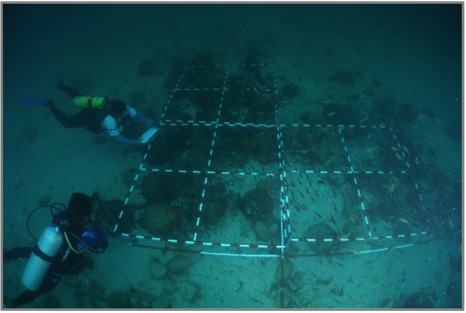
FIGURE 4. The underwater technical team installing the main-axis line at the target point of multiple prefabricated steel joints. Photograph taken from authors' collection.
The main-axis and trench gridding were identified and arranged based on the bathymetry image (Figure 5). The side-scan sonar provided an overall top view of the artifact distribution. The main-axis intersection point was also located. From the first trench, the subaxis line intersected at 8 m north and 10 m west, where most artifacts were concentrated; this was assumed to be the main cargo space of the Bidong Shipwreck. The main reason for the selection of main-axis setup area is to sustain a similar main-axis setup for future excavation programs at the site.

FIGURE 5. The plotted area of the main axis and subaxis, based on the bathymetry image.
Systematic Underwater Data Collection
A prefabricated steel trench structure (approximately 2 m × 2 m) was used to mark the area for archaeological collection. The red and white 10 cm paint marks helped divers identify the location of each artifact. The trench structure was supported by four adjustable legs, one at each corner, which could be extended to any required level. The subaxis intersection provided point guidelines, helping the divers locate trenches accurately. After the work was finished, the team set up grid locations at c5, d5, and e4 (Figure 5).
Underwater technical divers used waterproof paper to record crucial information about the site and its artifacts, guided by the trench setup. Each trench had four quadrants, as illustrated below; each quadrant was 1 m × 1 m (Figure 6). All the artifact data collection, tagging, and salvage work was carried out using these quadrants.

FIGURE 6. The excavation-trench design.
Excavation, Rescuing, and Lifting
This project [T/BSW/S/17(1)] was set as 0 spit, rescuing only artifacts found on the seabed. Intact excavated artifacts and shards were tagged by location in each trench quadrant. In accordance with the “training manual for UNESCO foundation course on the protection and management of underwater cultural heritage in Asia and the Pacific” proposed by Manders and Underwood (Reference Manders and Christopher2012), an artifact is considered a shard if its total body structure is less than 50% complete. All artifacts found were tagged and labeled to their respective quadrants (Figure 7) before being transferred into a special plastic basket (Figure 8a). Subsequently, the basket was added into the custom galvanized iron frame for lifting (Figure 8b). Lifting the artifacts required coordination between the divers, surface swimmers, and onboard team, given that there was no underwater communication system. The lifting frame was raised up from seabed to sea surface via a lift bag. After the lifting frame arrived at the surface, the connection was changed by two well-trained swimmers from the lift bag to the boat's hydraulic winch sling connector (Figure 8c). For the final lifting process, the frame was elevated by hydraulics onto the UMT Discovery II vessel (Figure 8d). Later, the plastic basket that contain labeled artifacts was removed from the lifting frame and transported to the UMT Marine Nature Research Station by speedboat for further treatment and documentation by the on-land team. This was a delicate process, which had to be handled and coordinated appropriately to avoid damaging the artifacts. In some previous excavations from other countries, researchers used underwater communication devices to allow divers and vessel operators to communicate clearly (Dobre Reference Dobre2018). The Bidong Shipwreck excavation lacked the necessary technology to install an underwater communication device. However, experienced team members and proper coordination ensured that the excavation was conducted successfully, without incident.

FIGURE 7. Artifacts marked underwater, using waterproof paper, at the Bidong Shipwreck location. Photograph taken from authors' collection.
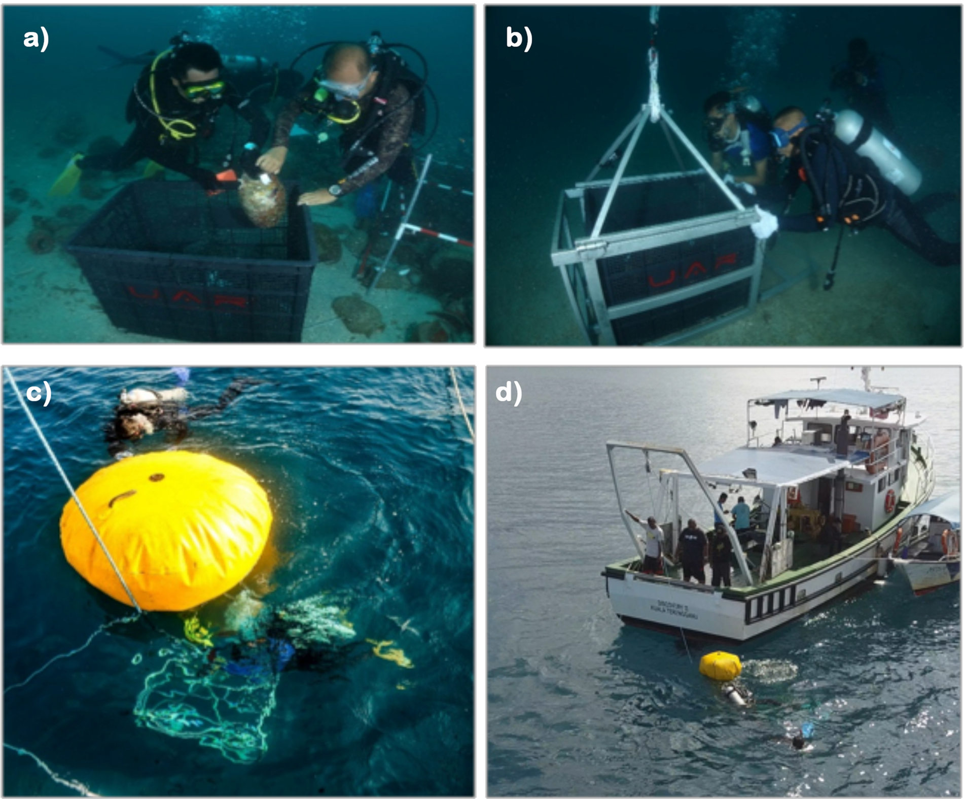
FIGURE 8. Lifting artifacts from the Bidong Shipwreck archaeological site: (a) inserting artifacts into the basket, (b) inserting the basket into the frame, (c) using the lifting buoy, and (d) transferring artifacts into the vessel. Photographs taken from authors' collection.
Analyzing, Registering, and Cataloging Artifacts
In total, 306 artifacts were rescued from the Bidong Shipwreck. Each artifact was cleaned to remove marine material, including fish, shrimp, and benthic organisms; intact coral was not detached from the artifacts. After cleaning, every artifact was analyzed, with its physical dimensions recorded on an artifact registration form, as recommended by UNESCO's training manual (Manders and Underwood Reference Manders and Christopher2012) and JWN. Each registration sheet represented one artifact. A portable photography studio was used to capture high-quality 360° photographs. The artifacts were captured from different angles, including top, bottom, side A, side B, side C, and side D views. To register the artifacts, a tracking-number system was used based on each artifact's original quadrant location at the archaeological site. This format provides immediate information about the origin of each artifact.
After the completion of first-phase excavation in 2017, a full report was submitted to the Heritage Commissioner, and it was approved in 2022. The delayed approval from the Heritage Commissioner was due to the internal process at JWN and the movement control order (MCO) announced by the Malaysia government during COVID-19 in 2020. The submission of the report to the Heritage Commissioner is a part of the legal provisions that were outlined under the National Heritage Act of 2005, which stated that every encounter must be recorded and reported to the Heritage Commissioner. According to Part 9 of underwater cultural heritage, subsection 66 of the act, “any underwater cultural heritage discovered during any survey, salvage or excavation works shall vest in the Commissioner and shall be listed in the Register.”
The initial physical-identification and cross-checking results indicate that the main artifacts from the Bidong Shipwreck are Sawankhalok and Sisachanalai stoneware (Brown Reference Brown2000; Brown and Sjostrand Reference Brown and Sjostrand2002). The patterns and types of ceramics found in the wreckage cargo are similar to those recovered from the Singtai shipwrecks in east Redang Island. However, further analysis must be conducted once the artifacts have undergone a desalination process in the UMT desalination pool. After the completion of the desalination treatment, selected artifacts will be placed in the underwater archaeological gallery at UMT. Permission to conduct preservation and storage of all artifacts rescued from the Bidong Shipwreck was granted by the Heritage Commissioner. However, the preservation procedures and storage of artifacts will be carried out under the full responsibility and budget of UMT. Figure 9 shows eight of the 306 artifacts salvaged from the Bidong Shipwreck; they have been appropriately measured, cataloged, and registered using the system suggested by the JWN.

FIGURE 9. Artifacts of different sizes found in the Bidong Shipwreck. They are believed to be Sawankhalok or Sisachanalai, which originated from the Thai kiln sites in Sukhothai or Sri Satchanalai (or both): (a) large vase (T/BSW/S/17(1)/d5C1), (b) four-eared handle vase (T/BSW/S/17(1)/d5C2), (c) four-eared handle vase T/BSW/S/17(1)/d5C4, (d) small bottle (T/BSW/S/17(1)/d5C5), (e) small bottle with earring (T/BSW/S/17(1)/d5C12), (f) small vase (T/BSW/S/17(1)/c5B8), (g) small bottle (T/BSW/S/17(1)/d5C15), and (h) small bottle T/BSW/S/17(1)/d5C18.
Future Planning
The preserved artifacts will undergo relative comparison and absolute/chronometric analysis to determine the origin and specific time frame of the shipwreck and artifacts. The relative comparison analysis will be carried out by comparing artifacts rescued from the Bidong Shipwreck with several references about Southeast Asian ceramics (e.g., Brown Reference Brown2000; Sjostrand et al. Reference Sjostrand, Taha and Sahar2006). The absolute/chronometric analysis that will be carried out includes radiocarbon analysis of the wood fragments and thermoluminescence (TL) of the ceramics to date the age of shipwreck and artifacts. The wood fragment analysis will be used to identify the tree species used for shipbuilding and the origin of the ship. The analysis of chemical and mineral composition of ceramics will reveal the type of clay composition and the firing temperature in the ceramic manufacturing.
Based on the success of the first-phase excavation, the second phase of the Bidong Shipwreck excavation, which will be partially focusing on the subsurface areas, will be extended. For several years, the plan to carry out the second phase of excavation was delayed due to the COVID-19 movement control order (MCO). The post-pandemic period is the right time to conduct the second phase of excavation. The focus of the second-phase excavation is to identify whether the structure of the Bidong Shipwreck is buried under the surface of the seabed, given that the first-phase excavation only raised the artifacts discovered on the surface and found no sign of the ship structure on the site surface. However, the major issue in conducting a subsurface excavation program is the need for a large budget with high-tech applications. Hopefully, the aspiration to expose the Bidong Shipwreck cargo can be realized so as to see the objects of historical value that have been stored for hundreds of years.
CONCLUSION
The process of excavating, processing, and storing artifacts from the Bidong Shipwreck site survey was the pivotal achievement of this project. This report details several underwater archaeological excavation and rescuing techniques, providing a good-practice case study for future scientific excavations in Malaysia. Approximately 50% of the artifacts were salvaged from six strategic grids. Future excavations can achieve good results by following the trench- creation and artifact-rescue processes detailed here; they can also complete the six remaining strategic grids.
In total, 306 artifacts were analyzed, registered, and cataloged. This was done thoroughly to capture crucial information, which was recorded appropriately. A well-developed inventory-tracking system has ensured that all registered artifacts are stored in desalination pools with a tracking system, making it easy to retrieve them for future reference. There will be numerous opportunities to expand the team's scale and capabilities for future projects. Potential projects include confirming the shipwreck bow and stern location and excavating subsurface artifacts. Excavation work and appropriate equipment are needed to ensure the success of such future projects.
There is a huge opportunity to use the discovered artifacts from the Bidong Shipwreck for future studies, which involve multidisciplinary knowledge of social and applied sciences. Findings from those studies will provide an additional value to the discovery of the Bidong Shipwreck. Perhaps the origin and specific time interval of the Bidong Shipwreck and artifacts can be answered through additional multidisciplinary studies.
From a wider perspective, the procedure that has been designed and carried out in the first-phase excavation project is important because it was the first exercise of its kind in Malaysia, and it is an initative by which to create good practice for future excavation of UCHs in Malaysia. All processes, from initial planning to artifact retrieval, were carried out in accordance with the Annex of the UNESCO (2001) Convention, with some modifications, expert advice, and strict monitoring from JWN. Therefore, the report of this project provides a comprehensive guideline for any instituition or individual planning for future excavation of UCH in Malaysian waters. This study will also help the JWN as the authority agency in Malaysia to set benchmarking and an assessment model for any application to conduct UCH excavation programs in Malaysian waters. Furthermore, it has definitely prevented the loss of national treasures to third parties without the knowledge of government and enforcement agencies.
Acknowledgments
An excavation permit (JWN.PP.600/3/3) at the underwater archaeological site of the Bidong Shipwreck was granted by the Malaysian Heritage Commissioner on July 25, 2017. We would like to thank the technical team of the Repository Research Center of the Institute of Oceanography and Environment (INOS); professional scuba divers Kamaruzzaman Arifin, Mohd Sahimi Abdul Rashid, Mohd Forzi Zahari, Syed Ahmad Rizal Tuan Nik, and Mohd Fauzi Romeli; boat crews of UMT Discovery II; and the land-support team from UAR, UMT, and the State Museum of Terengganu. The authors also appreciated professional consultation given by associate professor Dr. Asyaari Muhamad from the Institute of the Malay World (ATMA), Universiti Kebangsaan Malaysia (UKM); and Mr. Aziz Abd Rashid from the Asian Art Museum, Universiti Malaya (UM) regarding maritime history and the type of artifacts discovered at the Bidong Shipwreck.
Funding Statement
This work was supported by the strategic research grant of UMT (UMT/PPPI/2-2/2/17-62), and the major portion of the excavation was funded by UZMA Berhad via UZMA Archaeological Research (UAR).
Data Availability Statement
No original data were used.
Competing Interests
The authors declare none.


