


Introduction
Mobility is axiomatic in human behaviour, from mobile hunting and gathering to migration, trade, pilgrimage and colonialism. Recent archaeological emphasis on mobility has sought to reanimate a static record of the past, founded on fixed tangible elements excavated from particular places, with the patterns of movement of ideas, technologies, material culture and people between those places (e.g. Bell & Leary Reference Bell and Leary2020). In this article we examine mobility as the decisive factor in defining socio-economic dependencies in one of the cradles of agriculture and so-called pristine civilisation: the central Andean region. The Andes are an ideal theatre for an archaeology of mobility because their extreme topography compresses resource zones of enormous vertical diversity across short horizontal distances. Over millennia, this has induced communities to configure themselves so as to secure access to a range of agricultural and other products across those altitudinal tiers. Moreover, the Andes span tropical latitudes so that cultivation and dense populations can be sustained even at great altitudes (see Figure 1 and Pulgar Vidal's (Reference Pulgar Vidal1981) classification of ecological zones).
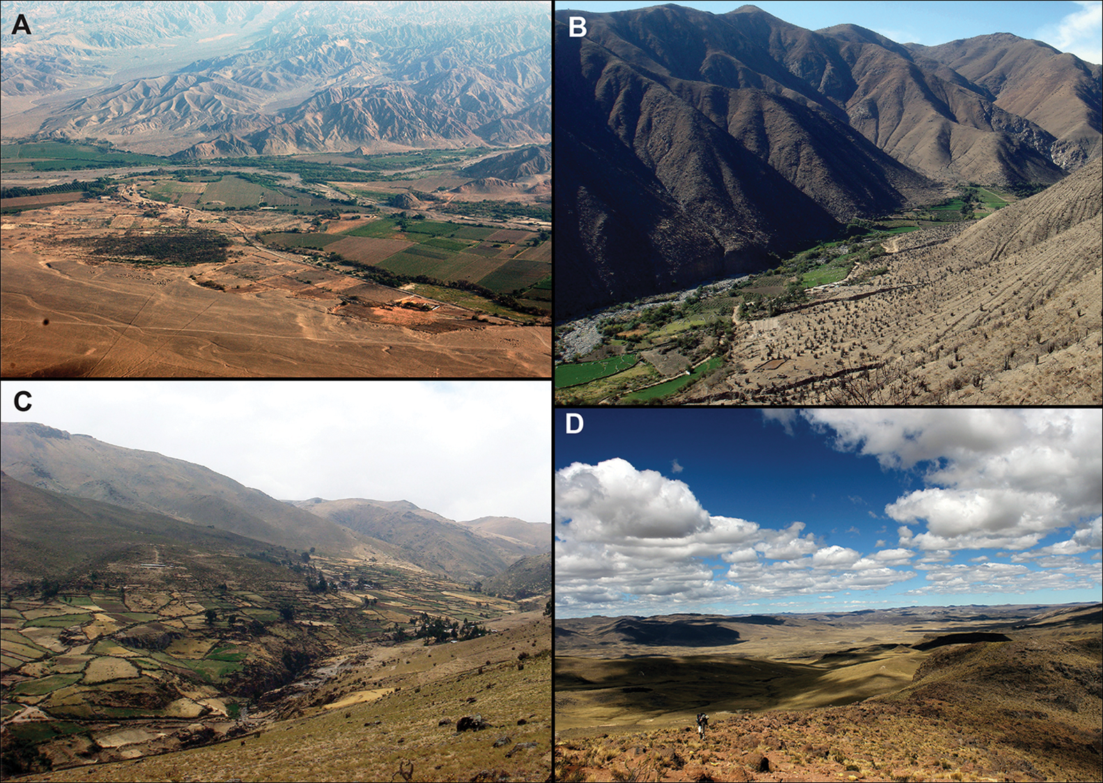
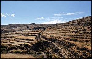
Figure 1. Landscapes across Andean transects in the study area: A) coastal desert and riverine oases (0–500m asl), Ica Valley (photograph by D.G. Beresford-Jones); B) maritime yunga (500–2300m asl), Palpa Valley; C) Quencha intermontane valley (2300–3500m asl), Viscas Valley; D) puna grasslands in Ayacucho highlands, near Quispisisa (above 4000m asl) (photographs B–D by C. Mader).
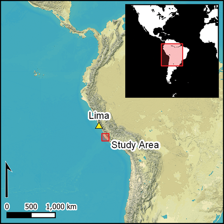
We examine Andean mobility by combining findings from two recent studies of entire Andean watersheds: the German Archaeological Institute's (DAI) Nasca-Palpa Archaeological Project of the northern Río Grande de Nasca, and Cambridge University's One River Project of the Río Ica drainage. Together these projects encompass the heart of Peru's south coast ‘culture area’ and its previously unsurveyed adjacent highlands, providing the regional-scale necessary for an archaeology of mobility (Figure 2).
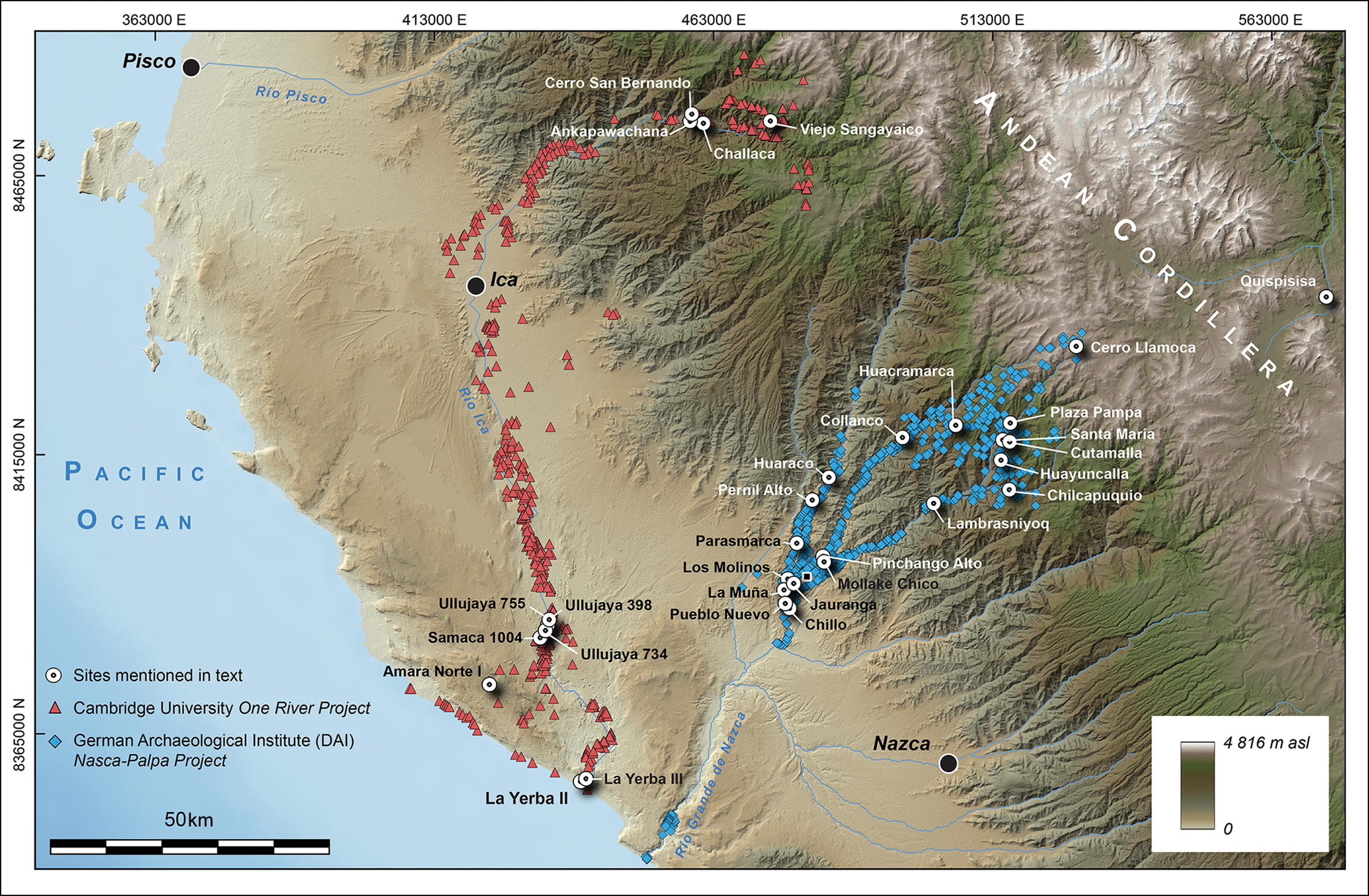
Figure 2. Map of the study area in southern Peru (figure by M. Lang).
The full-coverage methods of these projects provide a record of sites, paths and roads, including the remains of the Inca Qhapaq Ñan road system (Figure 3). Here, we use that framework as context for the analyses of obsidian lithics, stable isotope data of human and camelid remains and evidence of pastoralist systems to explore the origins and development of mobility across two complete altitudinal transects. We argue that these changing patterns of mobility offer a new way of defining the Andean ‘Horizons’, which have long dominated concepts of periodisation, but which remain much debated.
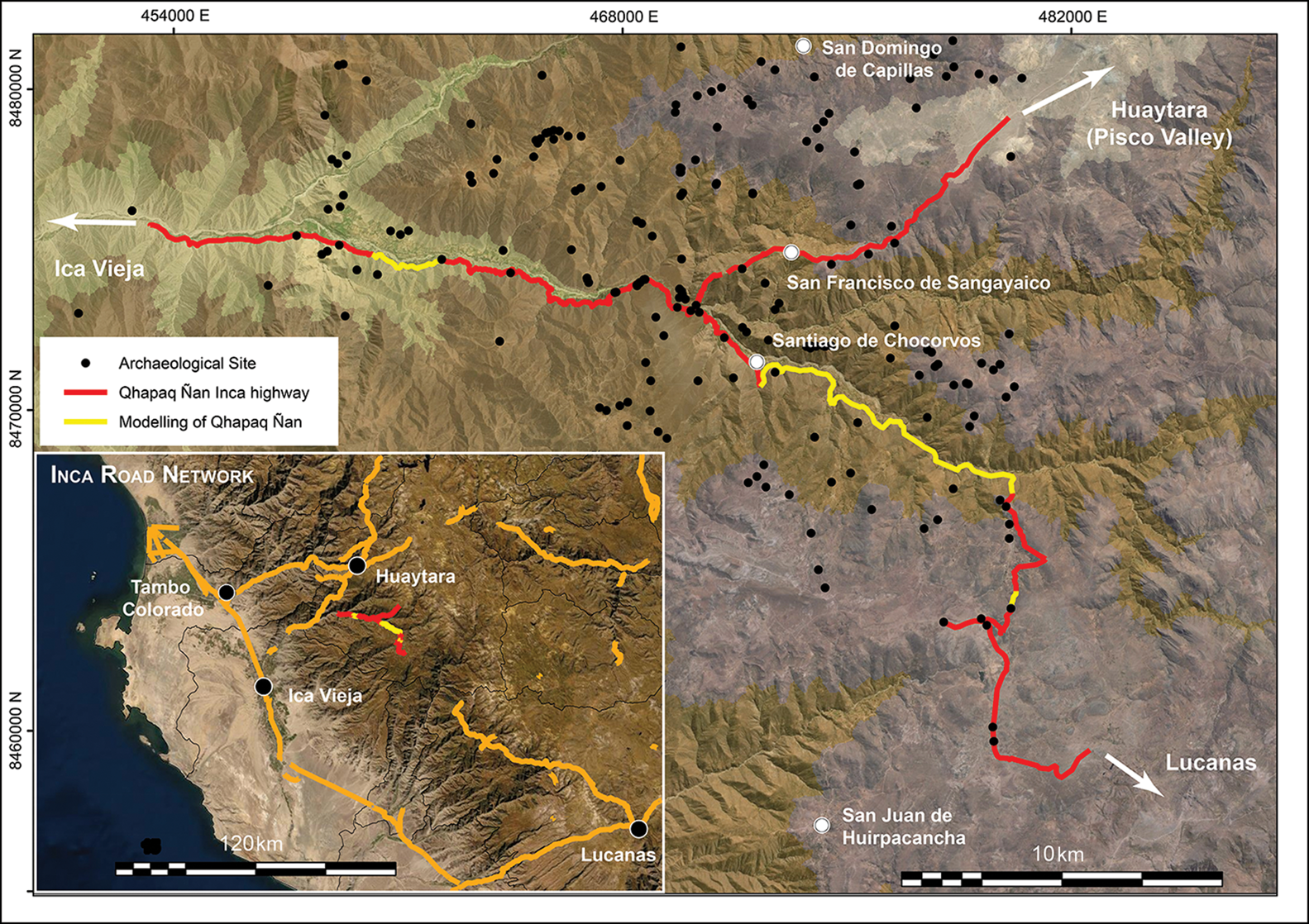
Figure 3. Inca Qhapaq Ñan roads surveyed and modelled within the study area (figure by L.V.J. Coll).
Three successive Horizons are manifest in the Andean archaeological record, each with highland origins. The last of these—the Inca Empire, or Late Horizon, encountered by the Spanish in the sixteenth century AD—stretched more than 4000km from Ecuador to Argentina and Chile, with its capital in Cuzco in the southern highlands of Peru (see Figure 4). Some 500 years earlier, a Wari Middle Horizon had cast influence across a somewhat smaller area of the central Andes from its heartland in Ayacucho, south-central Peru. The Early Horizon of the first millennium BC was a vaguer sphere of influence—perhaps of a proselytising religious cult—centred on Chavín de Huantar in Ancash, north-central Peru. This periodisation had been preceded by many millennia of the so-called Archaic Period, during which transitions akin to the Mesolithic and Neolithic had laid the foundations for complex society in the Andean region.

Figure 4. Chronogram and mobility patterns for the study area (figure by D.G. Beresford-Jones, C. Mader and K.J. Lane).
The southern Peru study area
The south coast of Peru, comprising the Pisco, Ica, Río Grande de Nasca and Acarí river valleys, has a distinctive geomorphology, climate and hydrology compared with the rest of the Peruvian coast. For much of prehistory, it was also characterised by distinctive cultural trajectories, including Paracas and Nasca, and the widely used chronology for all central Andean prehistory (Rowe Reference Rowe, Rowe and Menzel1967) (Figure 4) is based on the ceramic sequence of the Ica Valley. The highland hinterlands of these valleys, however, have remained largely unexplored archaeologically, until now.
Over the last two decades, the Nasca-Palpa and One River projects have surveyed and investigated the archaeology of the northern Río Grande de Nasca and Río Ica drainages, from their headwaters at over 4500m asl, to their estuaries on the Pacific coast. Together they have recorded 1860 sites spanning 10 millennia from the Early Archaic to the Inca Late Horizon (Unkel et al. Reference Unkel2012; Soßna Reference Soßna2015; Haburaj et al. Reference Haburaj2017), investigating settlement patterns, palaeoclimate, human-environment interactions and socio-economic organisation (e.g. Reindel Reference Reindel, Reindel and Wagner2009; Beresford-Jones Reference Beresford-Jones2011; Schittek et al. Reference Schittek2015; Mader Reference Mader2019). Archaeological sites across these two Andean transects that are discussed here (Figure 2) are shown in Table 1.
Table 1. Archaeological sites discussed in the text.

Indicators of mobility
Combining the findings of these two projects provides a high-resolution, regional-scale archaeological survey of the adjacent watersheds of the Río Ica and northern Río Grande de Nasca, which together comprise the heartland of the south Andean culture area (herein, the ‘study area’). Various indicators of mobility include: roads and associated infrastructure; camelid caravan and pastoralism sites, such as caravanserais, campsites, apachetas/landmarks, petroglyphs and corrals; and materials moved from their places of origin, including lithics, metals, marine resources, agricultural and camelid products, textiles and salt (Figures 3 & 5). Here we emphasise two datasets with contrasting implications for understanding mobility across this altitudinal transect: obsidian lithics and stable isotope data from human hair.
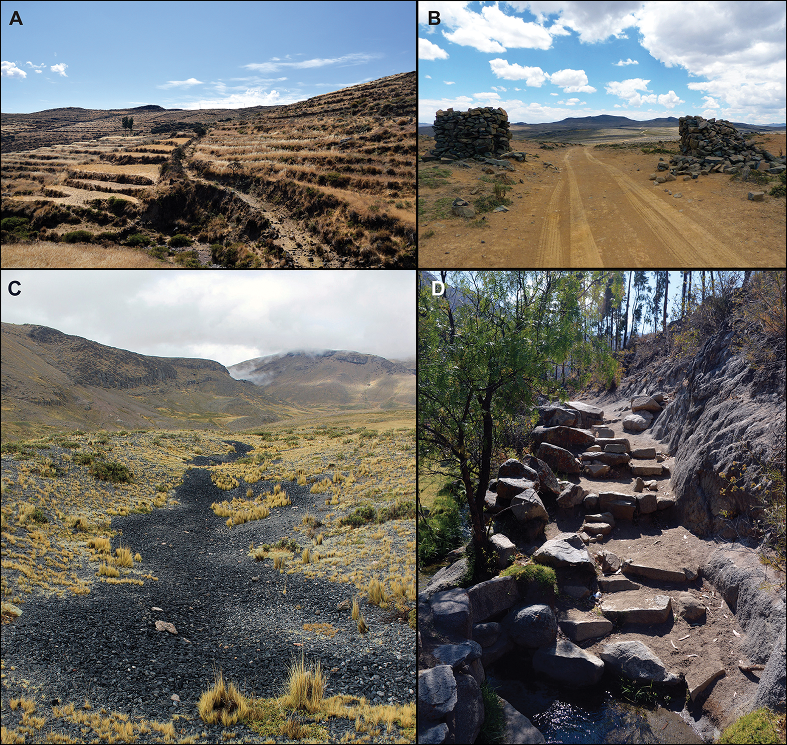
Figure 5. Selected markers of mobility mentioned in the text: A) the Qhapaq Ñan Inca road passing through agricultural terraces at San Miguel de Curis, 3500m asl, Ica Valley; B) Apachetas marking a pass on a modern road at Pampa de Maccarancca, 4200m asl, on the route of the original Inca highway; C) exposed obsidian at the Jichja Parco source at Quispissa, 410m asl (photograph by C. Mader); D) part of the Qhapaq Ñan Inca road at Puente San Pedro, 2500m asl, Ica Valley (photographs A, B & D by K.J. Lane).
Analyses of obsidian artefacts
Obsidian can be traced to particular geological sources and is therefore a common proxy of mobility in the past. Furthermore, the lithic reduction sequence (or chaîne opératoire) used to produce obsidian artefacts can also offer insights into mobility between raw material procurement and the final disposal of used tools (Mader Reference Mader2019). Figure 6 shows the results of geochemical sourcing of 386 obsidian artefacts from Archaic (n = 65), Early Horizon (n = 170), Early Intermediate (n = 56), Middle Horizon (n = 80), Late Intermediate (n =12) and Late Horizon (n = 3) archaeological contexts (Chauca et al. Reference Chauca2019; Gräfingholt Reference Gräfingholt2022). Figure 7 shows the distribution of products and waste resulting from the obsidian lithic reduction sequence during the Early Horizon (for details of methods and results, see the online supplementary material (OSM)).

Figure 6. Obsidian sources by time period. n represents the number of obsidian artefacts analysed (figure by D.G. Beresford-Jones and C. Mader).
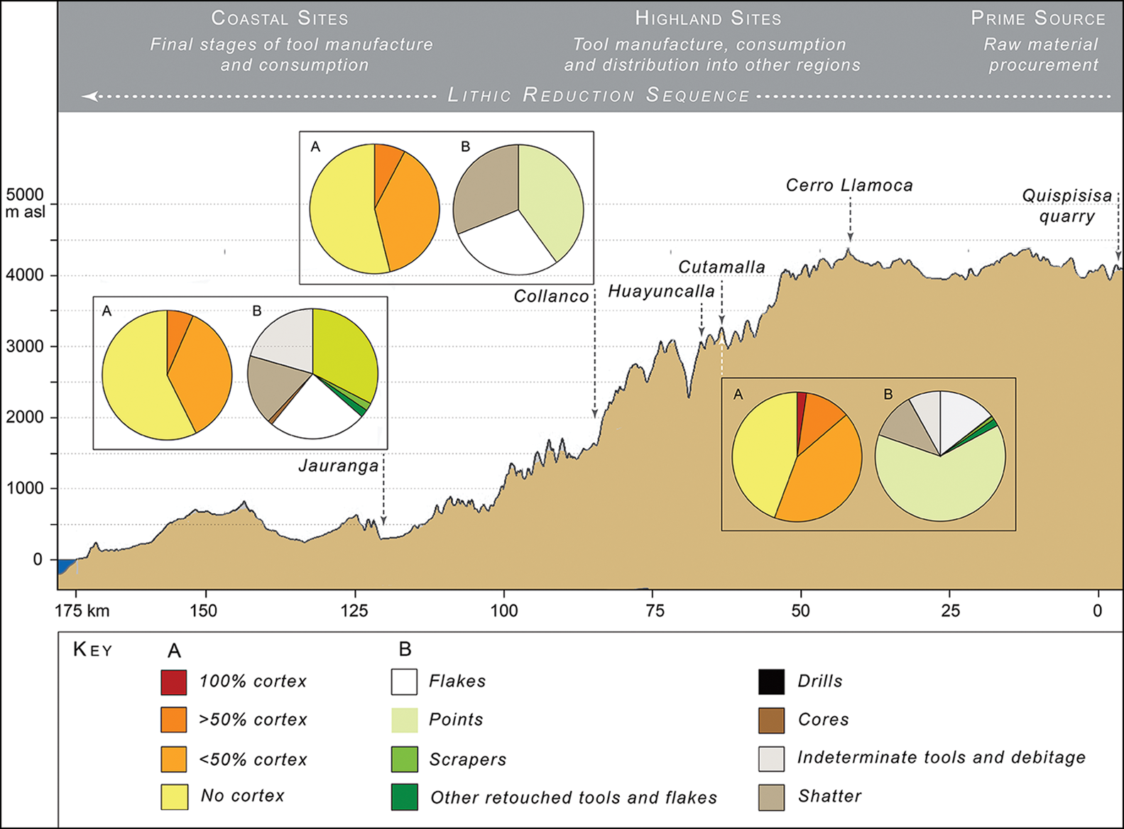
Figure 7. Distribution of the obsidian lithic reduction sequence across the study area during the Early Horizon (figure by D.G. Beresford-Jones and C. Mader).
Stable isotope analyses
Stable isotope ratios in human and animal remains can be used to assess past diet and mobility, and are particularly effective in contexts with extreme altitudinal difference, such as the Andes. Together, the two projects have undertaken stable isotopic analyses on the remains of 537 humans and 154 camelids (Horn et al. Reference Horn, Reindel and Wagner2009; Cadwallader Reference Cadwallader2013; Mader et al. Reference Mader2018). Here we emphasise data from rarely preserved human hair, in which isotopic composition can reveal short-term variations in diet and mobility that are obscured by the averaging of isotopic signatures in bone and teeth tissue. Scalp hairs of between 140mm and 500mm were analysed in 10mm segments from 22 individuals interred in Middle Horizon and Late Intermediate mortuary contexts at Ullujaya, lower Ica Valley (Cadwallader et al. Reference Cadwallader2018a). As hair grows at approximately 10mm a month, these represent individual monthly dietary histories over at least one, and up to four years (Figures 8 & 9; for details of methods and results, see the OSM).

Figure 8. Carbon (top) and nitrogen (bottom) isotopic variation in segmented hair samples representing at least 12 months' growth from 11 adults in Middle Horizon interments at Ullujaya, lower Ica Valley. Data split into two groups using Ward's Method of cluster analysis with intra-individual carbon variations >1.5‰ (A) and with intra-individual carbon variations <1.5‰ (B) along the length of the hair. Breaks in lines are due to insufficient isotope data for certain hair segments (figure by L. Cadwallader and D.G. Beresford-Jones).

Figure 9. Carbon (top) and nitrogen (bottom) isotopic variation in segmented hair samples representing at least 12 months' growth from 11 adults in Late Intermediate interments at Samaca, lower Ica Valley. Data split into two groups using Ward's Method of cluster analysis with intra-individual carbon variations >1.8‰ (A) and with intra-individual carbon variations <1.6‰ (B) along the length of the hair (figure by L. Cadwallader and D.G. Beresford-Jones).
Mobility across two Andean transects of southern Peru
Deep-time transformations of dependency and mobility
Within the study area, isotopic, osteological and other data point to increased residential sedentism at the interface of particularly rich marine and terrestrial habitats, leading to the emergence of the earliest permanent villages, such as La Yerba III (6485–5893 cal BP) and Pernil Alto (5750–5250 cal BP). Their inhabitants exploited these habitats through rounds of seasonal logistical mobility, supplemented by incipient agriculture (Beresford-Jones et al. Reference Beresford-Jones2018, Reference Beresford-Jones2021; Gorbahn Reference Gorbahn2020). For instance, 85 per cent of hunted wild guanaco (Lama guanicoe) camelid bones recorded at La Yerba III are of meatier hind leg parts, suggesting that these animals were butchered at distant kill sites in riverine or lomas (fog) oases. Before riverine oases were transformed by farming, herds of wild guanaco likely migrated between lomas in winter and the western Andean slopes in summer, shaping seasonal hunt mobility (Beresford-Jones et al. Reference Beresford-Jones2021). In turn, the hunting of migrating wild animals unfolded through camelid domestication into pastoral transhumance and herding (e.g. Wheeler Reference Wheeler1995).
Although there is currently no consensus as to when and where the domestication of llamas and alpacas took place, today their pastoral exploitation is restricted to the high-altitude, treeless puna plateau, above the limits of agriculture, at around 4000m asl. This marginality is, however, the outcome of the introduction of Old World animals such as horses, mules, sheep and goats. In the pre-Columbian past, herding extended across the Andes from the Pacific coast to the Amazonian lowlands. Camelid remains proliferate in the archaeological record on the coast here from the Early Horizon onwards (e.g. Bonavia Reference Bonavia2008; Cadwallader et al. Reference Cadwallader, Arce and Beresford-Jones2018b). Strontium isotope data suggest significant changes in the spatial organisation of herding between the Early Horizon and subsequent Early Intermediate Period (Horn et al. Reference Horn, Reindel and Wagner2009; Mader et al. Reference Mader2018; see below). Today, pastoralist transhumance continues between the coast and the Andean footslopes, albeit with camelids replaced by Old World sheep and goats: a powerful proxy for the low-altitude camelid pastoralism that prevailed in the pre-Columbian past.
Mobility was, moreover, also critical to plant domestication because moving plants beyond their native distribution selects for genetic factors controlling harvest timing and seed dispersal: in effect, incipient domestication. Vavilov (Reference Vavilov1992) first postulated mountainous regions as foci of agricultural origins, and perhaps nowhere else on Earth has ecological diversity more compressed over relatively short horizontal distances than in the Andes. Some of the oldest remains of important crops with Amazonian wild ancestors are recorded in our study area, including sweet potato (Ipomoea batatas) dated to 5800 cal BP at Pernil Alto, and lima beans (Phaseolus lunatus) dated to 6270–5996 cal BP at La Yerba III and 5268–5036 cal BP at Pernil Alto (Beresford-Jones et al. Reference Beresford-Jones2018; Gorbahn Reference Gorbahn2020). Mobility over these landscapes of ecological diversity thus drove processes of both animal and plant domestication over the millennia of the Archaic Period.
This mobility is evident in the proxy-indicator of obsidian lithics—conspicuous at Archaic sites in the study area such as La Yerba III, Pernil Alto and Amara Norte I (Chauca et al. Reference Chauca2019; Gorbahn Reference Gorbahn2020). Of the obsidian artefacts analysed from these coastal sites, 97 per cent originated from the Quispisisa source, located 160km away in the high Andes, at 4100m asl (cf. Eerkens et al. Reference Eerkens2010) (Figures 5C & 6). The precise mechanisms of exchange by which these materials arrived on the coast are unknown, but human isotopic data hint at direct interactions between coast and sierra, even at these great time depths (Beresford-Jones et al. Reference Beresford-Jones2021).
Andean Horizons defined by an archaeology of mobility
Following the foundational changes in mobility that took place in the Archaic Period, the archaeological record in the study area resonates with that of the wider Andean region, long divided according to ‘Horizons’ and ‘Intermediate Periods’. These Horizons were once interpreted in the historical light of their final manifestation—the Inca Empire—as expansionist, highland imperial hegemonies, an orthodoxy now much critiqued in favour of more economically, religiously or politically diverse interpretations (e.g. Lorandi Reference Lorandi, Murra, Wachtel and Revel1986; Jennings Reference Jennings2010). We argue that distinctive patterns of mobility offer new perspectives on how these Horizons and Intermediate Periods contrasted, beginning with a significant revision in understanding of the Early Horizon in the study area.
Defined by the integration of religious iconography emanating from highland sites such as Chavín de Huántar some 600km to the north, the first-millennium BC Early Horizon culminated in our study area with transformation into Paracas—long considered to be a coastal cultural phenomenon. High-resolution survey and excavations of the study area's highlands, however, reveal a continuous Paracas settlement pattern extending across the entire western Andean flank, from the Pacific littoral to the high puna above 4000m asl (Soßna Reference Soßna2015). Moreover, patterns of mobility, evidenced by the long-distance exchange of raw materials and end products suggest direct access to, and control of, those resources across all the ecological tiers of the western Andes during the Early Horizon (Mader Reference Mader2019; Mader et al. Reference Mader2022).
Although the Quispisisa quarry was established as the principal source of obsidian from the Archaic Period onwards, by the Early Horizon it is evident that obsidian lithics from other and more distant sources were also available (pace Eerkens et al. Reference Eerkens2010), implying even longer-distance exchange and movement. Of 170 obsidian artefacts analysed from Early Horizon sites, 93 per cent originated from Quispisisa, while others apparently came from Puzolana and Lisahuacho in Peru and from Cerro Huenul, Argentina, and Callejones, Ecuador, some 180km, 200km, 2420km and 1660km, respectively, from the study area (Figure 6). There are fewer available data on obsidian artefacts from subsequent time periods, but the results suggest that this relative diversity of obsidian sources persisted in the later Horizon periods (Gräfingholt Reference Gräfingholt2022).
The Early Horizon data also evidence the earliest systematic patterning of obsidian distribution, tool production and use across this Andean transect (Figure 7). Early stages of lithic reduction took place at the Quispisisa quarry prior to transport to strategic centres, such as Cutamalla and Huayuncalla, each over 60km from Quispisisa as the condor flies. High densities of debitage at these sites suggest that most obsidian tools were manufactured here for subsequent distribution onwards. Lithics then underwent further reduction during their journeys to their ultimate destinations, which were driven by demand at coastal Paracas settlements such as Jauranga and Samaca 1004. Some final stages of tool fabrication took place at these coastal sites, albeit on only a limited scale.
The Early Horizon also offers the first evidence of significant numbers of herded, domesticated camelids (as distinct from hunted wild guanaco) at coastal sites such as Jauranga and Samaca 1004. This is hardly coincidental since these were the pack animals of the caravans that articulated mobility and trade, as well as sources of dietary protein and critical raw materials in many production chains—not least the brilliantly dyed camelid fibres in the corpus of famous Paracas textiles. Rather than Murra's (e.g. Reference Murra, Masuda, Shimada and Morris1985) ‘vertical archipelago’ model, whereby different communities attained direct access to a diversity of resources by structuring themselves in mosaics of colonies across altitudinal tiers, the evidence from our study area suggests that, during the Early Horizon, ecological complementarity was attained by long-distance exchange throughout an entirely Paracas landscape—termed, ‘economic directness’ by Mader (Reference Mader2019).
The end of the Paracas Period was extremely dynamic, characterised by population growth and apparently widespread violence (Soßna Reference Soßna2015), which defined the trajectory of the subsequent Nasca Early Intermediate Period (Reindel et al. Reference Reindel, Isla, Gorbahn and Otten2015; Cadwallader et al. Reference Cadwallader, Arce and Beresford-Jones2018b). Our findings suggest that this transition also entailed a marked dislocation between coastal and highland settlement, in turn calling for new modes of exchange and interaction between them (Soßna Reference Soßna2015; Lane et al. Reference Lane2017). Strontium isotope analyses of camelid teeth from the Paracas Period on the coast in the Palpa Valley suggest that most animals had originally been reared in the highlands (Mader et al. Reference Mader2018), whereas isotopic data for the subsequent Nasca Early Intermediate Period suggest camelid breeding and herding—almost certainly of llama—on the coast (Horn et al. Reference Horn, Reindel and Wagner2009). Camelid remains are evident in many coastal Nasca contexts (e.g. Bonavia Reference Bonavia2008), including adults and neonates at Marcaya and Ullujaya in the lower Ica Valley (Vaughn Reference Vaughn2009; Cadwallader et al. Reference Cadwallader, Arce and Beresford-Jones2018b), which are typically taken as indicators of local herding.
With the transition from the Early Intermediate to the Middle Horizon, coastal–highland interactions were again transformed, this time by Wari expansion out of the adjacent Ayacucho highlands. While evidence for Wari in our study area is particularly strong (Isla & Reindel Reference Isla and Reindel2014; Soßna Reference Soßna2015; Haburaj et al. Reference Haburaj2017; Cadwallader et al. Reference Cadwallader2018a; Conlee Reference Conlee2021), exactly how Wari power manifested here, and elsewhere in the Andes, remains much debated (e.g. Jennings Reference Jennings2010).
Insights into differing patterns of mobility at this time may, however, come from the stable isotope evidence from hair samples of individuals buried in Middle Horizon and Late Intermediate Period mortuary contexts at Ullujaya in the lower Ica Valley. These data suggest that, for both time periods, the diets of some individuals varied little (Figures 8B & 9B), while others experienced significant dietary cycles over at least one, and up to four years (Figures 8A & 9A). There are many possible reasons for such dietary variations, including seasonality of harvests, cultural or religious observances, and social or gender distinctions (see e.g. McCool et al. Reference McCool, Anderson and Kennett2020). Yet, while our sample sizes are small, these dietary distinctions are not obviously correlated with, for instance, age or sex. Nor is it clear why factors such as harvest seasonality, for instance, would affect certain individuals but not others (for further details, see Cadwallader Reference Cadwallader2013). Rather, the most parsimonious explanation for the differences observed is that some individuals were much more mobile than others. While mobility is frequently inferred from diverse proxies like obsidian, such direct evidence for the movement of individuals—and indeed for differential mobilities within populations—is rare.
Finer-grained distinctions in these data may suggest differences between the patterns of mobility in the Middle Horizon and the Late Intermediate Period. For instance, while the intra-individual variations in δ13C and δ15N isotopic values are not correlated in the hairs of Middle Horizon individuals inferred to be mobile (Figure 8A), they are significantly positively correlated in those of mobile Late Intermediate individuals (Figure 9A; see also the OSM). In light of other archaeological evidence for camelid caravans moving significant quantities of marine foods inland from large sites on the coast, such as L-3 on the Rio Ica estuary (and cf. Siveroni Reference Siveroni2017), this correlation could be interpreted as reflecting the periodic inclusion of marine foods in these Late Intermediate diets. In mobile Middle Horizon individuals, the contrasting absence of a relationship between intra-individual variations of δ13C and δ15N could be interpreted as the consequence of dietary variations arising from mobility across different Andean altitudinal tiers (Tieszen & Chapman Reference Tieszen and Chapman1992; Cadwallader Reference Cadwallader2013; Webb et al. Reference Webb, White and Longstaffe2013). In other words, while the Middle Horizon data would reflect—for certain people buried in the lower valley—patterns of direct mobility into the Andean highlands, the data for the subsequent Late Intermediate Period likely reflect more constrained patterns of mobility within the coastal plain.
The final epoch of Andean prehistory—the Inca Late Horizon—is defined in our study area, as across the Andes, by one of the most unmistakable archaeological markers of mobility: the famous Qhapaq Ñan imperial highway system (Figure 5A–B & D). Fragments of the network of Inca roads are preserved that once linked Ica Vieja on the coast with the highlands and the important Inca site of Lucanas, Ayacucho, while further north up the coast they connected Pisco and the main Qhapaq Ñan highway that ran from the Inca administrative centre of Tambo Colorado up to Huaytara, and eventually on to Cuzco itself (Figure 3). While Inca roads are surely the most conspicuous testament to past mobility, our study shows them to be only the culmination of much deeper time patterns that unfolded here over millennia.
Conclusions
Reconstructing past mobility from a static archaeological record presents challenges that are far from trivial (e.g. Gorbahn Reference Gorbahn2020; Bell & Leary Reference Bell and Leary2020). As Kelly (Reference Kelly1992: 43) notes, archaeologists have long had “difficulty identifying forms and levels of mobility”. For while the distribution of material culture and raw materials can offer proxies of past mobility, they can never entirely discriminate between the various modes of mobility, such as the residential or logistical movement of people, or different types of trade and exchange. These difficulties can only be overcome by considering multiple lines of evidence for contrasting aspects of mobility. Moreover, this must be done over sufficiently ample geographical and diachronic scales.
Bringing together the findings of the Nasca-Palpa and One River projects has provided the regional-scale context necessary for an archaeology of mobility across two western Andean altitudinal transects that extend across more than 4000m of elevation. Beyond the Inca Road system—the ultimate expression of mobility and one of the “most stupendous works ever executed by man” (von Humboldt Reference von Humboldt1816: 198)—multiple lines of evidence from across this area illuminate an archaeology of mobility, the foundations of which originate in the Archaic transition from hunting and gathering to agriculture and pastoralism, and thence in the patterns of long-distance mobility articulated by llama caravans (e.g. Núñez & Dillehay Reference Núñez and Dillehay1995).
We have juxtaposed two types of data to reveal different rhythms of past mobility. Obsidian analyses provide a powerful proxy for mobility through the longue durée, while stable isotope records preserved in human hair capture direct evidence of past mobility over archaeological snapshots of up to 48 months. Across these divergent scales it is plain that the verticality of the Andean landscape, far from hindering mobility, actually drove it, propagating a social dynamism that is evident in the region's ethnography (e.g. Salomon Reference Salomon, Masuda, Shimada and Morris1985), and in archaeological studies elsewhere in the Andes (e.g. Shimada Reference Shimada1982; Parsons et al. Reference Parsons, Hastings and Mendieta1997). Comparable social dynamism is noted in other mountain regions, such as the dry-hill transhumance of Sardinia (Angioni Reference Angioni, Fabietti and Salzman1996), Greece (Campbell Reference Campbell1964) and Turkey (Cribb Reference Cribb1991), but perhaps most strikingly in Alpwirtschaft economies of the Alps and the Himalayas (Rhoades & Thompson Reference Rhoades and Thompson1975). Like those of the Andes, the prehistoric foundations of Alpwirtschaft nomadic pastoralism lie in managing risk through seasonal movement between altitudinal tiers (Reitmaier Reference Reitmaier2017), entailing intimate associations between herding, on the one hand, and farming on the other; for example, through the use of animal manure to fertilise crops and allowing animals to forage on recently harvested fields (cf. Browman Reference Browman, Galaty and Johnson1990).
Different rhythms in these patterns of mobility also offer new perspectives on the traditional Andean periodisation that has long been dominated by the Horizon concept. For whatever their fluctuating economic, religious and political forms, these Andean Horizons each evince far more extensive mobility, within and beyond our study area, than the intervening Intermediate Periods. These, by contrast, reflect less direct patterns of mobility between dislocated highland and coastal societies, albeit also marked by intensified internal interactions between increasing populations. These different rhythms are manifest only through the combination of diverse types of archaeological data. Like the Inca roads that are its ultimate expression, an archaeology of mobility can thus capture how Andean socio-economic dependencies went not in one direction, but in many.
Acknowledgements
We thank all our many colleagues in the DAI Nasca-Palpa Archaeological Project and Cambridge University's One River Project.
Funding statement
The DAI Nasca-Palpa Archaeological Project was supported by, among others, the Swiss Liechtenstein Foundation for Archaeological Research Abroad (SLSA), the German Federal Ministry of Education and Research (BMBF, grant nos 03REX1VP and 01UA0804A) and the German Research Foundation (DFG, grant no. RE 963/9-1). Cambridge University's One River Project was supported by the Leverhulme Trust (grant no. RPG-117), the Gerda Henkel Foundation (grant no. AZ 30/F/17) and the late Don Alberto Benavides de la Quintana (grant no. RG69428).
Supplementary material
To view supplementary material for this article, please visit https://doi.org/10.15184/aqy.2022.168


