


Introduction
The Possession Islands in the Ross Sea are superficially well enough known in the Antarctic community, but with the exception of a few scientific papers and descriptive material on Wikipedia, little has been published and they deserve to be better known. The authors are well acquainted with the islands having separately landed there several times, have access to personal and other public archives, published and unpublished reports, and have interviewed scientists whose research has touched upon the islands. Reviewing this existing knowledge of the long but intermittent history of exploration and occasional scientific endeavour presents an opportunity to set the scene for future studies of this interesting archipelago.
The Possession Islands (Fig. 1) lie less than 10 km east of North Victoria Land and are located between latitude 72o2.50’S–71o 42.10’S and longitude 170o36.00’E–171o 23.80’E some 600 km south of the Antarctic Circle. They are the sites of the first known landing in the Ross Sea sector of Antarctica and the second landing south of the Antarctic Circle which had occurred less than 2 years prior at the Balleny Islands 650 km to the northwest.

Fig. 1. Possession Island archipelago extracted from USGS topographic map Cape Adare Sheet SR 59-60/13 (1968).
We review accounts of the Possession Islands from explorers and whalers between 1841 and 1924 and provide an overview of science programmes since the late 1950s that have included observations of the islands. We also provide a description of the environment on and around the islands compiled from USGS aerial photography (1958, 1961, 1962 and 1983) and satellite imagery (Google Earth, 2010, 2011, 2016 and 2017), descriptions in the scientific literature, weather station data, and our own field observations. In recent decades, the archipelago has also been visited by over a thousand tourists.
The Possession Islands are in the Ross Dependency sector of Antarctica that is claimed by New Zealand as its sovereign territory. The Dependency was established by a British Order in Council and annexed to New Zealand on 30 July 1923. However, New Zealand’s claim is only recognised by Australia, France, Norway and the United Kingdom and New Zealand law only applies to its own citizens in the Dependency.
Naming and misnaming the islands
The Possession Islands archipelago consists of two main islands, two islets and five rocks or pillars (Tables 1 and 2). These names were bestowed between 1841 and 1958 by different explorers (Table 3). Other names for islands and peaks were proposed and not adopted, while the names of the two main islands, Possession and Foyn, have been historically confused in some contexts. The list in Table 2 is a generally accepted set of names, but in some cases these are at odds with official gazetteers.
Table 1. Possession Islands archipelago.

* Detailed topographic survey data not available. Elevations for Possession Island and Foyn Island from US National Science Foundation Division of Polar Programs Reference Elevation Model of Antarctica (2018) and Airbus Defence and Space WorldDEM4Ortho. Other islets interpreted from Nautical Charts and authors’ observations.
Table 2. Possession Islands place names.

Table 3. Possession Islands landings and sightings 1841–1956 (after Headland, Reference Headland2009).

Possession Island was named by Captain J.C. Ross in 1841. In his narrative of the discovery (Ross, Reference Ross1847, Vol.1. p.188–9, p. 194–5), he identified a main island and eight islets, with Possession Island being the largest and northernmost of the group. The chart of the voyage shows five islands and labels the group “Possession Isles” but did not name Possession Island. However, this island is listed in a Geographical Table (ibid. Vol. 1. p. 364).
Henryk Bull, manager of the Norwegian whaling expedition named three of the islands when he saw them in 1895 (Bull, Reference Bull1896, p. 178). The northern island of the group was named Svend Foyn Island, Ross Island the next one south where Captain Ross landed, and Heftye Island as the southernmost of the group (Bull, Reference Bull1896, p. 231–2). Bull had given these names in 1895 and by the time he published his narrative of the expedition he was aware that he could have mis-interpreted Ross’s nomenclature, noting: “There appears to be some doubt whether in our ignorance we did not affix the name Svend Foyn Island to the one to which the name Possession Island was particularly affixed by Sir James. Should this turn out to be correct, cartographers must kindly undo the mischief, and transfer the name [Svend Foyn Island] to the island next in importance” (Bull, Reference Bull1896, p. 198).
Several other names for islands and features in the archipelago were proposed by Bull and other members of the expedition. These included Ross Island and Cape von Mueller (by Bull), Griffith’s Peak and Kernott Peak (by Captain Kristensen), and Archer Peak and “Borchgrevink Peak” (by Carsten Borchgrevink). Anchor Peak, apparently an alternative name for Borchgrevink Peak, was also attributed to Bull, although no evidence for this has been found in his published writings. Of all these suggestions, only Archer Peak has been officially retained. Bull’s nomenclature of Svend Foyn Island has been shortened to Foyn Island.
Bull’s 1896 plea to correctly name Possession and (Svend) Foyn Islands came too late as the misnaming had already been picked up by the President of the Royal Geographical Society (RGS) in London, Clements Markham (Markham, Reference Markham1895). He had access to a report and chart by Leonard Kristensen the captain of Bull’s ship that included the incorrect naming of the islands. The mistake was quickly noted by H. Crummer the Treasurer of the RGS of Australia who declared the name “Possession” Island should solely and religiously be retained (Melbourne Age, 21 September 1895, p. 11), and while Possession Island has mostly been correctly referred to since then, there have been notable exceptions.
The remaining islet and rock names (Kemp Rock, Kristensen Rocks, Bull Island, Favreau Pillar, Dickson Pillar and St Marie Peak) resulted from trimetrogon aerial photography flights by the US Navy in the late 1950s when there was a push to complete topographical mapping of the continent. They were proposed by the US Committee on Antarctic Names and have become widely accepted.
Official names for the island group are in two gazetteers: the New Zealand Gazetteer of Official Geographic Names https:/gazetteer.linz.govt,nz/ and the Scientific Committee on Antarctic Research (SCAR) Composite Gazetteer of Antarctica (CGA) https://data.gov.au/aadc/gaz/scar/ that is the authoritative international gazetteer of Antarctic toponyms. The names in Table 2 are generally consistent with these gazetteers, although some of the latitude longitude references are not accurate, and the narratives also contain errors. For example, the New Zealand entry for the Possessions Islands (group) mis-identifies Foyn and Possession Islands and the Foyn Island entry incorrectly states Ross landed on it in 1841. The origin of Borchgrevink’s name of Archer Peak is listed as either A(lexander) Archer Esq a Queensland, Australia, politician of Norwegian heritage, or Colin Archer the designer of Borchgrevink’s ship the Southern Cross. The latter can be discounted as Borchgrevink had been referring to Archer Peak as early as 1895 (e.g. The Australasian, 30 March 1895, p. 26), but he did not buy the ship until 1897.
The most consequential misnaming is in the Antarctic Treaty list of Historic Places and Monuments. Site #65 is the Antarctic Message Post, Svend Foyn Island. This was added to the list in Measure 4 of the Nineteenth Antarctic Treaty Consultative Meeting in Seoul, South Korea, 1995 and had been proposed by the United Kingdom, New Zealand and Norway to record the message post placed by Henryk Bull and Leonard Kristensen of the ship Antarctic in January 1895. One hundred years after the original event, it perpetuated the misnaming of Foyn and Possession Island as the pole had been erected on Possession Island. Clearly, it is time to finally honour Henyrk Bull’s request and undo the mischief of ascribing the name Foyn Island to Ross’s Possession Island.
Possession Island archipelago
The archipelago is 70 km inside the northwest entrance to the Ross Sea and ∼10 km east of the mainland coast. The nearest land is McCormick Island, 8 km to the NW (Fig. 1) which is attached to the continent by a piedmont glacier flowing off the southern end of the Adare Peninsula. Ridley Beach at Cape Adare, the site of the first wintering on the Antarctic continent is 73 km to the NW, and Cape Hallett where there was the US/New Zealand research station from 1957 to 1973, is 58 km SW. The islands occur in a NNE to SSW alignment over a distance of 9.5 km (Table 1).
Possession Island
Possession Island is 2.3 km long by 1.8 km wide and is low with 60% of its area below 50 m elevation. It has three main topographic features. These are the eastern plateau, central ridge including Archer Peak and the cuspate foreland.
The eastern two-thirds of the island is a gentle plateau nearly half covered by permanent snow/ice. The highest parts at ∼90 m elevation are along the cliffed eastern edge, and it drops down to ∼40 m elevation at the northern and southern ends of the island.
To the west of the plateau is a central ridge covering ∼73 ha. The northern part of the ridge has gentle slopes rising to ∼50 m elevation, while the southern half is spectacularly rugged and rises to ∼95 m in Archer Peak (Figs. 2 and 3). The eastern side of the ridge slopes down to the plateau and forms a central valley that runs the length of the island.

Fig. 2. Possession Island from the northwest with L-R Archer Peak (L), East and West Kristensen Rocks. Rob Suisted Nature’s Pic ©.

Fig. 3. Archer Peak (L) 2020.
The third topographic feature is a 30-ha cuspate foreland (Fig. 3) on the western side of the island. This triangular-shaped landform comprises six or seven SE–NW-oriented beach ridges ∼40 m wide and separated by shallow swales. The crests of the ridges are 8 m to 10 m above sea level. The cuspate foreland, central ridge and valley, and the southern part of the plateau are occupied by nesting Adélie penguins during the breeding season.
Foyn Island
Foyn Island is 2 km long by 1.6 km wide and is a much higher landmass with 57% above 50 m elevation. The highest point is St. Marie Peak (205 m) at the north end of the island (Fig. 5). It has two main topographic features. The main part of the island is a relatively rugged block covering 140 ha and supporting several permanent snow/ice areas. The southwest corner covering ∼45 ha is lower (<45 m) and has gentler topography occupied by penguins where it is ice-free (Fig. 6).

Fig. 4. Oblique view from northwest of the “island cuspate foreland.” Possession Island January 1983. Near circle remains of LCVP, rear circle USCG helicopter.

Fig. 5. Foyn Island from NW. St Marie peak (205 m) on right. Bull Island at rear left. Favreau Pillar extreme left. Wikipedia Commons.
Islets and rocks
Two large rocks have been named as islands, Bull Island and Heftye Island (Fig. 7). They are much smaller than the two main islands (Table 1) and are the southernmost of the Possession Islands group. Bull Island (Fig. 7) is a rugged block some 800 m long by 200 m wide. Heftye Island is a ∼300 m wide rock and was named for financial backers of Bull’s expedition.

Fig. 6. Relatively gentle topography of the southern part of Foyn Island from the southwest 1983. On the right side of the image, the edge of the large snowbank/glacier has retreated since this photograph was taken.

Fig. 7. Kemp Rock, Bull Island and Heftye Island from northwest. 1982.
Of the smaller rocks two are distinctive, Favreau Pillar and West Kristensen Rock. Favreau Pillar off to the east of Foyn Island is a dramatic sea stack ∼25 m wide and 65 m high (Fig. 8). West Kristensen Rock is between Possession and Foyn Islands and is 170 m long and 25 m wide. It has two impressive sea arches (Fig. 9) that have attracted the attention of many observers.

Fig. 8. Favreau Pillar with columnar basalt off Foyn Island. Courtesy NIWA. Reference oPGrTNyR.
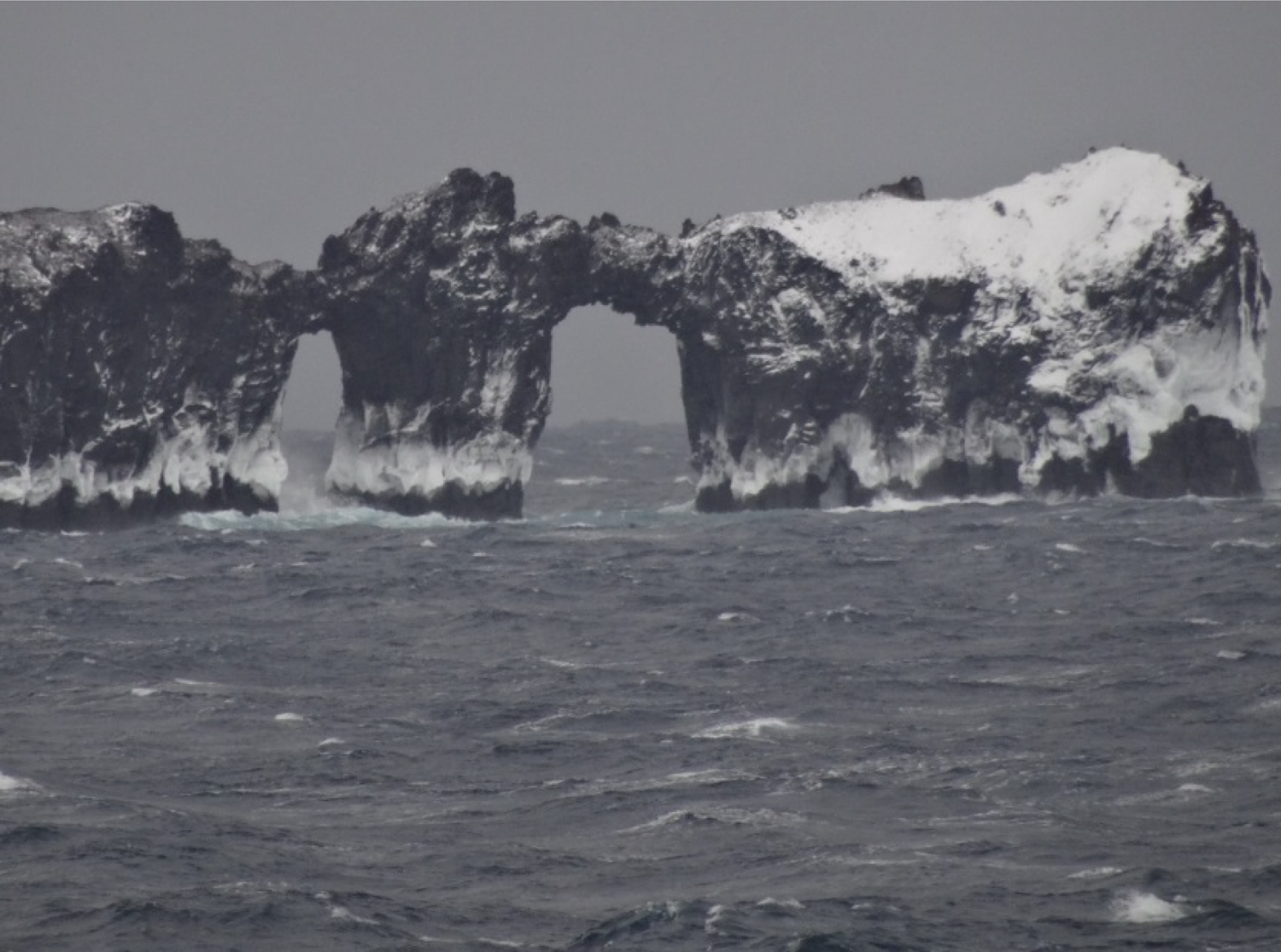
Fig. 9. Sea arches Kristensen Rock 2017. A smaller third opening is to right.
Davey shoal
The Possession Islands archipelago are the emergent high points of an elongated submarine plateau 16 km long by 3 km wide that is separated from the mainland by a > 250 m deep body of water that is used as a shipping lane by supply vessels and tourist ships (Fig. 1). This is informally known as the Davey Shoal named for F. J. Davey a New Zealand marine geophysicist.
Much of the shoal is less than 50 m deep, and satellite imagery shows tabular icebergs up to 1 km across can be grounded on it for several months. Most of these icebergs have likely calved from floating ice tongues in Mowbray Bay, 40 km to the SW.
Discovery and exploration 1841–1956
The Possession Islands have a long and interesting human history, and scientific observations have been part of this from the beginning.
The quest for South Magnetic Pole and the Transit of Venus
In 1837–39, three rival national expeditions from France (Dumont d’Urville 1837 to 1840), the United States (Charles Wilkes 1838 to 1842) and Great Britain (James Clark Ross 1839 to 1843) were sent to the Antarctic region to locate the position of the South Magnetic Pole.
Although setting out last, Ross’s expedition became the first to enter the vast Ross Sea embayment and see the Possession Islands. On 12 January 1841, Ross’s two ships HMS Erebus and HMS Terror approached within 2–3 nm of the northern island. A long boat from each ship set out to attempt a landing on the mainland but found the shoreline covered with ice with a heavy surf breaking. They then headed back to the islands and got into an eddy under the lee of the largest of the islands and landed on a beach of large loose stones and stranded masses of ice (Ross, Reference Ross1847, Vol 1 p. 188). The weather had deteriorated, and a recall flag on the Erebus was warning of the danger. A ceremony taking possession of the lands in the name of Queen Victoria was immediately proceeded with, the Union Jack flag raised, a celebratory sherry drunk and three hearty cheers given. They loaded their boats with geological specimens and penguins and returned to their ships only a short time before so thick a fog came on … that to have been a few minutes later would have rendered our return to the ships impossible (ibid, p. 190). This, the first landing south of the Antarctic Circle had lasted just 25 min (McCormick, Reference McCormick1884). The scene was captured in a sketch by J.E. Davis the second officer on HMS Terror who was a topographical painter for the navy (Fig. 10). This recognisably records the beach and cuspate foreland with Archer Peak behind and East Kristensen Rock in the distance on the right. His watercolour version of the scene is in the collection of the Scott Polar Research Institute. Davis also painted an accurate view of Possession Island from the northeast including Archer Peak, Dickson Pillar and both Kristensen Rocks (Ross ibid, facing p. 183).

Fig. 10. Landing on Possession Island 1841. (Ross, Reference Ross1847, Vol 1. facing p. 164).
Ross named the island Possession Island and charted its location as 71o 56’ S and 171o 7’ E, about 3 nm to the south of its actual location and only 1 nm north of Foyn Island. However, he was clearly referring to the largest and northernmost of the islands (ibid, p. 188, p. 190), which is Possession Island.
A storm then forced the ships away to the east, but they were able to return on 15 January sailing close to the southernmost islet of the archipelago which he named Possession Islet (now Heftye Island). The islands were seen again from the east as the ships sailed north out of the Ross Sea on 20 February 1841.
In these three different approaches to the islands, Ross saw the whole group and recorded they formed a chain of islets which extends about ten miles to the southward of Possession Island. It [the chain of islets] consists of eight dark-coloured rocks of small size and curious shapes: an arched perforation was observed in one of them [West Kristensen Rock], through which the mainland was seen; another was considered to resemble a ship’s capstan [possibly East Kristensen Rock] (ibid Vol 1, p. 194).
Following Ross’s 1841 discovery, 54 years would pass before the next expedition landed on Possession Island, although not without recommendations they be revisited to observe Transits of Venus in 1874 and 1882, or mine the rich bed of guano described by Ross.
In the late 1860s interest in the upcoming 1874 and 1882, Transits of Venus generated proposals for scientific exploration of the Southern Ocean and Antarctica. John Davis, the second officer on HMS Terror, suggested that a prime location for observations of the Transit of Venus would be at Coulman Island that he had seen in 1841, but if there was no harbour or a suitable landing site there, the expedition should return at once to Possession Island … and land the party with … huts, instruments and provisions for two years. The ships would return the following year to pick up the southern party and return to England (Davis, Reference Davis1869).
Joseph Hooker, who had sailed with Ross on HMS Erebus, was unimpressed with his former colleague’s proposal:
Possession Island, or rather Possession rock, is in a very inaccessible position. The chance of landing a well-equipped party upon it when reached and the prospect of its subsequent removal by ships, if landed on, is very small. In any case I feel little uncertainty as to what would be the fate of a party left there for the winter, and the prospect of their seeing the transit would be absolutely nil (Hooker, Reference Hooker1873).
A Transit of Venus expedition to Possession Island did not eventuate. However, the circum-Antarctic oceans were investigated as part of the lengthy Challenger Expedition (1872 to 1876). In 1893, Dr John Murray who had been on that expedition addressed a meeting of the RGS in London (27 November 1893) urging the renewal of Antarctic exploration as responsibility (now) rests on the geographers and representatives of science in this country (i.e. the United Kingdom) (Murray, Reference Murray1894).
“Heroic Era” expeditions 1895–1917
Two years after the RGS meeting, the Union Jack was once again hoisted on Possession Island, although not by a British or scientific expedition. The Norwegian, Henryk Bull had secured funding and a ship (the Antarctic) from Svend Foyn, a wealthy whaling magnate, to investigate commercial possibilities in the Ross Sea, in particular around the Possession Islands where Ross had reported the presence of whales. The Antarctic was close to Possession Island at 8 pm on 19 January 1895 and Bull, Captain Kristensen, Carsten Borchgrevink the expedition’s volunteer amateur natural historian, and four other crew members rowed ashore in calm, ice-free conditions (Kristensen, Reference Kristensen and Chaplin1895). They found the island and its penguins much as Ross had described them in 1841. The party spent about 4 h ashore, observing the penguins and skua “gulls,” and collecting rocks, moss, lichen, seaweed, guano and penguins that were taken back to the ship. Kristensen reported we put up a mark near where we landed, consisting of a pole, well supported by big stones, to which we nailed a box containing my card (Melbourne Age, 7 September 1895, p. 9).
This Antarctic Message Pole has been recorded as Historic Monument #65 in the Antarctic Treaty List of Historic Sites and Monuments, although it is incorrectly listed as being on Foyn Island. This humble rock pile (and wooden post if it still exists) is significant being the oldest physical structure erected by humans in the Ross Dependency, and the first structure built south of the Antarctic Circle. It was used by subsequent explorers as a sort of post office.
Bull also obtained the first photograph of Possession Island, a view at sea from the north (Strand Magazine March 1897, p. 348). Despite being correctly labelled in 1897, this image is shown on the Wikipedia page for Foyn Island showing again the continuing misnaming of these islands. Borchgrevink was a competent artist, and he made many sketches of the islands that were published in Australian newspapers (Leader, 30 March 1895, p. 6; Australian Town and Country Journal 11 May 1895, p. 21; Sydney Mail 18 May 1895, p. 1015). Figure 11 is an example from the Strand Magazine (March 1897, p. 351) showing from left to right Possession Island, Kristensen Rocks, Favreau Pillar and Foyn Island.

Fig. 11. Possession Island sketched by C.E Borchgrevink, 1895. The Strand Magazine, p.351 March Reference Borchgrevink1897.
Four years later in February 1900, Borchgrevink returned to Possession Island in the Southern Cross leading the British Antarctic Expedition (1898 to 1900). They had wintered nearby at Ridley Beach, and in March, July and November of 1899 Borchgrevink had made three unsuccessful attempts to sledge over the sea ice to Possession Island (Crawford, Reference Crawford1998).
The 3 February 1900 landing included Captain Jensen of the Southern Cross, most of the winter-over party including William Colbeck, and some of the ship’s crew. They landed on the western point of the island where Bull and Borchgrevink had landed in 1895. Colbeck’s description of the landing contained familiar details:
Jensen called me at 5 a.m. [There was] a strong SE wind, moderate seas and snowing heavily….there was a real risk in landing the instruments in such a sea…at 6 oc[lock] we had coffee and then the staff and Mr B[orchgrevink] landed. We first visited the pole [and] I then wrote a note …I counted 7 islands, 2 big ones and the others merely islets or perpendicular rocks…one of the larger ones had three holes thro[ugh]’ which heavy seas were dashing; bad lookout for a small boat in that quarter (Colbeck, Reference Colbeck1900).
During the hour spent ashore, photographs were taken by Bernacchi who had time to walk to the interior of the island reaching near the summit of Peak Archer. Seven photographs were published in Borchgrevink’s expedition account (Borchgrevink, Reference Borchgrevink1901, p. 255–261), showing the island was under a heavy snow cover at the time. A message was left in the tin on Bull’s message post and a collection made of rocks, vegetation and several young skuas. Bernacchi observed that Possession Island was much better adapted in every way as a winter quarter than Cape Adare [and] there is much better shelter (Bernacchi, Reference Bernacchi1901, p. 236).
On 10 January 1902, the SY Discovery (Capt. R.F. Scott) passed 15 nm to the east of the islands on its way to establishing winter quarters on Ross Island. It had been planned to leave tin cylinders at pre-arranged places to give a record of progress as they made their way south into the Ross Sea. The weather and sea ice conditions prevented any landing at the Possession Island. The following year on 8 January 1903, the Relief Expedition ship Morning, captained by William Colbeck arrived off the Possession Island at 4 p.m., hoping to find information on the Discovery’s intentions in the “post office” (Scott, Reference Scott1905, Vol 2, p. 158).
This was the fourth landing on Possession Island (Fig. 12), and it lasted less than two hours. Morrison who took photographs reported:
Walked a mile to the post office a post stuck on a hill. I got to the post, took a photo and broke open the letter box before the No.1 [England] arrived. He had been fatigued with the many difficulties of the landing, so he took the shore road instead of climbing the hill… (Morrison, Reference Morrison1903).

Fig. 12. Morrison beside message post left by the Antarctic in 1895. Licensed with permission of University of Cambridge, Scott Polar Research Institute. Reference P2007/24/37.
They found no message from Discovery the year before, so they took Borchgrevink’s 1900 note and left their own record on the conspicuous and well-chosen mark (Colbeck, Reference Colbeck1903). A geological collection was made from nearby cliffs and the doctor stole two young penguins (Morrison, Reference Morrison1903).
Morrison’s description of the post being “stuck on a hill” does not tally with his photographs, and it is in fact on an old beach ridge a few 10 s of metres from the shore.
When Scott’s National Antarctic Expedition departed Ross Island in February 1904, they ran into a storm and the Discovery’s rudder was damaged (Yelverton, Reference Yelverton2000) rendering her difficult to control so that when they passed through the Possession Islands on 24 February 1904 no landing was attempted. However, Scott (Reference Scott1905) did note the islands were a curious and interesting group [with] two huge arches’. Dr Edward Wilson, the expedition’s doctor and zoologist, was more impressed recording a glorious view ahead of the very fantastic Possession Islands. There are nine of them, all sorts of shapes….all of the forenoon and afternoon I spent in sketching them (Savours, Reference Savours1966). He produced a charming watercolour of the Discovery passing the archipelago (now in the collection of the Dundee Heritage Trust).
During the British Antarctic Expedition (1910–13), the Terra Nova passed the islands about 12–13 February 1911 prior to the landing the Northern Party at Cape Adare. No landing was made on the islands, although geologist R. Priestley observed the wave worn appearance of the islands [with] one having a very perfect natural arch (Priestley, Reference Priestley1923).
The last Heroic Era sighting of the islands was from the Aurora (Capt. J.R. Stenhouse) as the ship drifted past 45 nm to the east on 6 August 1915. The islands were seen lying under the stupendous bluff of C[ape] Downshire (Stenhouse, Reference Stenhouse1915). It is highly unlikely they could have been seen from such a distance, and the sun would only have been above the horizon for 4 h at that time and latitude. Perhaps the sighting was a mirage effect.
The 1920s–40s expeditions of Larsen and Byrd
After 1917 exploration and science in the Ross Sea area, largely ceased for 40 years until the late 1950s. However, some ships passed close to and observed the islands as part of whaling activities in the 1920s, and they may have been seen from icebreakers of the US Navy Operation Windmill in 1948.
In the early 1920s, New Zealand granted a 5-year licence for whaling activities in the Ross Dependency to a Norwegian company. The first season was in the 1923–24 summer with the factory ship Sir James Clark Ross and five chasers Star 1 to 5. The Norwegian Carl Anton Larsen was the manager, and the object of this first season was to seek suitable bases for a whaling fleet. Captain George Hooper, the newly appointed New Zealand Government Administrator of the Ross Dependency, accompanied the expedition, along with a team of scientists.
On 30 January 1924, Star 1 sailed along the Victoria Land coast at the Possession Islands a southerly gale began to blow, and navigation through the great bergs and drifting floes became extremely difficult and dangerous, making a landing impossible (Barr & Watt, Reference Barr and Watt2005; Villiers, Reference Villiers1933, p. 59). They made observations from the ship, and Captain Hooper took several photographs that are now in Museum of New Zealand Te Papa Tongarewa. On a hill above a penguin colony they saw something high placed on end (Kaldager, Reference Kadalgar1925). This may have been Bull’s Antarctic message post, but the description of it “on a hill” is at odds with its actual location near the shore.
The following season the whaling fleet returned, and between 1 December 1924 and 22 January 1925, the factory ship operated between Coulman Island and Possession Islands. The only record of islands being seen was on 24 December 1925 when one was seen and named for C.A. Larsen who had died 2 weeks before (Tønnessen & Johnsen, Reference Tønnessen and Johnsen1982). It is not known which island this might have been. The Possession Islands were not visited again until after World War 2.
The US Antarctic expedition Operation High Jump (1946–1947) was led by Admiral R.E. Byrd. Although most of the Antarctic coastline was photographed from the air, none was undertaken in the Possession Islands area. The following year Operation Windmill returned to Antarctica to secure ground control for the previous season’s aerial photography. Once again, the Possession Islands were not included in this work. However, two of the expedition’s icebreakers, USS Burton Island and USS Edisto, did sail south past the islands on 27 January 1948 on their way from the Balleny Islands to McMurdo Sound. It is not known whether any observations were recorded.
Deep Freeze 1 and IGY
The modern era of scientific exploration of Antarctica started with the International Geophysical Year (IGY) that ran from July 1957 to June 1958. Planning for this began in the mid-1950s, with the US contribution, Operation Deep Freeze, commencing in the summer of 1955–1956. As the IGY science in the Ross Dependency area was to be supported by air transport based in New Zealand, an important consideration was to establish an emergency runway for wheeled aircraft somewhere on the North Victoria Land coast that could double as a favourable location for a scientific station (Dater, Reference Dater1965). During these reconnaissance activities, the Possession Islands were visited and mapping activities resulted in them being more accurately charted (United States Naval Oceanographic Office, 1955).
Operation Deep Freeze brought a fleet of modern icebreakers to the Ross Sea including the Wind Class Eastwind, Westwind, Edisto, and Staten Island, and the much larger Glacier. These vessels allowed much more extensive work to be undertaken including oceanography, geological sampling, sea ice studies and hydrographic data collection. They were equipped with helicopters (later turbine-powered) making landings much easier.
In February 1956, the USS Edisto was tasked with investigating sites for the emergency airfield and research station. They visited Ridley Beach at Cape Adare, Cape Hallett, Cape Jones and Possession Island. Heavy surf at Ridley Beach on 7 February allowed only a brief landing there. After a motor whale-boat broached, the Edisto headed south towards Cape Hallett, charting the coastline which they found was not accurately located (Fig. 13). Conditions at Possession Island also prevented a landing there, and they continued south to Cape Hallett where conditions were more favourable. However, the IGY representative considered Possession Island was the most suitable location for a meteorological station indeed he was most emphatic in his recommendation that a station in this locality is necessary for the success of forecasting and meteorological mapping during the IGY (US National Committee – IGY Antarctic Operations Report, No. 5, February 17, 1956).

Fig. 13. Estimated coastline with Station Plots. US Navy Hydrographic Office Report on Operation Deep Freeze 1, October 1956(a). H.O. 16331-1 P. 20.
Edisto returned to the Possession Islands as on the way down [from Cape Adare], the eyes of both the IGY representative and civil engineers had been attracted to Foyn, formerly Svend Foyn, one of the Possession Islands (Dater, Reference Dater1965). Here again, Possession Island and Foyn Island had been confused as Foyn Island has no flat land suitable for an airfield.
An oceanographic sampling station (ED7) was occupied off the southwest corner of Possession Island (Fig. 14) referring to it being in an unprotected location off the west side of Svend Foyn [sic] Island (United States Navy, 1956a). Late on the evening of 11 February, a party went ashore in an LCVP (Landing Craft Vehicle Personnel). However, it was caught by a large swell when approaching the beach, broached and had to be abandoned. The wreckage is still there, high on the beach at Possession Island (Fig. 3). Before the seven men could be rescued, a storm with 60-knot winds trapped them ashore for the night (United States Navy, 1956b; Harrowfield, Reference Harrowfield2021), and they became the first party to spend a night on the island. The next day the shore party was brought off by rubber boat [and] Edisto’s commanding officer observed a rocky beach, strong currents and drifting ice which made Foyn [sic] Island “somewhat inaccessible” (Dater, Reference Dater1965, p.24).

Fig. 14. Box and whisker plot of Possession Island monthly temperature calculated from 3 hly observations 1993–2021 (max, min, 25%ile 75%ile, median, mean line).
The possibility of Possession Island as a site for an airstrip was sensibly dropped, and Cape Hallett was settled on as the most favourable location for a station, and the joint US/New Zealand Hallett Station was subsequently built there.
The IGY was originally intended to last for just a year but was such a success that the countries involved decided to maintain the temporary stations that had been built as permanent bases for scientific exploration of the continent. The IGY had brought modern icebreakers and aircraft to Antarctica and with later developments in long distance international flights and advances in helicopter technology scientists were able to access the whole continent. The Possession Islands just 58 km northeast of Hallett Station were ideally situated for more detailed scientific examination, but while some work was done, they were never a focus of scientific endeavour.
Science at the Possession Islands
Natural history and science observations were made on the first landing in 1841 and on most subsequent landings until the mid-1950s. With the IGY of 1957/1958, the era of Antarctic science exploration began, and the islands have been visited, and more science has been carried out and published. While papers have been published that include information on the islands, today, more than 60 years after the IGY no scientific paper has been published that includes in its title the words “Possession Island” or “Foyn Island” (Google Scholar searched 29/6/2022).
Observations and collections by early explorers
The Ross 1839 to 1843 expedition’s primary goal was to locate the South Magnetic Pole, and magnetic observers were the main scientists. Nonetheless, extensive natural history collections were also made, including rocks, and marine and terrestrial animal and plant life. However, on return to Britain the biological material was in such bad condition that much was lost. Some has been retained in the Natural History Museum, London (Bradford-Grieve & Fenwick, Reference Bradford-Grieve and Fenwick2001), with Robert McCormick’s zoological specimens being among the surviving materials. McCormack was surgeon on HMS Erebus and most interested in birds which he shot at every opportunity (Stone, Reference Stone2020). He also made rock collections and at Possession Island collected 10 samples that he stuffed in his haversack along with an old penguin he had knocked down with his geological hammer (ibid). McCormick’s rocks were identified as volcanic and of basaltic origin but created little interest as discussed by Stone (Reference Stone2020).
McCormick was impressed with a notable species of “lestris” or skua gull on the island. He saw this large predacious and aggressive bird on other occasions and after he was able to shoot one decided it was a new species which was named Megalestris maccormicki after McCormick. In the early 20th century, it was reclassified as Catharacta maccormicki and for a long time was commonly known as McCormick’s skua. It is now the South Polar Skua and has again been reclassified as Stercorarius maccormicki.
Henryk Bull considered his expedition of 1894/95 made poor additions to natural science due to the absence on board of anyone of fair scientific attainments (Bull, Reference Bull1896, p. 228). Hardly, a ringing endorsement of the expedition’s self-appointed natural scientist Carsten Borchgrevink. The latter reported finding lichen in sheltered nooks on the island [and] constituted the most interesting result of the day, as it upset previous theory of botanists, that the rigour of the Antarctic was fatal to all vegetable life (Bull, Reference Bull1896, p. 173). The discovery of lichen has not been corroborated by recent scientists (P. Broady, personal communication, August 31, 2021). Borchgrevink also collected a large sample of guano and more rocks. Some of these were given to Professor T.W. Edgeworth David of the University of Sydney who later went to Antarctica with Ernest Shackleton in 1907. Others were described by J.J.H. Teall in Appendix II (Bull, Reference Bull1896), and the story of all these samples has been told by Faithfull & Durant (Reference Faithfull and Durant2001). Overall, these rock samples confirmed McCormick’s findings of the volcanic origins of Possession Island and added little to geological understanding of Antarctica.
Borchgrevink’s 1899–1900 expedition was better equipped for scientific observations, but the zoologist Nicolai Hanson sadly died during the winter. More rocks were collected on Possession Island but were not different from those collected in 1895 (Borchgrevink, Reference Borchgrevink1901). The samples that reached the geologist at the British Museum of Natural History were not well received with Prior (Reference Prior1902) noting for the most part [they] had no locality-labels attached to them and are accompanied by no lists or geological details as to their mode of occurrence and mutual association in the field.
Specimens of “vegetation” were again collected with Colbeck (Reference Colbeck1900) noting the moss here is the same as we found at Cape Adare (the green moss), and Borchgrevink described the finding of an abundance of moss, of three different kinds…(Newnes, Reference Newnes1899). However, on this occasion apparently no lichens were observed. Some of the inconsistencies in these reports of lichens and moss may be due to the observers not being trained botanists, but notwithstanding whether or not moss and lichen occur the physicist Bernacchi (Reference Bernacchi1901) made the pertinent observation that the appalling poverty of flora of the Antarctic regions stands out in glaring light when compared to that of the Arctic regions. The botanical samples were passed on to Sir George Newnes the financial backer of the expedition, who then presented them to the British Natural Museum. However, they were found to be poorly documented and badly preserved (Gepp, Reference Gepp1902).
The last Heroic Era visit by the Morning did not result in any significant observations with Morrison remarking “Possession Island is mostly penguins and primaeval cinders and about as interesting as a gravel pit” (Ferrar, Reference Ferrar1907; Morrison, Reference Morrison1903).
Modern scientific endeavours and monitoring
Although the IGY ushered in the era of intensive scientific exploration of Antarctica, and for some years the Possession Islands were close to the research station at Cape Hallett, they have not received the level of attention that might have been expected. It was not until November 1964 that scientists were flown from the station to the islands, and shortly after in January 1965 scientists from USCGC Glacier were flown ashore for a few hours. The research station closed in 1973, and it was not until January 1983 that Glacier again flew scientists ashore for a brief visit. Since then, there has been a visit by the USCGC Polar Star to install an automatic weather station (AWS) in December 1992, and there have been three cruises (to Possession Island) by the New Zealand ice-strengthened marine research vessel RV Tangaroa in 2001 and 2004.
Temperature monitoring
An AWS operated by the University of Wisconsin-Madison was installed on Possession Island on 30 December 1992. It was delivered by helicopter from the icebreaker USCGC Polar Star, the last visit to the island by a US vessel. The AWS is a simple “dog house” design with temperature and pressure sensors and solar panels mounted on kennel-like box. It is located at 71o53’27.6”S, 171o12’36.00’E and 30 m above sea level, which is mid-way along the cliffs on the east side of the island. It transmits data to the Antarctic Meteorological Research Data Centre Repository (AMRDCR, 2000) every 10 min. Quality controlled data are available for the period 30 December 1992 to 31 March 2021 with 89.5% data coverage. The AWS has not been revisited since it was installed and remarkably is still transmitting data (max/min/mean temperatures and max/min mean pressures) after nearly 30 years. The batteries have been weak since 2011, and in the dark winter months the AWS ceases transmitting data.
There is a typical annual pattern (Fig. 14) with winter lasting 6 months (April–September), and the coldest month of August occurring after the sun has returned. Average winter temperature is −18.3oC and the coldest temperature was −36.2oC recorded 22 July 2004. Spring (October–November) sees temperatures rising and by the time the sun is permanently above the horizon, and temperatures above freezing are occurring. Average spring temperature is −8.9oC with ∼6% of observations above freezing. Summer (December–January) has an average temperature of 0.9oC with above zero temperatures occurring 54% of the time. Maximum recorded temperature was 10.80C on 2 January 2014. Autumn (February–March) sees a decline in temperature, has an average temperature of −5.4oC and is below freezing 97% of the time.
Annual mean temperature is −12oC, calculated from the years 1993–1995 and 2001–2009 being years with more than 95% data coverage. The years 1996–2000 have 9% missing data, mostly in spring and summer, while the years from 2010 have 20% missing data mostly in winter. Thus, the full annual series cannot be used to estimate whether there has been a warming or cooling trend.
Topographic and hydrographic mapping
Although the general location of the Possession Islands archipelago has been known since 1841, the topography of the islands has not been surveyed and it is only since the late 1960s that they have been accurately shown on hydrographic charts. Recent satellite altimetry has at last provided detailed topographic data.
It was not until the IGY and later years that reconnaissance topographic mapping of Antarctica began in earnest. This was spearheaded by the US Navy trimetrogon aerial photography missions supported by ground survey of widely scattered photocontrol points. Aerial photography of the Possession Islands was captured in January 1958 (run #s TMA 355, TMA 358, TMA 366, and TMA 369) and November 1961 (TMA 866) and is available at the USGS Earth Explorer website (https://earthexplorer.usgs.gov/). Flown at 15,000 ft to 25,000 ft, the vertical images were at 1:30,000 and 1:50,000 scales. Ground control points were obtained by New Zealand surveyor Malcolm Ford on Possession Island (Archer Peak) on 21 January 1965 and Foyn Island (St Marie Peak) on 22 January 1965. The map sheet Cape Adare (Sheet SR 59-60/13) was published in 1968 at 1:250,000 scale by both the USGS (Fig. 1) and New Zealand Lands and Survey Department. Given the two organisations shared data, the resulting maps are very similar.
To date, these are the only published topographic maps of the Possession Islands. The Land Information New Zealand on-line gazetteer has base maps of Possession Island and Foyn Island that show they have undertaken more detailed mapping that includes contour data, but these have not been published.
USGS undertook further aerial photography in December 1983 obtaining low-level vertical imagery of the penguin nesting areas on both Possession and Foyn Islands. Since 2010, relatively high-resolution Google Earth satellite imagery has become available for the archipelago with Possession Island covered by imagery from 4 February 2010, 15 November 2011, 2 March 2017 and 18 November 2017. Foyn Island is covered by imagery from 4 February 2010, 15 November 2011 and 3 February 2017. Since 2008, the islands have been captured many times by satellite imagery with 85 scenes available from the Maxar satellite constellation (see https://discover.digitalglobe.com), and many scenes also available at https://eos.com/landviewer. Freely available low-resolution imagery from these sites allows mapping of sea ice cover, icebergs and snow cover.
The US National Science Foundation Office of Polar Programs has developed the Reference Elevation Model of Antarctica (REMA), a high-resolution (8 m) digital surface model (DSM) of the continent using data from the Maxar satellite constellation. The data were acquired 2009–2017, and the DSM was released in 2019. The DSM covers both Possession and Foyn Islands as shown in Figure 15a, b. With the availability of satellite imagery and a DSM, more detailed assessment of the islands’ geomorphology is now possible.

Fig. 15 a,b: DEMs of Possession Island (left) and Foyn Island (right) (Colour ramp 0–120 m elevation, 5 m intervals, light blue–mid-orange; 120–200 m elevation, 10 m intervals, mid-orange–red).
The 1968 USGS topographic map compiled known bathymetric soundings at that time from which it was apparent the islands probably formed the high parts of a largely submerged shoal area (“Davey Shoal”), less than 100 m deep, and separated from the Adare Peninsula by a > 200 m deep channel, with depths >300 m occurring just a few kilometres east of the islands. In recent years, New Zealand has taken responsibility for hydrographic surveying and charting in the Ross Sea region, and an early focus of this programme was to accurately chart shipping lanes at the NW entrance to the Ross Sea along the North Victoria Land coastline from Cape Adare to Possession Islands and Cape Hallett (Blick, Reference Blick1999). The work was carried out under contract to New Zealand’s National Institute of Water and the Atmosphere (NIWA) using their ice-strengthened deep ocean research vessel the RV Tangaroa. The first hydrographic survey was undertaken in January–February 2001 resulting in the publication in 2003 of Chart NZ 14907 (INT 9007) Possession Islands (scale 1:60,000). NIWA collected more data in February 2004, and the chart was updated in 2006.
As part of these hydrographic surveys, NIWA twice attempted to establish a temporary primary tide station on Possession Island. On 11 February 2001, Tangaroa landed four surveyors to install benchmarks and the tide station (Fig. 16). They chose a site under Archer Peak on the western side of Possession Island and camped for two nights while installing the station. About 5 days of data were obtained, but strong winds resulted in sea ice damaging the station, and it was dismantled between 20 and 22 February (NIWA, 2001a, 2001b; 2004a, 2004b). The survey party had spent a total of two nights on the island, becoming the island’s longest-term visitors. Other science parties also worked on the island and a total 22 people were on the island during this period, the largest science party to have visited the island (NIWA 2001a, 2004a).

Fig. 16. Surveyors record position of a temporary tide gauge. Courtesy NIWA. Reference W2pKsHvR.
The second attempt to install a tide station occurred in February 2004. Five surveyors were landed at the 2001 site on 4 February, and the station was installed and data collected for 25 h until the end of 5 February. Storm conditions then set in, and the party had to shelter in tents on the island. They were able to inspect the tide station on 8 February and found it had been destroyed. They were taken off the island on the morning of 9 February. The 5 days ashore by the surveyors is the longest continuous visit by people to Possession Island. Tangaroa returned to Possession Island on 25 February to retrieve the sea bed tide gauge but were unsuccessful, and it was declared lost (NIWA, 2004a).
Seasonal sea ice cover
Analysis of 85 low-resolution satellite images (at https://discover.digitalglobe.com/) covering daylight months of September to March 2008–2021 shows that the islands are likely to be beset by fast ice through the winter from at least May to August. In September–October, the ice edge retreats southwards past the islands, initially more quickly in the channel between the islands and McCormick Island. From November to December, dense pack ice surrounds the islands, and this dwindles through January with an open water season during February and March. It is during these months that waves break directly on the shoreline to form the beaches.
Snow, ice and hydrological features
Snow can temporarily cover the islands to sea level after storms at any time of year, but permanent snow only occurs on Possession and Foyn Islands, the other islets and rocks being too small and/or steep to allow permanent snow accumulation. There are no obvious ice cap or glacier flow features, associated with any permanent snowbanks, but it is considered likely that glacier ice does occur at depth in the larger snowbanks particularly on Foyn Island.
In September, the main islands have many snowbanks remaining from winter that melt back over the spring and summer months. Available aerial photography and satellite imagery show highly varying extents with minimum area occurring in December 1958, November 2011 and January 2021 when there was ∼89 ha (29%) snow coverage on Possession Island mostly between 30 m and 55 m elevation. On Foyn Island in November 2011 and January 2021, the minimum extent was ∼60 ha (33%) coverage, mostly between 20 m and 125 m elevation.
There is no evidence for significant change in minimum snow extent on Possession Island between 1958 and 2021. However, on Foyn Island, there was a noticeable change between December 1983 and February 2010 as described below.
There are many small streams on Possession Island that carry snowmelt runoff to the sea during summer months. A small southern catchment of ∼20 ha drains seasonal snowbanks around Archer Peak and southern parts of the central valley and discharges at the eastern end of the south beach. A larger catchment of ∼25 ha takes snowmelt from the main eastern snow/ice area and the central ridge, and its stream flows north to the sea at the eastern end of the main north beach. The third catchment area and channel network carries snowmelt west from the central ridge across the cuspate foreland. It covers ∼30 ha and has a complex network of shallow anastomosing channels. These flow into seven interconnected shallow intermittent lagoons between the beach ridge landforms. Altogether these cover ∼3.5 ha. There is no obvious single discharge point to the sea rather there are numerous small outlets onto the southwest beach of the cuspate foreland. On Foyn Island, there is only one small snowmelt drainage catchment of ∼3 ha that carries runoff across the raised shore platform to the sea.
Geology
Rock collections by early explorers had shown the islands comprised basaltic volcanic rocks, and spectacular columnar jointed lavas on the east side of Possession Island and in Favreau and Dickson Pillars (Fig. 17) drew comparisons with Fingal’s Cave in Scotland (McCormick, Reference McCormick1884). However, it was not until late 1964 that geologists were able to make more than fleeting observations of the archipelago’s rocks.

Fig. 17. Dickson Pillar and east side of Possession Island with columnar basalt. Courtesy NIWA.
Warren Hamilton, a USGS geologist, was flown by helicopter from Hallett Station and made the first close observations of the volcanic systems that had originally formed the islands. This, the first helicopter landing on the islands, occurred on 8 November 1964, and the results published in a USGS Professional Paper (Hamilton, Reference Hamilton1972) remain the first and only detailed account of any branch of science of the Possession Islands. Hamilton landed on both Possession and Foyn Islands, collected samples, and did photo-geological examinations of Heftye and Bull Islands. His key interpretation was the volcanism had occurred between 25 and 6.13 million years ago beneath an already existing Antarctic Ice Sheet. Regionally, Hamilton identified that the Possession Islands were related to extensive piles of volcanic rocks along coastal North Victoria Land including the Adare Peninsula, Daniell Peninsula, Hallett Peninsula, and Coulman Island, which he called the Hallett Volcanic Province. More recent work includes the Hallett Volcanic province rocks in the McMurdo Volcanic Group. Unfortunately, Hamilton’s extensive rock collection was subsequently discarded (Prof J. Smellie, personal communication, 5 July 2022).
Two months after Hamilton’s field work, the islands were visited again when a party of New Zealand and US scientists were landed by helicopter from the US Navy icebreaker Glacier. The landings occurred on 21 January 1965 on Possession Island and 22 January on Foyn Island. B. Waterhouse of the New Zealand Geological Survey was in the party. The islands were described as a combination of quaint black rocks and pillars amongst ice floes [and] most impressive (Quartermain, Reference Quartermain1965). The party found a cairn thought to date back to 1900, most likely a reference to the Antarctic Message Post, and they left a record in it (ibid). This is the last time the site is known to have been visited.
Hallett Station was closed in 1973 as the reliability of intercontinental flights meant an emergency landing site was no longer needed. The Possession Islands thus lost their proximity to close helicopter support before it had been much visited and scientific examination reverted to being from passing ships.
In January 1983, USCGC Glacier returned to the islands with a party of US and New Zealand earth scientists. Wesley Le Masurier, William MacIntosh and Anne Wright collected samples on Possession and Foyn Islands on 15 January 1983, and these are now stored at the Polar Rock Repository and the Ohio State University. Their preliminary observations were published by Le Masurier et al. (Reference LeMasurier, Ellerman, MacIntosh and Wright1983) who proposed the rocks could have been formed by volcanism that was at least in part subaerial and not beneath ice. Kyle (Reference Kyle1990) published geochemical analyses of these samples and noted polished pebbles in some of the volcanic deposits suggested eruption in association with a beach environment.
These 1983 samples were again used by Panter et al. (Reference Panter, Castillo, Krans, Deering, McIntosh, Valley and Blusztajn2015) for a study of sea floor basalts of the NW Ross Sea. They determined the Possession Island samples had formed 0.16 and 1.42 million years ago, and the Foyn Island samples were 0.33 and 0.24 million years old.
Since 1983, no earth scientists have visited the islands. Despite some advances they remain largely unknown and lack even a basic geological map or logged descriptions of rock sequences that are well exposed in reasonably accessible gullies in the cliffs.
Geophysics
Since the 1970s marine (magnetic, gravity and seismic), geophysical data have been obtained from ships operating in the Ross Sea including some in the vicinity of the islands and, more recently, an aeromagnetic survey with one line crossing the islands (Damaske, Läufer, Goldmann, Möller, & Lisker, Reference Damaske, Läufer, Goldmann, Möller, Lisker, Cooper and Raymond2007). An extensive literature on this work has evolved.
According to Davey et al. (Reference Davey, Granot, Cande, Stock, Selvans and Ferraccioli2016), their study suggests “that the onset of sea floor spreading in oceanic crust that formed the Adare Basin in the north and rupture of adjacent continental crust forming the Northern Basin has apparently occurred at the same time…and that little extension and thinning of continental crust occurred before it ruptured, and the new oceanic crust emplaced.” The extension forming this basin occurred from 43 Ma to 26 Ma; however, minor, much younger rifting (Granot & Dyment, Reference Granot and Dyment2018) may be associated with the volcanic activity forming the islands.
Coastal geomorphology
During the January 1983 visit of USCGC Glacier, observations of coastal geomorphology were undertaken by New Zealand earth scientists Mark Mabin and Murray Gregory. Gregory, a marine geologist surveyed over 2,200 m of shoreline finding the islands’ beaches had accumulated small quantities of floating lumber and metal pollutants thought to have come from Hallett Station and the slow break-up of the wrecked LCVP (Gregory et al., Reference Gregory, Kirk and Mabin1984b). He also conducted echo sounding from a zodiac to investigate shallow nearshore erosion platforms off Possession and Foyn Islands and Favreau Pillar (Fig. 8) (Gregory & Kirk, Reference Gregory, Kirk and Hatherton1990). The platforms were up to 200 m across and around 10 m depth locally veneered with rounded boulders up to 1 m diameter. Sea conditions allowed the zodiac to be taken through the large arch at West Kristensen Rock (Fig. 9) at 2 am and well out of sight of the icebreaker.
Mabin took uncontrolled low-level hand-held vertical aerial photography from the helicopter for mapping and surveyed the active beaches, cuspate foreland, and raised shore platform landforms on Possession and Foyn Islands. The foreland (Fig. 4) is one of several such features along the Victoria Land coast with other examples at Ridley Beach Cape Adare, Seabee Hook Cape Hallett, Edmundson Point, Franklin Island, Beaufort Island and Cape Bird on Ross Island. The suites of beach ridges in these forelands contain a record post-LGM isostatic rebound and recent environmental changes along the western Ross Sea coastline.
Shoreline types were reported in Gregory, Kirk, & Mabin (Reference Gregory, Kirk and Mabin1984a), and more detailed mapping of these has been possible with access to the high-resolution satellite imagery described above. Shore types are summarised in Table 1.
Vertical cliffs 20 m to 50 m high are the most common shore type and typically have a small ramp of seasonal ice-cemented debris at the base. They occur on the eastern and southern sides of the Possession and Foyn Islands. The steep cliffs are higher, up to 100 m on Possession Island and 200 m on Foyn Island. They are mantled with scree deposits indicating active slope erosion (Fig. 18).

Fig. 18. Talus cones on the back of a beach at Foyn Island. 2020.
On Possession Island, steep cliffs in the southwest corner supply cobbles and boulders to the foreland beaches to the north and also to south beach to the east. On Foyn Island, the main area of steep cliff has a beach at its base. This protects the cliff from wave erosion, and although there is extensive scree development it is no longer directly supplying sediment to the beach (Figs. 18 and 19).
A small area of low rocky shoreline is mapped on the west side of Foyn Island (in the centre of Fig. 6). This irregular low relief area is between 10 m and 30 m elevation and has a thin layer of penguin nesting gravels over bedrock outcrops. We interpret this as an area of raised shore platforms, and wave/sea ice planed features are particularly well developed at between 10 m and 12 m elevation.
Beaches occur along the relatively sheltered western sides of Possession, and Foyn Islands are important for Adélie penguin breeding as they provide relatively easy access to the colony areas behind, particularly on Possession Island. They are typical Antarctic boulder beaches with steep profiles and extensive ice cores until the ice foot melts out in late summer. We noted several storm berms across the 20 m to 45 m wide beaches on the Possession Island, and there was a prominent 1–2-m-high erosion scarp at the landward side. At Foyn Island, the active beach is ∼20 m wide (Fig. 19) and lacks the storm berms and erosion scarp. In the 1958 and 1961 US Navy aerial photographs, the active beach was ∼50 m wide but by 2010 the inner 30 m had become stable enough to be extensively colonised by penguins.

Fig. 19. Boulder beach along southwest shoreline Foyn Island.
Environmental change
The islands’ landforms show some evidence of environmental changes, although there is little sign of them being covered by expanded North Victoria Land glaciers during the Last Glacial Maximum (LGM) as their topography shows no obvious evidence of glacial erosion or deposition, and glacial erratics have not been reported (Hamilton, Reference Hamilton1972). Halberstadt, Simkins, Greenwoord, & Anderson (Reference Halberstadt, Simkins, Greenwoord and Anderson2016) review reconstructions of the extent of grounded ice in the Ross Embayment during LGM and show three different models with two having the grounding line near Coulman Island over 170 km south of the Possession Islands and one with the grounding line some 50 km north of the islands. Investigation of the glacial landforms and geology could provide important constraints on LGM reconstructions in this part of the Ross Embayment.
The cuspate foreland beach ridges on Possession Island and the raised shore platforms on Foyn Island suggest that a few metres of isostatic rebound has occurred here since retreat of the LGM grounded ice in the Ross Embayment. The modest amount of rebound implies there may have been no great thickness of ice cover during the LGM (Colhoun, Mabin, Adamson, & Kirk, Reference Colhoun, Mabin, Adamson and Kirk1992).
The beach ridge landforms suite also suggests more recent environmental changes. The ridges comprise well-rounded clasts transported less than a kilometre from the eroding cliffs below Archer Peak. This rounding suggests the cobbles have been exposed to high wave energy for a considerable length of time. At present, the open water season here lasts just 2 months. Thus, it is likely that at some stage in the past, there has been a period of warmer conditions with a longer sea ice-free season. This may be further evidence for the occurrence of the Medieval Climate Anomaly along the Western Ross Sea coastline (Koch et al., Reference Koch, Hall, de Bruyn, Hoeizel, Baroni and Salvatore2019; Lüning, Galka & Vahrenholt, Reference Lüning, Galka and Vahrenholt2019).
More obvious evidence for very recent environmental change occurs in a permanent snowbank/glacier on the southern end of Foyn Island. This covers ∼25 ha and has debris bands suggestive of actively flowing glacial ice formed in the SW lee of ridge. Its highest parts are 75 m elevation, and it terminates at 20 m. In January 1958, it covered 26.6 ha and there were two meltwater pools along the south margin (0.61 ha and 0.17 ha). The 1983 aerial photographs showed no substantive change in the margins of the snow/ice area, although extensive snow cover obscured the meltwater pools.
In the February 2010 Google Earth imagery, the southern edge of the snow/ice had retreated 100–150 m from its 1958 position. A small nunatak within the snow/ice area had increased from 900 m2 in 1958 to 4,700 m2 in 2010 indicating the surface had also lowered. The larger meltwater pool had increased fivefold to 3.1 ha. Overall, this snow/ice area had shrunk to 2 ha, a loss of 30% of its area. Low-resolution imagery from December 2020 shows a similar extent to 2010. The cause of this environmental change is not known, but it is occurring at low elevation where the snow/ice may be more susceptible to small changes in temperature or direction of snow-bearing winds. As it is only occurring on Foyn Island, it suggests the drivers may be related to local micro-climate conditions rather than a response to regional climate changes (Johnson, Hillebrand, Smellie, & Rochi, Reference Johnson, Hillebrand, Smellie and Rochi2008).
LaRue et al. (Reference LaRue, Ainley, Swanson, Dugger, Lyver, Barton and Ballard2013) documented recession of a snow/ice margin on Beaufort Island in the southern Ross Sea that allowed expansion of the Adélie penguin nesting area there. This has not occurred on Foyn Island despite nesting sites being close to the retreating snow/ice margin in 1983.
Terrestrial biology
Since the early descriptions of lichens and mosses by Borchgrevink and others, there have been few further records of plant life. New Zealand scientists landed from USS Glacier in January 1965 collected some intertidal plants that are now in the Te Papa Museum. Paul Broady who has not visited the islands (Dr P. Broady, personal communication, 9 June 2021) reports that microscopic green algae is present on snow surface on the islands, and he expects there would be at least algae (Prasiola crispa) on the cliffs and hillsides where the penguin colonies are situated. He also notes that although other species have been recorded at Cape Hallett, he is cautious to assume taxa on the mainland would also be present on the Possession Islands. He has also been unable to confirm the presence of the lichens and mosses reported by Borchgrevink, and considering the local environmental conditions these may be unlikely.
Entomologists from the Bishop Museum, Hawai’i worked from Hallett Station in November 1964. J.L. Gressitt and J Shoup made two helicopter visits to Possession Island and Foyn Island probably with the Warren Hamilton's U.S. Geological Survey team, and found two new species of mites on dead penguins. Mites were of greater abundance than anywhere previously on the continent. They also undertook microclimate studies (Gressitt, Reference Gressit1965). This is the only entomological investigation known to have been conducted at the islands.
Birdlife of the Possession Islands
Penguin colonies
Any visitor to Possession Island or Foyn Island between November and February is confronted by the cacophony and stench of tens of thousands of breeding Adélie penguins (Pygoscelis adeliae). Guano-covered gravels cover 76 ha or 25% of Possession Island and 11 ha (6%) of Foyn Island. In making their nests, they have harvested pebbles from the beach ridges building up narrow nesting ridges 0.5 m high that can be >100 m long.
It was not until November 1964 that a New Zealand Fisheries scientist, H.J. Cranfield, made a count of the Possession Island colony. His visit was by helicopter from Hallett Station, and he estimated a breeding population of 110,000–150,000 pairs. He also visited Foyn Island and counted the penguin colony there, which he estimated compromised 25,000–30,000 pairs. This was the first time that colony had been described (Cranfield, Reference Cranfield1966).
In 1981, New Zealand scientists began aerial surveys of penguin rookeries along the Ross Sea shoreline, and while Ross Island colonies have been counted every year since 1983, the counts of colonies further north have been less frequent. Possession Island has been counted four times between 1983 and 2013, and Foyn Island 10 times between 1981 and 2013. The counts have been made from oblique aerial photographs taken from low-flying Hercules transport aircraft (Taylor, Wilson, & Thomas, Reference Taylor, Wilson and Thomas2009; Wilson & Taylor, Reference Wilson and Taylor1984).
Census data is collated and available online (Anderson & Shanhun, Reference Anderson and Shanhun2020, Adélie penguin census data Manaaki Whenua – Landcare Research datastore). The Possession Island population has varied from 78,967 in 2006 to 177,097 in 2013, with the average of the four counts giving 131,115 breeding pairs. This is the third largest Adélie penguin rookery in the Ross Sea area after Cape Adare (259,643) and Cape Crozier (194,256). Foyn Island population has varied from 19,587 in 1990 to 44,571 breeding pairs in 2013, with average 30,487 breeding pairs. It is the ninth largest of the 37 counted sites. Together the Possession Islands colonies represent 15.3% of the total Ross Sea population. The counts are consistent with the estimates of Cranfield (Reference Cranfield1966). Lyver et al. (Reference Lyver, Barron, Barton, Ainley, Pollard, Gordon and Wilson2014) reviewed the data up to 2012 and found no evidence for any significant increase or decrease, although with the inclusion of the 2013 counts there is a small but weak long-term increase in numbers.
Lyver et al. (Reference Lyver, Barron, Barton, Ainley, Pollard, Gordon and Wilson2014) note the lack of repeated colony counts, without which it is not possible to know whether the Possession Island colonies have reached their space limit, nor whether the populations are responding to long-term climate change, shorter-term decadal atmospheric variation, or changes in sea ice conditions and proximity to polynyas, the abundance of prey and the effects of giant icebergs such as B-15 which was in the area in the summer months of 2005.
Skuas
The South Polar Skua (Stercorarius maccormicki) is named after Ross’ geologist/zoologist, Robert McCormick, with Possession Islands the Type Locality. The birds scavenge Adélie penguin chicks of which there is an almost limitless supply. It is known to breed on Possession, Foyn and Bull Islands (Ainley, Morrell, & Wood, Reference Ainley, Morrell and Wood1986), and a census was carried out on 9 January 1982 by S.H. Morrell, landed from USCGC Glacier which at the time was deploying the authors to Cape Adare. This was the first visit of a US icebreaker to the islands since 1965. While on the island Morrell made an unsuccessful search for the Antarctic Message Post (S. Morrell, personal communication, 24 March, 1982).
On 9 January 1982, Morrell counted 474 breeding pairs in the few hours he was on the island, and this was reported in Ainley et al. Reference Ainley, Morrell and Wood1986). It was the second largest skua colony in the Ross Sea (after Cape Crozier). Aerial estimates from the USCGC icebreaker Glacier’s helicopter were also made at Foyn Island (397) and Bull Island (6). No further counts have been made on the islands, and the status of the colonies there is not known 40 years later.
Petrels and other species
Other birds seen around the Possession Islands include Antarctic petrels (Thalassoica antarctica), Snow petrels (Pagodroma nivea), Southern fulmar (Fulmarus glacialoides), Antarctic prion (Pachyptila desolata) and Cape petrels (Daption capense). Southern Giant petrels (Macronectes giganteus) are often seen on the islands but are not known to nest there. Snow petrels and Wilson’s storm petrels (Oceanites oceanicus) are known to breed nearby (Cape Hallett and Cape Adare), but these have not been observed breeding on the islands. This may well represent a lack of investigative effort as apart from Cranfield’s visit in 1964, and Morrell’s visit in 1982 there have been no dedicated on-land ornithological surveys or investigations carried out at the islands.
Marine science
Early expeditions had undertaken trawling and bottom sampling and recorded fish species and benthic organisms in the vicinity of the Possession Islands. However, no records have been located. Some opportunistic surveys of marine life have been done since the mid-1950s, but it was not until 2001 that there was more extensive marine research by New Zealand scientists. These expeditions have been on the Tangaroa and involved collaborative programmes with scientists from Italy and the UK.
Since 2000, there have been a number of marine science expeditions to the western Ross Sea by NIWA’s ice-strengthened deep-ocean research vessel Tangaroa. These have included New Zealand, Italian, and UK scientists and have focused on marine biological surveys, along with some hydrographic surveys. Only two of these voyages (the 2001 and 2004 hydrographic surveys described above) involved landings on Possession Island, although several voyages have since come close to the eastern side of the islands. In February 2018, the Tangaroa came within ∼20 km, and in January 2019 they were within ∼35 km of the islands. On the 27 January 2012, the vessel worked into shallow water ∼5 km from Possession Island obtaining multibeam data and DTIS bottom photography in depths <40 m.
Key aspects of the marine science voyages have been marine ecosystem surveys and geophysical data collection, supporting the 2008 International Polar Year programmes, and surveying the Ross Sea Region Marine Protected Area established in 2017. Most of this work has been away from the Possession Islands area, but on occasions when the Tangaroa comes close to the islands and interesting observations including benthic macro-invertebrates can be made. In January 2021, coastal surveys were undertaken on the northeast side of Possession Island and Dickson Pillar, where macro-algae communities were described by Voyage Leader Richard O’Driscoll as “spectacular colonies of waving seaweeds on the ocean floor” (Dr R. O’Driscoll, personal communication, 20 July, 2022).
Eco-tourism
There has been long interest in tourist expeditions to Antarctica. When Captain Scott’s Terra Nova expedition was making its final preparations in New Zealand in November 1910, Thomas Cook & Sons ran advertisements stating: Should sufficient inducement offer a Wooden Passenger ship will be despatched in December 1911 to the Antarctic for a 50 day cruise (Christchurch Press, 1 November 1910, p1). The Ashburton Guardian (17 November 1910, p2) reported that enquiries had been made by some members of the New Zealand parliament and a number of ladies and gentlemen interested in scientific matters. The trip did not eventuate. In 1925, the experienced Antarctic captain J.R. Stenhouse Captain of the Aurora 1914–1917 proposed chartering the world’s first purpose built and just launched Stella Polaris to take tourists to the Ross Sea (Haddesley, Reference Haddesley2008), but this too never happened.
With the start of the era of scientific exploration of Antarctica in the late 1950s, there was renewed interest in Antarctic tourism with the US Navy Admiral George Dufek, leader of Operation Deep Freeze, challenging New Zealanders to pioneer tourism in the Antarctic (Christchurch Press, 23 September 1958, p. 14). Eight years later, the challenge was taken up, but not by New Zealand, rather Lars-Eric Lindblad, a Swedish-American tour operator chartered an Argentine Navy ship the Lapataia and made the first tourist voyage to the Antarctic Peninsula. Two years later, Lindblad brought the first ice-strengthened tourist ship to the Ross Sea, the Magga Dan that had been the supply ship for Sir Vivian Fuch’s Trans-Antarctic Expedition (1957/1958). Two tours left from New Zealand in January–February 1968, the first running aground on a known shoal at Hut Point near the US McMurdo Station for 37 hours. Both cruises would likely have sailed within sight of the Possession Islands, but details are not known. Carrying just 35 passengers, Lindblad considered the venture uneconomic.
Lindblad then commissioned a larger purpose-built and ice-strengthened cruise ship, the Lindblad Explorer with capacity for 104 passengers which entered service in 1969. This mostly went from South America to the Antarctic Peninsula, but some Ross Sea cruises are also known to have occurred in January 1971, February 1974 and January–February 1983. Again, the Possession Islands were likely seen on these voyages but have not been confirmed. In 1977, the World Discoverer with capacity for 137 passengers joined the Lindblad Explorer offering Antarctic voyages, and these included the Ross Sea in early 1981, January 1983, January 1987 and January 1991. Again, sightings of Possession Islands likely occurred but are not confirmed. Lindblad Explorer and World Discoverer did not cruise the Ross Sea in the 1990s.
In 1991, the International Association of Antarctic Tour Operators (IAATO) was formed and started providing annual reports to the annual Antarctic Treaty Consultative Meetings, and data on cruises and landings are available from 1992 onwards at https://iaato.org. From the early 1990s, several new vessels began operating in the Ross Sea, including former Soviet ice-strengthened vessels and an icebreaker, and some of these are still taking tourists into the area. Table 4 lists known landings on Possession Islands from January 1993 onwards, compiled from IAATO reports. The visits will have been in January–February each year when sea ice conditions are favourable. It also shows visits to nearby sites Cape Adare, 74 km NW and Cape Hallett, 58 km SW. These are more popular destinations and landings occur there more frequently (Antarctica New Zealand Christchurch, 2020). However, with the main shipping lane passing between archipelago and the mainland, the Possession Islands will be frequently seen by ships transiting between these two sites. These data are likely to be incomplete, and they do not include landings from private yachts.
Table 4. Eco-tourism landings at Possession Island and nearby sites (partly from IAATO reports to annual Antarctic Treaty Consultative Meetings). CA Cape Adare. CH Cape Hallett. ### number landed. (#) number of visits. Sbl/c small boat landing/cruising. hl helicopter landing.

Over the years, the Possession Islands have been reasonably frequently visited with landings on Possession Island and sometimes Foyn Island occurring most years from 1993 until 2003. Since then, landings have apparently been infrequent, although some of the reporting may be incomplete as it is unlikely, for example, that 214 passengers were landed from just one ship in 2014.
While scientific exploration of the islands has been low key with very few fleeting visits bringing about 100 scientists to them over 180 years, tourist vessels have been more reliable visitors, and in less than 30 years have delivered nearly 1,100 people to the islands. It is unfortunate there is little to tell tourists about the natural history of the archipelago. However, the islands have not been as popular as nearby sites. Cape Adare with its historic huts has seen 6,373 people landing since 1993. Cape Hallett with 3,326 people landed is also visited more, even though the attraction of the former IGY station buildings has now been removed. However, it is in a more sheltered location making visits easier. Perhaps if there were more reasons to visit the Possession Islands, the environmental effects of visitor numbers could be more evenly spread between these sites.
Conclusion
Possession Islands have a long history of exploration and are the site of the first Antarctic landing in the Ross Sea sector in 1841. However, located at the NW entrance to the Ross Sea, there have always been more interesting destinations to the south and the archipelago has never been more than an occasional stop-off point for passing expeditions.
The naming of the islands reflects over a century of fleeting visits, and confusion has resulted so that the oldest surviving human structure south of the Antarctic Circle, the Antarctic Message Post, is recorded in Antarctic Treaty documentation on the wrong island (Foyn Island instead of Possession Island). This needs to be rectified.
Several of the Heroic Era explorers did make calls to the islands and made hurried collections of rocks, penguins, and moss and lichens, but only brief accounts of the islands’ natural history were published. The IGY in 1957/1958 started the era of intensive international scientific endeavour in Antarctica, and a research station was established just 58 km away at Cape Hallett. But the islands remained infrequently visited and by the time Hallett Station closed in 1973 there had only been two groups of scientists on the islands for a few hours. Scientific interest has, like the explorers’ interests before, been directed further south. Two fleeting visits in the early 1980s and installation of an AWS in 1992 were the only science endeavours for over 35 years until marine science and hydrographic charting were undertaken at the islands by NIWA in 2001, 2004 and 2021. This work has continued, albeit without the Possession Islands being a particular focus.
The results of nearly 60 years of these fleeting modern scientific endeavours have been limited. There is no topographic map of the islands, and although recent satellite altimetry has produced a DSM of Possession and Foyn Islands, this does not cover the other islets and rocks. The islands’ volcanic geology has been briefly described, and their formation beneath or adjacent to the Antarctic Ice Sheet has been speculated upon. But there is no geological map, and none of the well exposed cliff sections have been described in detail. The important interplay between the islands’ volcanic history and the development of the Antarctic Ice Sheet has not been documented.
Located at the entrance to the Ross Sea near the continental shelf break the islands represent a potentially important terrestrial dip-stick that could help constrain reconstructions of the LGM ice expansion and subsequent grounding line retreat in the Ross embayment. Intriguingly, to date, earth scientists have seen no continental erratics on the islands, and beach ridges on the west side of Possession Island record modest isostatic rebound, both suggesting the islands may not have been covered by thick ice during the LGM.
Terrestrial biological science investigations have been similarly fleeting, although the populations of the islands’ penguin colonies have been counted on a few occasions. However, nothing is known of the long-term population dynamics of the colonies and the environmental drivers that may exerting stress on those communities.
The cuspate foreland on Possession Island probably records periods of lengthier high wave energy conditions in longer open water seasons. These century scale environmental changes have important implications for understanding emerging consequences of climate change in the northern Ross Sea. Potential indications of decadal-scale climate change have been identified in the retreat of the margin of a low-altitude snowbank/glacier on southern Foyn Island. This observation needs to be corroborated by ground observations and more detailed monitoring. The remarkable 30-year temperature record of the unmaintained AWS on Possession Island should be supplemented by a modern installation that monitors more than just temperature and pressure.
While the islands have an intermittent record of scientific exploration, they have become relatively frequent destinations for tourist ships since the early 1990s. Ten times more tourists have visited the islands in 30 years than scientists have visited over 180 years. The lack of scientific knowledge of the islands detracts from the visitor experience but also represents a risk in being able to properly monitor potential environmental effects of these visitor numbers in the absence of baseline information.
Acknowledgements
The generous assistance from many people is gratefully acknowledged, and the authors apologise for any omissions.
C. Poirot, A. Kerr, R. Macneil, Antarctica New Zealand; Drs R. O’Driscoll and M. Clark; S. Wilcox, Neville Ching and J. Mitchell, NIWA; C. Buckler, J. Simonsen, G. Falloon and S. Caie, LINZ Wellington; E. Hood, Contractor United States Antarctic Program and the US National Science Foundation; Dr P. Lund Librarian, N. Boneham Archivist, R. Headland and Dr B. Lintott Research Associates Scott Polar Research Institute Cambridge UK; Professor John Smellie, University of Leicester; Cmdr Brett Fotheringham RNZN; Professor Kurt Panter, Bowling Green State University; J. Bradshaw Canterbury Museum; Dr P. Lyver Landcare New Zealand Lincoln; Dr M. Bradshaw; Professor A. Sturman University of Canterbury; Dr V. Cummings, University of Otago; M.A. Lazzara and D. Micolajazyk, Antarctic Meteorological Research and Data Center, SSEC UW-Madison; Assoc. Prof. M. Chiantore, Universita da Genoa; Emeritus Professors R. Kirk and E. Young; Drs D. Ainley, P. Wilson; F. Davey, P. Harper, S. Thrush, P. Broady, S. Hicks; V. Metcalf, R. Duff; H. J. Cranfield and the late Dr R. Taylor; Heritage Expeditions and Strannik Ocean Voyages – R. Russ; Heritage Expeditions (2018) Ltd – N. Russ and M. Serkalev; B. Thomas, J. Charles, P. Chaplin (Norway), D. Crerar, R. Cranfield; A. Colbeck (UK) for permission to cite archives; J. Alexander, P. Cleary, L. Conrad (USA) for USN marine charts and reports; C. Monteath, Hedgehog House. Dr Iain Campbell also commented on specific sections of the draft. Bill Alp’s help with the manuscript and assisting with images was greatly appreciated, as was the invaluable comments and suggestions from reviewers of the draft.


